- AM1594-: MAP 154
- Item
- 1886
Part of City of Vancouver Archives technical and cartographic drawing collection
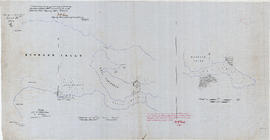
Map shows a survey conducted by the Canadian Pacific Railway of English Bay, Burrard Inlet and Coal Harbour, including a rough outline of area and lots. Note on map reads "Certified as a correct plan showing the land required for right of way Burrard Inlet B.C., February 22, 1886. H.J. Cambie, Engineer in Charge." Map is certified as correct and signed by various C.P.R. officials, including W.C. Van Horne.


![Mr. Chas Coburn [Copy of survey map of Zeballos]](/uploads/r/null/9/f/d/9fd592159853676e0317c030c447451cc252f4c835e7616d3215f851a12a5e48/95a518bd-678c-473f-abb2-e66b47c90e95-CVA99-7332_142.jpg)


![Miscellaneous [60 of 130]](/uploads/r/null/9/e/9ed32a03560d6a3a2c68861822f9fd15db32eb1d7bb2dddb194adba406842fce/583e7e72-0708-4d02-a88a-cd4a1a78ddc4-A64391_142.jpg)