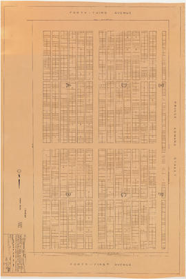
Portion of area bounded by 41st Avenue, Prince Edward Street & 43rd Avenue

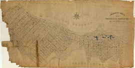
Plan to accompany report on proposed bridge at Marpole across North Arm of Fraser River
![Profile of pipe-line : Capilano intake to Little Mt. [Mountain] reservoir](/uploads/r/null/f/d/e/fde7fb6226629fad04bbf9be7365df117c8a21327882aba29740dae663d9c8fb/a5da6578-eab7-4510-9aa2-cc05f6ce537d-MAP866_142.jpg)
Profile of pipe-line : Capilano intake to Little Mt. [Mountain] reservoir

4th Ave & Granville St. convenience

Drainage and electrical wiring plan, for public convenience, Hamilton Street, Vancouver B.C.

Proposed convenience at Kingsway & Main St.

Map of Vancouver, British Columbia

The official street name map of the City of Vancouver
Contour plan of a portion of the City of Vancouver

Little Mountain reservoir. Proposed submerged fountain to be placed in centre of reservoir

Route of pipeline to Little Mountain reservoir

City of Vancouver and School District no. 39 : voting divisions

Sheet 20 : Granville Street to Ontario Street and Robson Street to Sixth Avenue

Sheet 15 : Ash Street to St. George Street and Fifty-eighth Avenue to Marine Drive

Sheet 16 : St. George Street to Argyle Street and Fifty-eighth Avenue to Fraser River

Sheet 2 : Slocan Street to Boundary Road and Charles Street to Triumph Street

Sheet 1 : Slocan Street to Boundary Road and Triumph Street to Burrard Inlet

Sheet 23 : Stanley Park to Granville Street and Robson Street to False Creek

Sheet A : University Endowment Lands to Imperial Street and waterfront to Fifth Avenue

Sheet F : Wallace Street to Trafalgar Street and Sixteenth Avenue to Twenty-seventh Avenue

Sheet H : Alexandra Street to Cambie Street and Fifteenth Avenue to Twenty-seventh Avenue

Sheet J : University Endowment Lands to Wallace Street and Twenty-ninth Avenue to Thirty-eighth Avenue
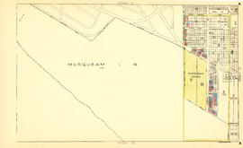
Sheet N : Musqueam Reserve to Wallace Street and Thirty-eighth Avenue to Forty-ninth Avenue
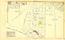
Sheet S : Musqueam Reserve to Macdonald Street and Forty-ninth Avenue to Fraser River

Sheet W : Fraser River to French Street and Fifty-ninth Avenue to Seventy-first Avenue

Sheet 4 : Prince Edward Street to Bruce Street and King Edward Avenue to Thirty-sixth Avenue

Sheet 10 : Earles Street to Boundary Road and Fortieth Avenue to Fiftieth Avenue
![[Houses in Kitsilano]](/uploads/r/null/5/5/a/55ae24b66c9ac313c74635184be9b941fe7fcc4e380ac339b43e37f6bab74b24/507164fd-a66d-41a4-924d-9f6f1160f8d1-CVA808-1_142.jpg)
[Houses in Kitsilano]
![[House and apartment building in Kitsilano]](/uploads/r/null/d/8/c/d8c500b307b5843514b956ebff2aea2d01dee6cf53aad693005afa24bad82cb9/49c0fa67-4e22-4316-9e46-f13f440aa067-CVA808-3_142.jpg)
[House and apartment building in Kitsilano]
![[Houses in Kitsilano]](/uploads/r/null/3/4/4/344d15796f2c3500294073c90fa782c0f0f8a63a01053fb3c2784628527b336b/53f61997-50b3-44f2-9970-73647972523e-CVA808-5_142.jpg)
[Houses in Kitsilano]
![[Houses in Kitsilano]](/uploads/r/null/a/3/f/a3f2366e0cb3221dc412ce3a991413c10590721500a7c5ead1b32b4de3ee3e8e/ffe1bef9-efb5-41aa-a862-59a8dd8597c8-CVA808-6_142.jpg)
[Houses in Kitsilano]
![[Property at] 721 East Pender Street](/uploads/r/null/3/3/330a6aca11b82b6d9bb21104efcff070208ad9f3671c48c01a65dcfcac681678/2dfe92f0-0a7d-4463-b6ce-e2174df77b50-A61544_142.jpg)
[Property at] 721 East Pender Street
![[Houses at] 830 Dunlevy Avenue [and] 844 Dunlevy Avenue](/uploads/r/null/7/b/7b302868b6dbecf997c1de15b0a160ee69a12bc117b39aacab3658e6c247426f/49e6b273-8ad8-4d73-bc44-03cb48cc08f7-A61547_142.jpg)
[Houses at] 830 Dunlevy Avenue [and] 844 Dunlevy Avenue
![[Houses at] 830 Dunlevy Avenue [and] 844 Dunlevy Avenue](/uploads/r/null/a/b/ab774dba04fd8cd8665d4da411c6651903d680b782910153b157e9cff139ed5c/c8d3dc4e-f599-424b-a28b-06e1afdc94fc-A61548_142.jpg)
[Houses at] 830 Dunlevy Avenue [and] 844 Dunlevy Avenue
![[House at] 407 Prior Street](/uploads/r/null/6/e/6e081069c8ff8bab03dec64ae3cfd4eec0fb84a7623d78236a41bb6ffeea2a79/958db080-fdca-400d-b8a8-cdc5916e05a5-A61550_142.jpg)
[House at] 407 Prior Street
![[House at] 413 Prior Street](/uploads/r/null/d/d/ddcfbd7295d7d62b1c16deaf597d6edd2f8b1721dc5f0aab00e7d8f6274e5c58/359e83e7-7449-4d6c-8cae-e656929051f7-A61551_142.jpg)
[House at] 413 Prior Street
![[Buildings at] 823 Union Street](/uploads/r/null/1/d/1dc286b482063b141ea45b30690276ac62a7fdb0f8d09622d7244d7d0ff15c0e/14c6766e-1cd2-4f41-9496-b4edc261567f-A61557_142.jpg)
[Buildings at] 823 Union Street
![[Buildings at] 511 East Georgia Street](/uploads/r/null/a/0/a027233c789dc4b0cef44312459f42bd32fc7ac0ca76451dd7677d5181531f55/5624957e-feac-4fae-8761-366f6477a3cf-A61560_142.jpg)
[Buildings at] 511 East Georgia Street

Project 2 area "h" and part of "b" : identification plan

Project 2, part of area "a" : aerial photograph

City of Vancouver : households and population by enumeration areas : 1961 census
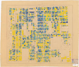
Age of buildings : Knight Street to Wales Street/Vivian Street and 37th Avenue to 53rd Avenue

Age of buildings : Nanaimo Street to Jellicoe Street and S.E. Marine Drive to Kent Avenue

Age of buildings : Main Street to Clark Drive/Knight Street and Broadway to King Edward Avenue

Age of buildings : Main Street to Knight Street and 57th Avenue to Kent Avenue
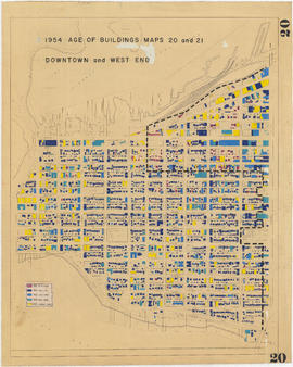
1954 : Age of buildings : Maps 20 and 21 : Downtown and West End
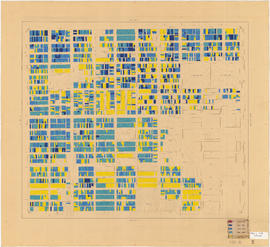
Age of buildings : Slocan Street to Boundary Road and Pender Street to 5th Avenue

Age of buildings : Arbutus Street to Oak Street and Broadway to King Edward Avenue

Age of buildings : Maple Street to Oak Street and 41st Avenue to 57th Avenue

Age of buildings : Granville Street to Fremlin Street and 72nd Avenue to 75th Avenue