
- AM1594-: MAP 385-: 1972-585.2
- Part
- 1890
Part of City of Vancouver Archives technical and cartographic drawing collection
Part is the inner sheet of an unfolded brochure, showing lots offered for sale in the northern portion of District Lot 540.
662 results with digital objects Show results with digital objects
Part of City of Vancouver Archives technical and cartographic drawing collection
Part is the inner sheet of an unfolded brochure, showing lots offered for sale in the northern portion of District Lot 540.

A souvenir and correct map of the location of all the fair buildings of the Vancouver Exhibition
Part of City of Vancouver Archives technical and cartographic drawing collection
Part contains text promoting the Western Canada Fair, Vancouver, and British Columbia.

A student to-day, a citizen tomorrow
Part of City of Vancouver Archives technical and cartographic drawing collection
Part contains textual information on Vancouver's growth and future planning initiatives.

Advertisements for Vancouver real estate
Part of City of Vancouver Archives technical and cartographic drawing collection

Part of City of Vancouver Archives technical and cartographic drawing collection
Item is an illustrated map of Vancouver and the North Shore. Locations on the map are given in the original native languages. A legend provides translations of the location names. The map is illustrated with images of animals, trees and a large image of a totem pole.
Jessiman, Mary

Part of City of Vancouver Archives technical and cartographic drawing collection
Part contains maps of the Richmond and downtown Vancouver transit systems, a street index to the Greater Vancouver map on the other side of the sheet, information on B.C. Electric transit routes, and general tourist information.

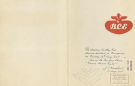
B.C. Electric plan showing bus stops in Vancouver
Part of City of Vancouver Archives technical and cartographic drawing collection
Item contains three maps showing transit routes, bus stops and bus zones in the city of Vancouver. Inset maps show the "Seasonal 'round the park route and stops" in Stanley Park and the "University bus route" in the University Endowment Lands. The main map extends from Smith Avenue to Burrard Inlet to Blanca Street to Marine Drive.

B.C. Electric Rly. Co. Ltd. plan showing transit services in Vancouver city as at end of 1951
Part of City of Vancouver Archives technical and cartographic drawing collection
Part is a map showing existing and proposed transit lines in Vancouver.
Part of City of Vancouver Archives technical and cartographic drawing collection
Part contains B.C. Electric logo and J.S. Matthews's annotations regarding the plan.
Bird's eye view of Vancouver, B.C.
Part of City of Vancouver Archives technical and cartographic drawing collection
Part contains an illustrated oblique view of Vancouver showing steamship lines, bridges, beaches, major roads, and the location and block numbers of East Vancouver Heights.

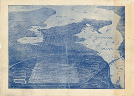
Part of City of Vancouver Archives technical and cartographic drawing collection
Part contains a map showing street car, interurban, and motor bus lines in from Vancouver to New Westminster, a map showing existing and projected power plants near Alouette and Stave Lakes, and a profile showing the existing and proposed plants.

Bus routes, city of Vancouver, November 26th 1937
Part of City of Vancouver Archives technical and cartographic drawing collection

Part of City of Vancouver Archives technical and cartographic drawing collection
Map shows a survey conducted by the Canadian Pacific Railway of English Bay, Burrard Inlet and Coal Harbour, including a rough outline of area and lots. Note on map reads "Certified as a correct plan showing the land required for right of way Burrard Inlet B.C., February 22, 1886. H.J. Cambie, Engineer in Charge." Map is certified as correct and signed by various C.P.R. officials, including W.C. Van Horne.

Champlain Heights : D.L. 334, group one, N.W.D.
Part of City of Vancouver Archives technical and cartographic drawing collection
Part is a map showing lot numbers, lot sizes, lot values and sidewalk crossings in the area from Rosemont Drive in the north to 63rd Avenue in the south and from Butler Street in the east to Kerr Street in the west.

Part of City of Vancouver Archives technical and cartographic drawing collection
Item is an annotated photocopy of a map of Chinatown showing streets, buildings and the number of stories in each building. Includes the area bounded by Taylor Street, Hastings Street, Gore Avenue and Keefer Street. The Provincial Historic Site Boundary, designated February 2, 1971, is drawn and indicated on the map. Notations pertaining to the boundary and the indication of the number of stories in each building appear on the map.

Part of City of Vancouver Archives technical and cartographic drawing collection
Item is a map of Chinatown showing streets, buildings and the number of stories in each building. Includes the area bounded by Taylor Street, Hastings Street, Gore Avenue and Keefer Street. The Provincial Historic Site Boundary, designated February 2, 1971, is drawn on the map.

Circulation map of Greater Vancouver : today's market data on Vancouver
Part of City of Vancouver Archives technical and cartographic drawing collection
Part contains maps and population and circulation data for three areas: Retail City Area, Retail Suburban Area, and All Other Country Area.

Part of City of Vancouver Archives technical and cartographic drawing collection
Map is a City Engineering Department base map of Vancouver, showing city blocks and Canadian Pacific, Canadian National and Great Northern Railway lines. Parks, golf courses, hospitals, schools, theatres and other structures are identified. "Metric Vancouver" and "Guide Map 15" appear in the bottom right corner of the map.

Part of City of Vancouver Archives technical and cartographic drawing collection
Map is a City Engineering Department base map of Vancouver, showing city blocks and Canadian Pacific, Canadian National and Great Northern Railway lines. Parks, golf courses, hospitals, schools, theatres and other structures are identified. "Guide Map 15" appears in the bottom right corner of the map.

Part of City of Vancouver Archives technical and cartographic drawing collection
Item is a street map of the City of Vancouver showing streets, schools, hospitals, parks and golf courses. A street index is included. A dial would have been attached at the centre of the map, but the dial has since been removed.

Part of City of Vancouver Archives technical and cartographic drawing collection
Item is a copy of sections of a November 1889 fire insurance map that have been pieced together. Includes the area between Seymour and Dunlevy Streets, from the south shore of the Burrard Inlet to Keefer Street. Map shows Chinatown, part of False Creek, and buildings and their uses (commercial, residential, industrial). The name of the business, business owner, or type of business is noted for most commercial and industrial buildings.

Part of City of Vancouver Archives technical and cartographic drawing collection
Item is a tracing of a map. The tracing shows city blocks, tramways, and railways in Vancouver. The map includes three illustrations, entitled: A glimpse of Cordova Street; In Stanley Park; View of city from Fairview.
Stuart, Allan K.

City of Vancouver : Canadian Pacific town site
Part of City of Vancouver Archives technical and cartographic drawing collection
Part contains four maps. The main map shows district lots and block numbers in Vancouver from Vine Street in the west to Boundary Avenue (Glen Drive) in the east and Stanley Park in the north to 9th Avenue (Broadway) in the south. Three smaller maps include an index plan to district lots in Vancouver, South Vancouver, New Westminster, and Burnaby; a world map showing Canadian Pacific mail steamship lines; and an index plan of Vancouver city limits. Part has been annotated with text describing a June 1888 land clearance plan and hand colouring indicating clearance status.

City of Vancouver : Canadian Pacific town site
Part of City of Vancouver Archives technical and cartographic drawing collection
Part contains four maps. The main map shows district lots and block numbers in Vancouver from Vine Street in the west to Boundary Avenue (Glen Drive) in the east and Stanley Park in the north to 9th Avenue (Broadway) in the south. Three smaller maps include an index plan to district lots in Vancouver, South Vancouver, New Westminster, and Burnaby; a world map showing Canadian Pacific mail steamship lines; and an index plan of Vancouver city limits.

Part of City of Vancouver Archives technical and cartographic drawing collection
Map shows Vancouver from West Boulevard to Boundary Road and from Burrard Inlet to the Fraser River. A portion of North Vancouver is also shown. Streets, parks, schools and golf courses are identified. Map joins with MAP 575 to create a complete map of the City of Vancouver.

City of Vancouver : residential lots, Area B, Champlain Heights : page 1
Part of City of Vancouver Archives technical and cartographic drawing collection
Part is the first of two sheets outlining details associated with the sale of lots in Champlain Heights as shown on the map "Champlain Heights : D.L. 334, group one, N.W.D." (LEG1315.1).

City of Vancouver : residential lots, Area B, Champlain Heights : page 2
Part of City of Vancouver Archives technical and cartographic drawing collection
Part is the second of two sheets outlining details associated with the sale of lots in Champlain Heights as shown on the map "Champlain Heights : D.L. 334, group one, N.W.D." (LEG1315.1).

Part of City of Vancouver Archives technical and cartographic drawing collection
Map shows Vancouver from the University Endowment Lands to South Granville Street and from English Bay to the Fraser River. Streets, parks, schools and golf courses are identified. Map joins with MAP 574 to create a map of the entire City of Vancouver.

City of Vancouver. Fifth Sale. Lots and blocks in Lot 540
Part of City of Vancouver Archives technical and cartographic drawing collection
Part is the outer sheet of an unfolded brochure advertising the sale of lots owned by the provincial government. The map included in the sheet is an index map of greater Vancouver, showing the location of District Lot 540.
![City of Vancouver [park sites June/80]](/uploads/r/null/9/4/9484add7c4684ea3838e4d00ee8add3ecf85d78d5aa8fe2780cae273e59556a5/bd2464d8-2aa9-4501-aba6-8b3f7d130a42-MAP1032_142.jpg)
City of Vancouver [park sites June/80]
Part of City of Vancouver Archives technical and cartographic drawing collection
Map is a City Engineering Department base map of Vancouver, with parks hand-coloured in green. Shows city blocks and Canadian Pacific, Canadian National and Great Northern Railway lines. Golf courses, hospitals, schools, theatres and other structures are identified. "Metric Vancouver" and "Guide Map 15" appear in the bottom right corner of the map.

City of Vancouver, British Columbia
Part of City of Vancouver Archives technical and cartographic drawing collection
Item is the western half of a map showing city blocks, transportation infrastructure, recreational facilities, hospitals, schools, theatres and other structures are identified. MAP 1036 is the eastern half of this map.
Vancouver (B.C.). Engineering Services

City of Vancouver, British Columbia
Part of City of Vancouver Archives technical and cartographic drawing collection
Item is a map which shows city streets and blocks. The map also notes the location of parks, golf courses and transportation infrastructure.

City of Vancouver, British Columbia
Part of City of Vancouver Archives technical and cartographic drawing collection
Item is the eastern half of a map showing city blocks, transportation infrastructure, recreational facilities, hospitals, schools, theatres and other structures are identified. MAP 1036b is the western half of this map.
Vancouver (B.C.). Engineering Services

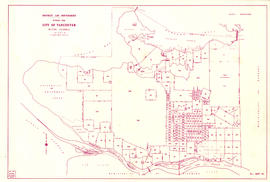
City of Vancouver, British Columbia : co-ordinate street index map 12
Part of City of Vancouver Archives technical and cartographic drawing collection
Map is City Engineering Department base map 149 of the City of Vancouver, showing city blocks, streets and railway lines, as well as the area code co-ordinates assigned by the department. Golf courses, hospitals, schools, theatres and other structures are also identified.

City of Vancouver, British Columbia : zoning diagram
Part of City of Vancouver Archives technical and cartographic drawing collection
Part contains a zoning map showing city streets, residential, apartment, commercial and industrial districts, as well as parkways and open spaces. Concentric circles spaced a mile apart on the map emanate from a point in downtown Vancouver.
![City of Vancouver, British Columbia [index map]](/uploads/r/null/d/4/d4fc7ef393680c6515927aa960de863e6fd9e846c3fac12499691549673dc4b7/eed36b0b-2e63-48f2-a7ee-02ed3de937b9-MAP682_142.jpg)
City of Vancouver, British Columbia [index map]
Part of City of Vancouver Archives technical and cartographic drawing collection
Item is an index map of Vancouver showing the boundaries of the sectional maps in this file. Map includes streets, roads and railways; blocks, lots and legal descriptions; First Nations reserves, government buildings, cemeteries, parks and businesses along the waterfront.
Vancouver (B.C.). Office of the City Engineer

City of Vancouver, Canadian Pacific Town Site
Part of City of Vancouver Archives technical and cartographic drawing collection
The map shows the area currently occupied by Downtown Vancouver and parts of Kitsilano. It shows the location of C.P.R. Wharf, Royal City Saw Mills, Hastings Saw Mill and Wharf, Leamy and Kyle's Saw Mill and other saw mills. "Streets graded and side-walked marked thus . . . . .." An insert shows "Canadian Pacific Mail Steamship Lines" on a map of the world. The north shore of Burrard Inlet indicates the locations of "Indian Houses" and a mission church.

Composite aerial mosaic of metropolitan Vancouver
Part of City of Vancouver Archives technical and cartographic drawing collection
Item is a map in the form of a composite aerial photograph showing Greater Vancouver, including West Vancouver, North Vancouver, Vancouver, Burnaby, New Westminster, Port Coquitlam, Coquitlam, Richmond, Delta and Surrey.

Part of City of Vancouver Archives technical and cartographic drawing collection
Part contains a street map of Vancouver showing streets, block numbers, bus routes, railway lines, boundaries, private roads and hospitals. The map includes a dial (a numbered circle, a paper indicator, a grid of block numbers and a street index used to find locations in Vancouver). A small inset shows the streets surrounding Queen Elizabeth Park, which are obscured on the main map where the indicator is attached.

Dial map of Greater Vancouver and suburbs
Part of City of Vancouver Archives technical and cartographic drawing collection
Part contains a street map of Vancouver, Burnaby, New Westminster, West Vancouver and North Vancouver showing block numbers, street car, bus, and railway lines, parks and hospitals. Map includes two dials (a numbered circle, a paper indicator, a grid of block numbers and a street index used to find locations). A small inset map shows the Capitol Hill/Scenic Park area of Burnaby in greater detail.

Dial map of Greater Vancouver and suburbs
Part of City of Vancouver Archives technical and cartographic drawing collection
Part contains a street map of Vancouver, Burnaby, New Westminster, West Vancouver, and North Vancouver showing railways, hospitals, parks and block numbers. The map includes two dials (numbered circles, paper indicators, a grid of block numbers and a street index used to find locations).
District lot boundaries with the City of Vancouver, British Columbia
Part of City of Vancouver Archives technical and cartographic drawing collection
Item is a map of the City of Vancouver showing district lot boundaries.
Vancouver (B.C.). Engineering Services

District lot boundaries with the City of Vancouver, British Columbia, D.L. map 40
Part of City of Vancouver Archives technical and cartographic drawing collection
Item is a map of the City of Vancouver showing district lot boundaries.

District lot index and street index (1st Avenue to Campbell Avenue)
Part of City of Vancouver Archives technical and cartographic drawing collection
Part contains two pages from the booklet accompanying a guide map of Greater Vancouver.
![D.L. 301 - Ward 8 [location of water pipes and hydrants]](/uploads/r/null/7/b/7b8914ef9132a2e20fa03008daf1a70f3de861b767043aaf338abaeeb42423d7/ce1965c6-6a58-454c-9630-0fcba30688bf-MAP72_142.jpg)
D.L. 301 - Ward 8 [location of water pipes and hydrants]
Part of City of Vancouver Archives technical and cartographic drawing collection
Item is a map showing the location of water pipes and hydrants for D.L. 301, in the area Main Street to Fraser Avenue (Fraser Street) and from 15th Avenue to 25th Avenue (King Edward). Pipes and hydrants are indicated in red ink.
South Vancouver (B.C.). Water Works Department

Part of City of Vancouver Archives technical and cartographic drawing collection
Part contains a map of East Vancouver Heights showing streets, block numbers and lot numbers, an index map showing the location of East Vancouver Heights in relation to the rest of the city, and text promoting the area.

Part of City of Vancouver Archives technical and cartographic drawing collection
Item consists of a planning map depicting the eastern portion of False Creek and surrounding areas.

Free map of Vancouver, New Westminster and surroundings
Part of City of Vancouver Archives technical and cartographic drawing collection
Part contains information about Vancouver parks, promotional text for British Columbia Electric Railway, and advertisements for other businesses.