![[View of Heatley Avenue from passenger seat of vehicle]](/uploads/r/null/5/b/5/5b5ff6fe16baf44f5f5659fa7140cc29704a227ee99b5bc91bafac724abdbe30/93f9ceda-c8cb-4833-84c6-0295cafb4d9d-CVA1095-01870_142.jpg)
[View of Heatley Avenue from passenger seat of vehicle]
- COV-S644-: CVA 1095-01870
- Item
- Feb.- Mar. 1974
Part of City of Vancouver fonds
Item is a photograph that depicts a view of Heatley Avenue between Union St. and E. Georgia St.
38 results with digital objects Show results with digital objects
[View of Heatley Avenue from passenger seat of vehicle]
Part of City of Vancouver fonds
Item is a photograph that depicts a view of Heatley Avenue between Union St. and E. Georgia St.
![[View of Strathcona street]](/uploads/r/null/f/9/e/f9ec534a97d74a93181f4b09a26371918dbf5b8c37424015b974c2f076fed1ac/6367adec-e0e5-43bf-8f0f-208521df206a-CVA1095-02522_142.jpg)
Part of City of Vancouver fonds
Item is a photograph that depicts a street view in Strathcona, likely the 600 block of Prior St.
![[Gore Avenue and Union Street intersection]](/uploads/r/null/4/5/9/459e89edeb596d8fe917ac13ca85b828658d954a835acd3b262c83912c357cd6/d4897c1d-4922-466f-8503-4eb0220e4600-CVA1095-14337_142.jpg)
[Gore Avenue and Union Street intersection]
Part of City of Vancouver fonds
![Strathcona/West End [Boulevard, 1 of 4]](/uploads/r/null/2/8/e/28e761fd7a52eda794e23e5ef5712329e35904db5bbccef0334ce95f534e5bce/0366d42c-b5ae-4644-a82b-4c282f55144a-CVA1095-15289_142.jpg)
Strathcona/West End [Boulevard, 1 of 4]
Part of City of Vancouver fonds
![Strathcona/West End [Boulevard, 2 of 4]](/uploads/r/null/7/e/f/7efa400facde2f74d5033914d7e44d1ffd9084de2b40afb1794ba7bbb09bcebd/91edbcdb-c1e5-45bc-b499-4212ccedfcd3-CVA1095-15290_142.jpg)
Strathcona/West End [Boulevard, 2 of 4]
Part of City of Vancouver fonds
![Strathcona/West End [Boulevard, 3 of 4]](/uploads/r/null/0/9/c/09c008703d8966fa8ddfbf7810b33bfb8c51204cfd52a36f090e897b66d50c10/75ab1905-6b97-49bc-a472-298e92b1432b-CVA1095-15291_142.jpg)
Strathcona/West End [Boulevard, 3 of 4]
Part of City of Vancouver fonds
![Strathcona/West End [Boulevard, 4 of 4]](/uploads/r/null/b/f/5/bf54984df53ed242fbdafbca66c94de99ac904a2d259fba804ea84ccaf7b2bfb/ada8399c-ed64-4f00-a542-fdeebca47e07-CVA1095-15292_142.jpg)
Strathcona/West End [Boulevard, 4 of 4]
Part of City of Vancouver fonds
![Strathcona/West End [Street construction]](/uploads/r/null/5/5/a/55a4a0391762a41256f5acd5cae813319ec8c95f01820a895bf9cab9f64bcff9/f9818c03-e5b0-4303-9640-341f84097293-CVA1095-15330_142.jpg)
Strathcona/West End [Street construction]
Part of City of Vancouver fonds
![[East Georgia Street and Princess Street intersection, 1 of 2]](/uploads/r/null/1/6/f/16fcdbf39e379be1e1ab6fe331a7a2f788f803421cbde594c0ff49944b1ebe07/590ea895-6016-49b8-a25c-7fe07058bde9-CVA1095-15339_142.jpg)
[East Georgia Street and Princess Street intersection, 1 of 2]
Part of City of Vancouver fonds
![[East Georgia Street and Princess Street intersection, 2 of 2]](/uploads/r/null/e/e/d/eedeeebb1b1343b1c4aa4b8d85c6f80ea20fe62889895ccd4d8bc76ad4aef35a/56c8b80b-1bae-4a48-85c5-87365ebc1a79-CVA1095-15340_142.jpg)
[East Georgia Street and Princess Street intersection, 2 of 2]
Part of City of Vancouver fonds

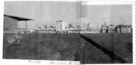
South west, south, and south east views from Hastings Viaduct
Part of City of Vancouver fonds
Item is a panoramic photograph showing south west, south, and south east views from the Hastings viaduct. On the left there is an arrow pointing to United Milling (feed and grain). Annotation on the back identifies the Manke Cabins on the right.
400 Block East Georgia across McLean Park
Part of City of Vancouver fonds
Item is a panoramic photograph showing the view across McLean Park to houses on the 400 block of East Georgia.

Part of City of Vancouver fonds
Item is a panoramic photograph showing the view across McLean Park to houses on the 400 block of East Georgia.
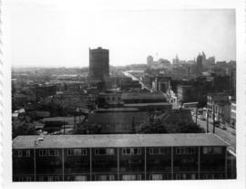
Old B.C. Electric Gas Plant from roof of McLean Park High-rise, looking east
Part of City of Vancouver fonds

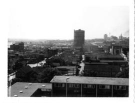
Intersection of Georgia and Dunlevy, looking north-west from roof of high-rise
Part of City of Vancouver fonds
View of Strathcona, McLean Park housing development in foreground
Part of City of Vancouver fonds

700 Block East Georgia, looking west
Part of City of Vancouver fonds
Looking north across new McLean Park at 700 block Keefer
Part of City of Vancouver fonds

New McLean park in foreground, 700 block Keefer in background
Part of City of Vancouver fonds
New McLean park in foreground, 700 block Keefer in background
Part of City of Vancouver fonds

Looking south and south-west from Hastings Viaduct
Part of City of Vancouver fonds
Item is a panoramic photograph showing the views looking south and south-west from Hastings Viaduct. Annotations on back identifying X's and arrows. The X on the left shows "956 keener, one of two remaining properties to be demolished." The X on the right shows "930 E Pender, one of two remaining buildings to be demolished." The arrows show: "Russian Church and Russian Hall to remain."

Part of City of Vancouver fonds
Item is a group of three photographs arranged vertically and affixed with tape. Annotation on top photo: "Rear of buildings in 400 block, Keefer Street." Annotation on middle photo: "East side of Burleith House." Annotation on bottom photo: "McLean Park High Rise in Background of Burleith House."

View of Keefer street and corner of high-rise housing in McLean Park, from Dunlevy and Keefer
Part of City of Vancouver fonds
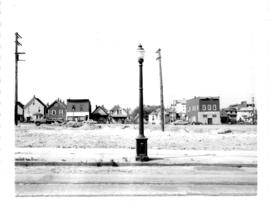
![The west end of Block 86 [Keefer Street - south side]](/uploads/r/null/7/1/8/718449a61ef28d000997ee1b4ee269fef37aabc4b15790ac496d415a6878035c/1751ccf4-5686-4608-93fb-1a3262368ccb-CVA181-22_142.jpg)
The west end of Block 86 [Keefer Street - south side]
Part of City of Vancouver fonds
Item is a photograph showing the west end of Block 86 (south side of Keefer Street). Stamp on back of photo: "Received by Property and Insurance Office, April 28, 1966".

Part of City of Vancouver fonds

Part of City of Vancouver fonds
Looking north towards Georgia Viaduct from Union Street
Part of City of Vancouver fonds
![Area A-2 [Looking north-west. from 1000 Block Union Street]](/uploads/r/null/1/8/c/18c52e9c6ad49618ad4970e1d4e3577ab59b064154b43a899ad4a2e76673fbc7/741daa67-a4fa-4c43-9c8d-f215ae9de615-CVA181-32_142.jpg)
Area A-2 [Looking north-west. from 1000 Block Union Street]
Part of City of Vancouver fonds
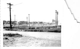
Looking south-west from Raymur Avenue
Part of City of Vancouver fonds

Looking south-west from Raymur Avenue
Part of City of Vancouver fonds

Area A-1, Relocation of Raymur Avenue
Part of City of Vancouver fonds

McLean Park with 700 Block Keefer in background
Part of City of Vancouver fonds

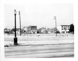
View of 600 block East Georgia Street

Part of City of Vancouver fonds
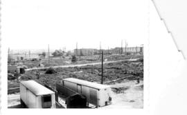
![Streets [19 of 139]](/uploads/r/null/e/9/e96230d9034940b1517a44b58d79d32491692a5e61950e8e82f4b6e62c1f5cba/ad724b71-1af8-4b87-ab3e-0ba48b4077d8-A64207_142.jpg)
Part of City of Vancouver fonds
Item is a photograph showing Prior Street between Hawks Avenue and Heatley Avenue.
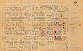
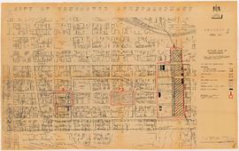
City of Vancouver redevelopment : project 1, area A-1 : City-owned land and buildings to be retained
Part of City of Vancouver fonds
Item is a map showing city-owned land, buildings in clearance areas to be retained, and boundaries of clearance areas. Base map shows streets, outlines of buildings, and topographic contour lines for the area from Main Street to Glen Drive and Alexander Street to Atlantic Street.

City of Vancouver redevelopment : project 1, area A-1 : detailed plan of redevelopment
Part of City of Vancouver fonds
Item is a map showing housing types, new streets and lanes, easements, and buildings to be retained as part of Project 1, and the boundaries of areas A1.1, A1.2, and A1.3. Base map shows streets, outlines of buildings, and topographic contour lines for the area from Main Street to Glen Drive and Alexander Street to Atlantic Street.