Showing 7 results

Archival description
City of Vancouver fonds Strathcona (Vancouver, B.C.) Public utilities
Print preview View:

7 results with digital objects Show results with digital objects

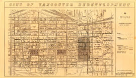
Project 2, part of area "a" : existing utilities, gas, electricity and telephone

Item is a map showing the gas lines, the overhead and underground electricity lines, the overhead and underground telephone lines, the fire alarms underground, the boundaries of project 2 clearance, the boundaries of project 1 clearance and the realignment of Raymur Avenue in the area from Railway Street in the north to Atlantic Street in the south and from Clark Drive in the east to Main Street in the west.

Attached label indicates that the map was approved by Council Sept. 17, 1963.

Project 2, part of area "a" : existing utilities, water and sewer

Item is a map showing the water pipes (10" and over), the sewers (15" and over), the direction of sewer flow, the boundaries of project 2 clearance, the boundaries of project 1 clearance and the realignment of Raymur Avenue in the area from Burrard Inlet in the north to Atlantic Street in the south and from Clark Drive in the east to Main Street in the west.

Attached label indicates that the map was approved by Council Sept. 17, 1963.

Redevelopment project no. 2 area a-6, including existing blocks 72, 73, 87, 88, D.L. 196 : site plan and general location of utilities plan no. 3

Item is a map created to depict utilities in the proposed project 2 area 6. The map shows fire alarms, sewer lines, water lines, gas lines, underground telephone lines, underground power lines, underground vaults, and curbs. Also noted are existing buildings which may be cleared in future projects, existing buildings in immediate vicinity of area a-6 which may remain, existing subdivisions to be cancelled, easement boundaries, approximate elevations at street intersections, approximate locations at contours and areas for disposal ("private development" and "public housing").