- AM1594-: MAP 851
- Item
- 19--
Part of City of Vancouver Archives technical and cartographic drawing collection
Map shows Juan de Fuca Strait, the San Juan Islands and the southern portion of Vancouver Island.
3 results with digital objects Show results with digital objects
Part of City of Vancouver Archives technical and cartographic drawing collection
Map shows Juan de Fuca Strait, the San Juan Islands and the southern portion of Vancouver Island.
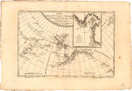
Carte de la cote N.O. de l' Amerique et de la cote N.E. de l'Asie
Part of City of Vancouver Archives technical and cartographic drawing collection
Item is a map showing the north west coast of America and the north east coast of Asia. Inset maps shows the entrance to Nootka Sound.

Carte de la riviere de Cook dans la partie N.O. de l'Amerique
Part of City of Vancouver Archives technical and cartographic drawing collection
Item is a nautical chart showing "Cook's River" [Cook Inlet, Alaska]; the inset chart shows Oonalaska Island and gives soundings for "Samganoodha harbour" and the waters around the island.

Part of City of Vancouver Archives technical and cartographic drawing collection
Map shows the Pacific Coast from Prince William Sound in the north though the Queen Charlotte Islands, Vancouver Island, Port S. Francisco and Sn. Diego to Sn. Domingo in the south.