
- VPD-S214-: CVA 480-200
- Item
- Dec. 1960
23 results with digital objects Show results with digital objects

Burrard Inlet : Vancouver sheet : British Columbia
Part of City of Vancouver Archives technical and cartographic drawing collection
Item is a map showing streets, roads, buildings, trails, railways, electric railways, bridges, swing bridges, foot bridges, churches, schools, post offices, wharves, piers, dikes, piling lighthouses, lightships, beacons, ranges, range lights, buoys, triangulation stations and geographical features in Burrard Inlet from Moodyville in the east to First Narrows in the west. A small index map shows this and other numbered sheets in relation to one another.
LaBelle family album, 1940-1948
File is a photograph album showing images of the Labelle family and friends, interior and exterior views of the their home at 2677 West 43rd in Vancouver, students at Little Flower Academy, vacationing, golfing at the Marine Drive Golf Club and the Beach Grove Gold Course, the 1939 royal tour of King George VI and Queen Elizabeth, workplace scenes at a B.C. Telephone Company office, trips to other parts of British Columbia, various military and air force personnel, as well as scrapbook materials from a trip to California including commercial and personal photographs, postcards and other ephemera. Names and places are further identified for most images in the album. Some images are duplicates to images found in the other LaBelle family albums of this accession.
LaBelle family

Part of City of Vancouver Archives technical and cartographic drawing collection
Item is a map showing major landmarks, railway lines, harbour lands reclaimed, proposed wharves and piers, retaining walls and dredging, and soundings in fathoms in Vancouver Harbour (Burrard Inlet) and False Creek.
The Port of Vancouver : Canada's key city of the West
Part of City of Vancouver Archives technical and cartographic drawing collection
Item is a brochure promoting Vancouver harbour as a hub of economic activity in the city. The brochure includes illustrations of harbour activity, facts about various aspects of the operations to show the harbour's capacity and facilities.

Tidal current chart, Vancouver Harbour : inside back cover
Part of City of Vancouver Archives technical and cartographic drawing collection
Part contains information about the survey data upon which the charts are based, and contact information for the Canadian Hydrographic Service.

Tidal current chart, Vancouver Harbour : maximum ebb at First Narrows
Part of City of Vancouver Archives technical and cartographic drawing collection

Tidal current chart, Vancouver Harbour : maximum flood at First Narrows
Part of City of Vancouver Archives technical and cartographic drawing collection

Tidal current chart, Vancouver Harbour : one hour after maximum ebb at First Narrows
Part of City of Vancouver Archives technical and cartographic drawing collection

Tidal current chart, Vancouver Harbour : one hour after maximum flood at First Narrows
Part of City of Vancouver Archives technical and cartographic drawing collection

Tidal current chart, Vancouver Harbour : one hour before maximum ebb at First Narrows
Part of City of Vancouver Archives technical and cartographic drawing collection

Tidal current chart, Vancouver Harbour : one hour before maximum flood at First Narrows
Part of City of Vancouver Archives technical and cartographic drawing collection

Tidal current chart, Vancouver Harbour : three hours after maximum ebb at First Narrows
Part of City of Vancouver Archives technical and cartographic drawing collection

Tidal current chart, Vancouver Harbour : three hours after maximum flood at First Narrows
Part of City of Vancouver Archives technical and cartographic drawing collection

Tidal current chart, Vancouver Harbour : two hours after maximum ebb at First Narrows
Part of City of Vancouver Archives technical and cartographic drawing collection

Tidal current chart, Vancouver Harbour : two hours after maximum flood at First Narrows
Part of City of Vancouver Archives technical and cartographic drawing collection

Tidal current chart, Vancouver Harbour : two hours before maximum ebb at First Narrows
Part of City of Vancouver Archives technical and cartographic drawing collection

Tidal current chart, Vancouver Harbour : two hours before maximum flood at First Narrows
Part of City of Vancouver Archives technical and cartographic drawing collection
Tidal current charts : Vancouver Harbour, British Columbia
Part of City of Vancouver Archives technical and cartographic drawing collection
Item is a booklet containing twelve charts showing tidal currents in Vancouver Harbour at different points in the tidal cycle.

Tidal current charts, Vancouver Harbour : inside front cover
Part of City of Vancouver Archives technical and cartographic drawing collection
Part contains explanatory text to be used in conjunction with the tidal current charts in the booklet.

Tidal current charts, Vancouver Harbour, British Columbia : front cover
Part of City of Vancouver Archives technical and cartographic drawing collection

Part of City of Vancouver Archives technical and cartographic drawing collection
Item contains both nautical chart and map data. Nautical chart data includes soundings, anchorages, ferry lines, wharves, and waterfront businesses. Map features include district lots, streets, railways, and municipal boundaries.
Vancouver Harbour : plan of south shore, Burrard Inlet between Heatley Ave. and Victoria Dr.
Part of City of Vancouver Archives technical and cartographic drawing collection
Item is a map which shows parcels of land along Burrard Inlet and district lots in downtown Vancouver. Piers, factories and mills along the waterfront are identified. Soundings are shown in feet.
National Harbours Board
Vancouver Harbour : plan of south shore, Burrard Inlet between Heatley Ave. and Victoria Dr.
Part of City of Vancouver Archives technical and cartographic drawing collection
Item is a map which shows parcels of land along Burrard Inlet and district lots in downtown Vancouver. Piers, factories and mills along the waterfront are identified. Soundings are shown in feet.
Vancouver Harbour : Sheet 2 (Point Grey to Second Narrows)
Part of City of Vancouver Archives technical and cartographic drawing collection
Item is a nautical chart of Burrard Inlet and Vancouver Harbour from Point Grey in the west to Second Narrows in the east, showing soundings in fathoms, tidal information, anchorages, beacons, and waterfront businesses.

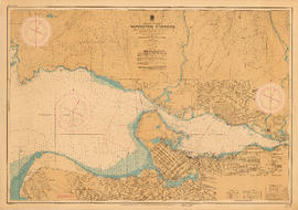
Vancouver Harbour. British Columbia
Part of City of Vancouver Archives technical and cartographic drawing collection
Item is a map sheet containing three nautical charts. The main map shows English Bay and Burrard Inlet and the land bordering these bodies of water, including North and West Vancouver, Downtown Vancouver, the University Endowment Lands and Port Moody. Inset maps depict the north arm of Burrard Inlet and a chart showing Vancouver Island in relation to the B.C. coast and the state of Washington, U.S.A.
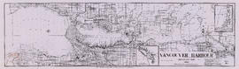
Vancouver Harbour, British Columbia
Part of City of Vancouver Archives technical and cartographic drawing collection
Item is a nautical chart of Burrard Inlet, including the southern portions of the North Arm of Burrard Inlet. The map shows depth soundings, harbour anchorages, headlines, beacons, buoys, bells, piers and wharves. The map also shows lot numbers, municipal boundaries and major street names of the southern portion of North Vancouver and the northern portions of Point Grey, Kitsilano, Mt. Pleasant, Fairview, Hastings Townsite, Burnaby and Port Moody from the Coquitlam municipal boundary in the east to the western boundary of the Vancouver harbour (between Point Atkinson and Point Grey) in the west. The item also includes a key map showing the location of the Vancouver Harbour in relation to northwestern Washington and Vancouver Island and an inset map showing lots surrounding the north arm of Burrard Inlet to the Inlailawatash Indian Reserve.
Vancouver Harbour, British Columbia, 1964
Part of City of Vancouver Archives technical and cartographic drawing collection
Item is a nautical chart showing English Bay and Burrard Inlet with soundings in feet, anchorages, locations of submarine cables, and ferry lines. Land features include city blocks and district lot numbers. Includes inset maps of the North Arm of Burrard Inlet and Vancouver Island.
![Vancouver Police Patrol No. 1 [Police launch at dock]](/uploads/r/null/5/8/4/584e53989fbbacbc127136fa5099a82b57c4b803eea2d3e550f1b2197d83cef2/0b36a4a2-69fc-40e9-a972-dbe1d7babb51-CVA480-201_142.jpg)
Vancouver Police Patrol No. 1 [Police launch at dock]
Item is a photograph of a police patrol boat docked in front of the New England Fish Co. building ; two uniformed police officers are on the patrol boat and dock workers are in the background.