
Tidal current charts, Vancouver Harbour, British Columbia : front cover
- AM1594-: MAP 1179-: LEG1348.11
- Part
- Feb. 1952
Part of City of Vancouver Archives technical and cartographic drawing collection
Tidal current charts, Vancouver Harbour, British Columbia : front cover
Part of City of Vancouver Archives technical and cartographic drawing collection

Tidal current charts, Vancouver Harbour : inside front cover
Part of City of Vancouver Archives technical and cartographic drawing collection
Part contains explanatory text to be used in conjunction with the tidal current charts in the booklet.

Tidal current chart, Vancouver Harbour : inside back cover
Part of City of Vancouver Archives technical and cartographic drawing collection
Part contains information about the survey data upon which the charts are based, and contact information for the Canadian Hydrographic Service.

Tidal current chart, Vancouver Harbour : one hour before maximum ebb at First Narrows
Part of City of Vancouver Archives technical and cartographic drawing collection

Tidal current chart, Vancouver Harbour : two hours before maximum ebb at First Narrows
Part of City of Vancouver Archives technical and cartographic drawing collection

Tidal current chart, Vancouver Harbour : maximum ebb at First Narrows
Part of City of Vancouver Archives technical and cartographic drawing collection

Tidal current chart, Vancouver Harbour : three hours after maximum ebb at First Narrows
Part of City of Vancouver Archives technical and cartographic drawing collection

Tidal current chart, Vancouver Harbour : one hour after maximum ebb at First Narrows
Part of City of Vancouver Archives technical and cartographic drawing collection

Tidal current chart, Vancouver Harbour : two hours after maximum ebb at First Narrows
Part of City of Vancouver Archives technical and cartographic drawing collection

Tidal current chart, Vancouver Harbour : one hour before maximum flood at First Narrows
Part of City of Vancouver Archives technical and cartographic drawing collection

Tidal current chart, Vancouver Harbour : two hours before maximum flood at First Narrows
Part of City of Vancouver Archives technical and cartographic drawing collection

Tidal current chart, Vancouver Harbour : maximum flood at First Narrows
Part of City of Vancouver Archives technical and cartographic drawing collection

Tidal current chart, Vancouver Harbour : one hour after maximum flood at First Narrows
Part of City of Vancouver Archives technical and cartographic drawing collection

Tidal current chart, Vancouver Harbour : two hours after maximum flood at First Narrows
Part of City of Vancouver Archives technical and cartographic drawing collection

Tidal current chart, Vancouver Harbour : three hours after maximum flood at First Narrows
Part of City of Vancouver Archives technical and cartographic drawing collection

Part of City of Vancouver Archives technical and cartographic drawing collection
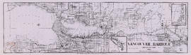
Item is a map showing major landmarks, railway lines, harbour lands reclaimed, proposed wharves and piers, retaining walls and dredging, and soundings in fathoms in Vancouver Harbour (Burrard Inlet) and False Creek.

Vancouver Harbour. British Columbia
Part of City of Vancouver Archives technical and cartographic drawing collection
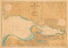
Item is a map sheet containing three nautical charts. The main map shows English Bay and Burrard Inlet and the land bordering these bodies of water, including North and West Vancouver, Downtown Vancouver, the University Endowment Lands and Port Moody. Inset maps depict the north arm of Burrard Inlet and a chart showing Vancouver Island in relation to the B.C. coast and the state of Washington, U.S.A.
Vancouver Harbour, British Columbia, 1964
Part of City of Vancouver Archives technical and cartographic drawing collection
Item is a nautical chart showing English Bay and Burrard Inlet with soundings in feet, anchorages, locations of submarine cables, and ferry lines. Land features include city blocks and district lot numbers. Includes inset maps of the North Arm of Burrard Inlet and Vancouver Island.
Vancouver Harbour : Sheet 2 (Point Grey to Second Narrows)
Part of City of Vancouver Archives technical and cartographic drawing collection
Item is a nautical chart of Burrard Inlet and Vancouver Harbour from Point Grey in the west to Second Narrows in the east, showing soundings in fathoms, tidal information, anchorages, beacons, and waterfront businesses.

Burrard Inlet : Vancouver sheet : British Columbia
Part of City of Vancouver Archives technical and cartographic drawing collection
Item is a map showing streets, roads, buildings, trails, railways, electric railways, bridges, swing bridges, foot bridges, churches, schools, post offices, wharves, piers, dikes, piling lighthouses, lightships, beacons, ranges, range lights, buoys, triangulation stations and geographical features in Burrard Inlet from Moodyville in the east to First Narrows in the west. A small index map shows this and other numbered sheets in relation to one another.

Part of City of Vancouver Archives technical and cartographic drawing collection
Item contains both nautical chart and map data. Nautical chart data includes soundings, anchorages, ferry lines, wharves, and waterfront businesses. Map features include district lots, streets, railways, and municipal boundaries.