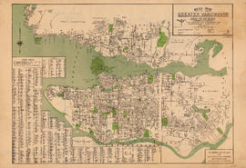
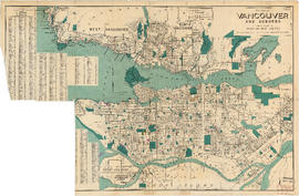
Dial map of Greater Vancouver and suburbs
- AM738-S1-: MAP 881-: LEG1256.5
- Part
- 1953
Part contains a street map of Vancouver, West Vancouver, North Vancouver, and Burnaby showing railways, hospitals, parks and block numbers. The map includes the printed portion of the dial (a numbered circle, a grid of block numbers and a street index used to find locations), but no indicator is attached. A small inset shows the streets of Gleneagles in West Vancouver.