
Plan of Greater Vancouver. British Columbia
- COV-S371---: LEG1153.086
- Item
- 1911
Part of City of Vancouver fonds
Item is a commercially printed map which has been annotated to depict various Burrard Inlet crossings and underwater features.
Plan of Greater Vancouver. British Columbia
Part of City of Vancouver fonds
Item is a commercially printed map which has been annotated to depict various Burrard Inlet crossings and underwater features.

Plan showing relative position of different water districts
Part of City of Vancouver fonds
Item is a map which depicts the boundaries between the various water districts between the Capilano River and the North Arm of Burrard Inlet.
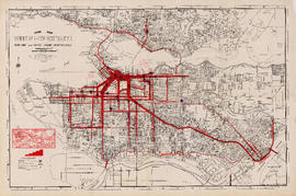
Guide map : Vancouver, New Westminster, Burnaby and North Shore municipalities
Item is a City Map and White Print Co. street map of Vancouver, Burnaby, New Westminster, North Vancouver and West Vancouver, annotated to show traffic density along major arteries. Various locations along the arteries are marked, but the significance of the markings is unclear. A small key map showing Vancouver in relation to the rest of the lower mainland has also been added to the base map.
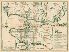
Map of Greater Vancouver showing principal streets
Part of Simson family fonds
Part contains a map of Greater Vancouver showing streets, parks, golf courses, mountains, rivers, and distances from city centre, and a guide to streetcar routes to selected attractions.
![McRoberts Island [Sea Island]](/uploads/r/null/6/9/6981a571c6d3102ee36ac270cce0eca9727531a3a9b4dd09f46f6f61adbbadbe/b8c696f2-5181-4f84-9e76-6420f9b2e916-Map800_142.jpg)
Part of City of Vancouver Archives technical and cartographic drawing collection
Item is a map of McRoberts Island (now named Sea Island). The map shows the locations of farms and the Vancouver Airport, notes on flora and geographical features, crops & dates/partitions of settlement.
Matthews, James Skitt, Major

Part of City of Vancouver Archives technical and cartographic drawing collection
Item is a map of Greater Vancouver annotated to show ward boundaries. Base map shows streets, some district lot numbers, and distances from City Hall. A smaller detail map shows Granville Island.

Part of City of Vancouver Archives technical and cartographic drawing collection
Item is a map showing topography, roads, trails, railways, bridges, boundaries, reserves, power lines, telephone lines, triangulation stations, camera stations, bench marks, houses, barns, mills, factories, schools, churches, post offices, telephone exchanges, mines and geographic features in the Pitt Meadows area and extending south through Cloverdale and Langley to the United States border. A small index map shows the area covered by the primary map in relation to other maps in the series.

Part of City of Vancouver Archives technical and cartographic drawing collection
Item is a map showing topography, roads, trails, railways, bridges, boundaries, reserves, power lines, telephone lines, triangulation stations, camera stations, bench marks, houses, barns, mills, factories, schools, churches, post offices, telephone exchanges, mines and geographic features in the Pitt Lake area, including Coquitlam Mountain, Mount Blanshard, and Siwash Island. A small index map shows the area covered by the primary map in relation to other maps in the series.

Indexed guide map of the city of Vancouver and suburbs
Part of City of Vancouver Archives technical and cartographic drawing collection
Part is a map showing district lots, blocks, and boundaries between the City of Vancouver, Point Grey, South Vancouver, Burnaby, New Westminster, and parts of Richmond, North Vancouver and West Vancouver. Concentric circles indicate the distance in miles from the intersection of Main Street and Hastings Street in intervals of 1/2 mile.

Commercial map of Greater Vancouver and district
Part of City of Vancouver Archives technical and cartographic drawing collection
Item is a map sheet containing two maps. The principal map depicts greater Vancouver, including portions of North and West Vancouver, Richmond and Surrey. The information depicted on the map includes streets, postal blocks, streetcar and railway lines, parks and golf courses, and schools. The map includes 1/2 mile distance circles centred on old City Hall at Main and Hastings.
The sheet includes an inset map of Granville Island. Depth of water given along shorelines of Burrard Inlet, English Bay, and along the West Vancouver coast from First Narrows to Howe Sound. The sheet includes an index of streets.
Part of City of Vancouver Archives technical and cartographic drawing collection
Part contains a map of the Greater Vancouver area showing topographic contour lines at 500-foot intervals, roads and road characteristics, railways, parks, towns, reserves, elevations, airports, streams, lakes, and adminstrative boundaries. Includes a key plan of adjoining sheets published in the same series and a small ancillary map showing the declination of the compass needle in 1958.

Greater Vancouver sewerage and drainage district : general and statistical information
Part of City of Vancouver Archives technical and cartographic drawing collection

Greater Vancouver and Fraser Valley
Part of City of Vancouver Archives technical and cartographic drawing collection
Part contains a map showing the B.C. Electric railway line within the Greater Vancouver and Fraser Valley area, other railway lines, main roads, municipal boundaries, industrial sites, airports and ports. An inset map shows the total area served by B.C. Electric within British Columbia and the location of Greater Vancouver and the Fraser Valley within that area.

Transit system map of Greater Vancouver, B.C.
Part of City of Vancouver Archives technical and cartographic drawing collection
Part contains a map of Greater Vancouver showing bus lines, route numbers, B.C. Electric installations, block numbers, points of interest and amenities; an inset map showing streets in Gleneagles, Whytecliff, and Horseshoe Bay; and an inset map showing streets in Port Moody, Coquitlam, and Maillardville.

Item is a map of Greater Vancouver showing streets, parks, schools and hospitals; includes street index.
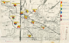
General overview of high-tech industry demographics
Part of City of Vancouver fonds
Item is a map annotated to show technology industry activities in Lower Mainland municipalities. Categories of activity are design/fabrication, system design/consulting, research/development, education, fabrication/manufacturing, and other. Item includes a list of the number of firms in each location.

Composite aerial mosaic of metropolitan Vancouver
Part of City of Vancouver Archives technical and cartographic drawing collection
Item is a map in the form of a composite aerial photograph showing Greater Vancouver, including West Vancouver, North Vancouver, Vancouver, Burnaby, New Westminster, Port Coquitlam, Coquitlam, Richmond, Delta and Surrey.

Part of City of Vancouver Archives technical and cartographic drawing collection
Item is a map showing topography, roads, trails, railways, bridges, boundaries, reserves, power lines, telephone lines, triangulation stations, camera stations, bench marks, houses, barns, mills, factories, schools, churches, post offices, telephone exchanges, mines and geographic features in the area of South Burnaby and New Westminster, extending south through Surrey and White Rock to the United States border. A small index map shows the area covered by the primary map in relation to other maps in the series.

Part of City of Vancouver Archives technical and cartographic drawing collection
Item is an illustrated tourist map showing parks, major landmarks and major streets in Vancouver and parts of Richmond, Burnaby, West Vancouver and North Vancouver.

Direct mail as an advertising and marketing medium
Part of City of Vancouver Archives technical and cartographic drawing collection
Part is the inside cover for a street map of Greater Vancouver and contains text advertising Roy Wrigley's direct mail campaigns

Map of Vancouver, Burnaby, New Westminster, British Columbia : street index and advertisements
Part of City of Vancouver Archives technical and cartographic drawing collection
Part contains a street index for the main map of Vancouver on the other side of the sheet, advertisements for Bekins Moving and Storage and Allied Van Lines, and three maps showing the companies' service areas in the United States, Canada, and British Columbia and Alberta. An annotation reads: "Oppenheimer collection."

Vancouver, New Westminster, Delta and Surrey : postal area
Part of City of Vancouver Archives technical and cartographic drawing collection
Item is a map which shows the boundaries of postal areas and their corresponding numbers and names.

Guide map: Vancouver - New Westminster, Burnaby and North Shore municipalities
Part of City of Vancouver Archives technical and cartographic drawing collection
Item is a street map of Vancouver, Burnaby, New Westminster and the North Shore showing city limits and boundaries of central office areas. Map has been annotated to show the old and new Vancouver telephone exchange boundaries prior to and after the introduction of flat rate service on November 1, 1937.

Part of City of Vancouver Archives technical and cartographic drawing collection
Part contains a street map of Greater Vancouver with street index, an inset map showing the streets of Horseshoe Bay, Whytecliff, and Caulfeild, and advertising Chevron gasolines and RPM motor oils.

Principal freight railway facilities of British Columbia Hydro and Power Authority
Part of City of Vancouver Archives technical and cartographic drawing collection
Part contains a map showing the B.C. Electric railway (including the Vancouver and Lulu Island branch), other railways, interchange points and municipal city boundaries.

Part of City of Vancouver Archives technical and cartographic drawing collection
Item is a map showing the locations and names of major businesses and corporations in the Greater Vancouver area. The map also shows major roads, highways, railways and proposed highway routes. 5 mile and 10 mile radius circles are depicted around the "geographical centre of metropolitan Vancouver." Map background is a mosaic of aerial photographs.

British Columbia Electric Railway Company Limited : Vancouver Island system and Mainland system
Part of City of Vancouver Archives technical and cartographic drawing collection
Part contains two maps showing city, suburban, and interurban railway lines, transmission lines, generating stations, substations, and transformers.

Part of City of Vancouver Archives technical and cartographic drawing collection
Part contains maps of the Richmond and downtown Vancouver transit systems, a street index to the Greater Vancouver map on the other side of the sheet, information on B.C. Electric transit routes, and general tourist information.

Part of City of Vancouver Archives technical and cartographic drawing collection
Item consists of an illustrated map of the Vancouver area and an overlay showing dates of settlement in various areas and the opening dates of regional landmarks. A poem about the growth of Vancouver has been included on the right-hand side of the map. Verso contains a seemingly unrelated drawing dated 1911 and showing front and side elevations for a church building.

Map of Greater Vancouver and environs showing principal auto roads and highways
Part of City of Vancouver Archives technical and cartographic drawing collection

Map and guide of Greater Vancouver
Part of City of Vancouver Archives technical and cartographic drawing collection
Item is a map and guide designed to be folded into a pocket-sized cover. Map shows streets, legal addresses, railway lines, and distances from City Hall. Text includes information on streetcar lines, train and steamship services, postal service, places of worship, office buildings, schools, and theatres.

Map of Greater Vancouver Water District
Part of City of Vancouver Archives technical and cartographic drawing collection

Map of New Westminster District, B.C
Part of City of Vancouver Archives technical and cartographic drawing collection
Item is a map showing District Lots in Vancouver, and township/range designations in other areas. The map also shows False Creek Trail, North Arm Road, False Creek Road, Granville Road from Granville to Hastings, New Westminster and Burrard Inlet Road, North Road, Semiahmoo Road, New Westminster and Yale Wagon Road, and others. Annotated by W. E. Graveley, 1885, to show additional features including Kingsway, Haney, Albion Camp, etc.

Map of Greater Vancouver and environs showing principal auto roads and highways
Part of City of Vancouver Archives technical and cartographic drawing collection

Wrigley's new map of Vancouver and Lower Mainland
Part of City of Vancouver Archives technical and cartographic drawing collection
Part contains a map showing streets and block numbers in Vancouver, West Vancouver, North Vancouver, Burnaby, New Westminster and the northern part of Richmond.

Street index of Vancouver and lower mainland
Part of City of Vancouver Archives technical and cartographic drawing collection
Part contains the street index for a map of Greater Vancouver and advertisements for Roy Wrigley Printing and Publishing Co. and A.E. Austin and Co. Limited.

Guide map : Vancouver, New Westminster, Burnaby and North Shore municipalities : street index
Part of City of Vancouver Archives technical and cartographic drawing collection

Part of City of Vancouver Archives technical and cartographic drawing collection
Part contains a map of Greater Vancouver showing the locations of Bekins Moving and Storage, distances from the Burrard Street and York Street location and city streets. Part includes four photographic images of points of interest in Vancouver.

Railroad map of Greater Vancouver, British Columbia
Part of City of Vancouver Archives technical and cartographic drawing collection
Item is a map which shows the routes of the Great Northern Railway, the Burlington Northern Railway, the Canadian Northern Pacific Railway, the British Columbia Electric Railway, the Canadian Pacific Railway, the Canadian National Railway, and the Pacific Great Eastern Railway. The map notes years of railway completion, years of abandonment, existing trackage, abandoned trackage, proposed trackage, tunnel trackage, and important dates.

Map of Greater Vancouver and environs showing principal auto roads and highways
Part of City of Vancouver Archives technical and cartographic drawing collection
Part contains a map of Greater Vancouver showing major roads, parks, lakes, mountains, beaches, and distances from the post office.

Part of City of Vancouver Archives technical and cartographic drawing collection
Item is a topographical map showing lands alienated or covered by application under the Land Act, timber leases, native reserves, government reserves, and various boundaries, as well as campsites, picnic sites, forest service lookouts, post offices, settlements, schools, hospitals, mines, dykes, historic monuments, roads, trails, railways, power lines, phone lines, air harbour or seaplane anchorages, etc. Sheet contains an index map showing adjoining maps in the series.

Street map of Greater Vancouver, B.C.
Part of City of Vancouver Archives technical and cartographic drawing collection
Part contains a street map of Greater Vancouver showing block numbers, parks, golf courses, cemeteries, and hospitals; inset maps showing streets in Coquitlam and the Horseshoe Bay area; and a map showing Highway 99 from Horseshoe Bay to Squamish.

Part of City of Vancouver Archives technical and cartographic drawing collection
Part contains a street map of Greater Vancouver.

Street map of Greater Vancouver, B.C.
Part of City of Vancouver Archives technical and cartographic drawing collection
Part contains a street map of Greater Vancouver showing block numbers, neighbourhood boundaries, schools, churches by denomination, and main shopping centres. An inset map shows the Forest Hills - Canyon Heights area.

Plan of Greater Vancouver, British Columbia
Part of City of Vancouver Archives technical and cartographic drawing collection
Item is a map of Greater Vancouver from Alma Road (Alma Street) to Boundary Road and Burrard Inlet to King Edward Avenue. Map shows district lot, block, and lot numbers, waterfront businesses, rail lines, schools, parks, beaches, and concentric circles indicating distances from a point located approximately at the intersection of Cambie and Hastings Streets.

Part of City of Vancouver Archives technical and cartographic drawing collection
Part is an overlay designed to be used with a pictorial map of Greater Vancouver to show key dates in various areas.
Part of City of Vancouver Archives technical and cartographic drawing collection
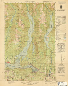
Item is a map showing topography, roads, trails, railways, bridges, boundaries, reserves, power lines, telephone lines, triangulation stations, camera stations, bench marks, houses, barns, mills, factories, schools, churches, post offices, telephone exchanges, mines and geographic features in the area of Indian Arm and Coquitlam Lake, extending south to Port Moody, Port Coquitlam, and the northeast part of Burnaby. A small index map shows the area covered by the primary map in relation to other maps in the series.
![Commercial map of Greater Vancouver and district [assessment districts]](/uploads/r/null/0/9/2/0928add1a06ab55bc236f8bebb87712b7e6ad4422db32cc3065efe7c9da96c04/b5b4129d-f9ba-49b9-a863-2ab6e954897e-MAP102_142.jpg)
Commercial map of Greater Vancouver and district [assessment districts]
Part of City of Vancouver Archives technical and cartographic drawing collection
Item is a printed map of greater Vancouver which has been used as a base map. The base map is the 1924 version of the Commercial Map of Greater Vancouver and District. On this copy has been drawn the boundaries of districts, numbered 1-12; inside the drawn boundaries are each district's area in acrea, population and assessed value of property. While the base map is of the pre-amalgamation municipalities, the assessment districts (?) cover the entire post-amalgamation extent of Vancouver.
Dial map of Vancouver and suburbs
Part consists of a street map of Vancouver, West Vancouver, North Vancouver, and Burnaby. Part includes the printed portion of the dial (a numbered circle, a grid of block numbers and a street index used to find locations), but no indicator is attached.

Dial map of Greater Vancouver and suburbs
Part contains a street map of Vancouver, West Vancouver, North Vancouver, and Burnaby showing railways, hospitals, parks and block numbers. The map includes the printed portion of the dial (a numbered circle, a grid of block numbers and a street index used to find locations), but no indicator is attached. A small inset shows the streets of Gleneagles in West Vancouver.