
Guide map : Vancouver, New Westminster, Burnaby and North Shore municipalities : street index
- AM1594-: MAP 217-: LEG1325.10
- Part
- 1935
Part of City of Vancouver Archives technical and cartographic drawing collection
30 results with digital objects Show results with digital objects
Guide map : Vancouver, New Westminster, Burnaby and North Shore municipalities : street index
Part of City of Vancouver Archives technical and cartographic drawing collection

Guide map : Vancouver, New Westminster, Burnaby and North Shore municipalities
Part of City of Vancouver Archives technical and cartographic drawing collection
Part contains a map of Greater Vancouver showing city streets, schools, firehalls, parks and golf courses, railways, street railways and interurban lines, hospitals and bus routes.

Part of City of Vancouver Archives technical and cartographic drawing collection
Part contains a map of Greater Vancouver showing the locations of Bekins Moving and Storage, distances from the Burrard Street and York Street location and city streets. Part includes four photographic images of points of interest in Vancouver.

Map of Vancouver, Burnaby, New Westminster, British Columbia : street index and advertisements
Part of City of Vancouver Archives technical and cartographic drawing collection
Part contains a street index for the main map of Vancouver on the other side of the sheet, advertisements for Bekins Moving and Storage and Allied Van Lines, and three maps showing the companies' service areas in the United States, Canada, and British Columbia and Alberta. An annotation reads: "Oppenheimer collection."

Map of Greater Vancouver and environs showing principal auto roads and highways
Part of City of Vancouver Archives technical and cartographic drawing collection
Part contains a map of Greater Vancouver showing major roads, parks, lakes, mountains, beaches, and distances from the post office.

Indexed guide map of the city of Vancouver and suburbs
Part of City of Vancouver Archives technical and cartographic drawing collection
Part is a map showing district lots, blocks, and boundaries between the City of Vancouver, Point Grey, South Vancouver, Burnaby, New Westminster, and parts of Richmond, North Vancouver and West Vancouver. Concentric circles indicate the distance in miles from the intersection of Main Street and Hastings Street in intervals of 1/2 mile.
Part of City of Vancouver Archives technical and cartographic drawing collection
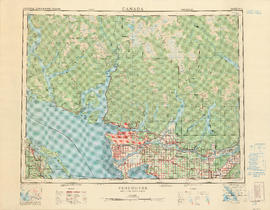
Part contains a map of the Greater Vancouver area showing topographic contour lines at 500-foot intervals, roads and road characteristics, railways, parks, towns, reserves, elevations, airports, streams, lakes, and adminstrative boundaries. Includes a key plan of adjoining sheets published in the same series and a small ancillary map showing the declination of the compass needle in 1958.

Part of City of Vancouver Archives technical and cartographic drawing collection
Part contains a street map of Greater Vancouver with street index, an inset map showing the streets of Horseshoe Bay, Whytecliff, and Caulfeild, and advertising Chevron gasolines and RPM motor oils.

Map of Greater Vancouver and environs showing principal auto roads and highways
Part of City of Vancouver Archives technical and cartographic drawing collection

Map of Greater Vancouver and environs showing principal auto roads and highways
Part of City of Vancouver Archives technical and cartographic drawing collection

Wrigley's new map of Vancouver and Lower Mainland
Part of City of Vancouver Archives technical and cartographic drawing collection
Part contains a map showing streets and block numbers in Vancouver, West Vancouver, North Vancouver, Burnaby, New Westminster and the northern part of Richmond.

Street index of Vancouver and lower mainland
Part of City of Vancouver Archives technical and cartographic drawing collection
Part contains the street index for a map of Greater Vancouver and advertisements for Roy Wrigley Printing and Publishing Co. and A.E. Austin and Co. Limited.

Direct mail as an advertising and marketing medium
Part of City of Vancouver Archives technical and cartographic drawing collection
Part is the inside cover for a street map of Greater Vancouver and contains text advertising Roy Wrigley's direct mail campaigns

Greater Vancouver and Fraser Valley
Part of City of Vancouver Archives technical and cartographic drawing collection
Part contains a map showing the B.C. Electric railway line within the Greater Vancouver and Fraser Valley area, other railway lines, main roads, municipal boundaries, industrial sites, airports and ports. An inset map shows the total area served by B.C. Electric within British Columbia and the location of Greater Vancouver and the Fraser Valley within that area.

Principal freight railway facilities of British Columbia Hydro and Power Authority
Part of City of Vancouver Archives technical and cartographic drawing collection
Part contains a map showing the B.C. Electric railway (including the Vancouver and Lulu Island branch), other railways, interchange points and municipal city boundaries.

Part of City of Vancouver Archives technical and cartographic drawing collection
Part contains a map showing trunk sewers and drains constructed, facilities under design and/or construction, pumping stations and sewage treatment plants in the Greater Vancouver area.

Greater Vancouver sewerage and drainage district : general and statistical information
Part of City of Vancouver Archives technical and cartographic drawing collection

British Columbia Electric Railway Company Limited : Vancouver Island system and Mainland system
Part of City of Vancouver Archives technical and cartographic drawing collection
Part contains two maps showing city, suburban, and interurban railway lines, transmission lines, generating stations, substations, and transformers.

Transit system map of Greater Vancouver, B.C.
Part of City of Vancouver Archives technical and cartographic drawing collection
Part contains a map of Greater Vancouver showing bus lines, route numbers, B.C. Electric installations, block numbers, points of interest and amenities; an inset map showing streets in Gleneagles, Whytecliff, and Horseshoe Bay; and an inset map showing streets in Port Moody, Coquitlam, and Maillardville.

Part of City of Vancouver Archives technical and cartographic drawing collection
Part contains maps of the Richmond and downtown Vancouver transit systems, a street index to the Greater Vancouver map on the other side of the sheet, information on B.C. Electric transit routes, and general tourist information.

Street map of Greater Vancouver, B.C.
Part of City of Vancouver Archives technical and cartographic drawing collection
Part contains a street map of Greater Vancouver showing block numbers, parks, golf courses, cemeteries, and hospitals; inset maps showing streets in Coquitlam and the Horseshoe Bay area; and a map showing Highway 99 from Horseshoe Bay to Squamish.

Part of City of Vancouver Archives technical and cartographic drawing collection
Part contains a map showing major roads from the North Shore to Bellingham, Washington; a map showing major roads in the Victoria area from Cobble Hill in the northwest to Sooke in the southwest; and traffic rules for Vancouver.

Part of City of Vancouver Archives technical and cartographic drawing collection
Part contains a street map of Greater Vancouver.

Street Map of Greater Vancouver, B.C.
Part of City of Vancouver Archives technical and cartographic drawing collection
Part consists of the back side of a road map. The main map is a road map of Greater Vancouver; the sheet also includes inset road maps of Coquitlam, West Vancouver, and Highway 99 to Squamish.
![City of Vancouver surrounding [sic] and municipalities including City of New Westminster](/uploads/r/null/8/9/1/8919931915a624a5abd2e5d2953118fdd853654343ce31193f00d341d482bf39/fd6eb299-3e6a-498e-bfd9-62a3279a8861-LEG1329_142.jpg)
City of Vancouver surrounding [sic] and municipalities including City of New Westminster
Part of City of Vancouver Archives technical and cartographic drawing collection
Part contains a street map showing distances from a point in downtown Vancouver, waterfront businesses in Burrard Inlet, street car lines, bus lines, parks, golf courses, schools and hospitals.

Street map of Greater Vancouver, B.C.
Part of City of Vancouver Archives technical and cartographic drawing collection
Part contains a street map of Greater Vancouver showing block numbers, neighbourhood boundaries, schools, churches by denomination, and main shopping centres. An inset map shows the Forest Hills - Canyon Heights area.

Part of City of Vancouver Archives technical and cartographic drawing collection
Part is an overlay designed to be used with a pictorial map of Greater Vancouver to show key dates in various areas.
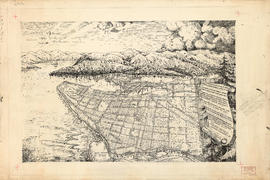
Pictorial map of Greater Vancouver
Part of City of Vancouver Archives technical and cartographic drawing collection
Part contains an illustrated map (not drawn to scale) of Vancouver and the surrounding area and a celebratory poem. An annotation at the edge of the drawing proposes inverting two lines of the poem.

Street map of Greater Vancouver, B.C.
Part of City of Vancouver Archives technical and cartographic drawing collection
Part contains a map of Greater Vancouver showing highways, streets, parks, golf courses and country clubs, institutions, block numbers, city and municipal boundaries and Shell marine stations.

Transit system map of Greater Vancouver, B.C.
Part of City of Vancouver Archives technical and cartographic drawing collection
Part contains a map of Greater Vancouver showing bus lines, route numbers, B.C. Electric installations, block numbers, points of interest and amenities; an inset map showing streets in Gleneagles, Whytecliff, and Horseshoe Bay; and an inset map showing streets in Port Moody, Coquitlam, and Maillardville.