Print preview Close

Showing 123 results

Archival description
City of Vancouver Archives technical and cartographic drawing collection
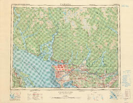
 Greater Vancouver (B.C.)
Print preview View:

58 results with digital objects Show results with digital objects

Greater Vancouver and Fraser Valley

Item is a pamphlet containing a map of Greater Vancouver and the Fraser Valley on one side and text promoting British Columbia and the services of Western Development and Power Limited on the other. Map shows the B.C. Electric railway line within the Greater Vancouver and Fraser Valley area, other railway lines, main roads, municipal boundaries, industrial sites, airports and ports. An inset map shows the total area served by B.C. Electric within British Columbia and the location of Greater Vancouver and the Fraser Valley within that area.

Metropolitan areas of Vancouver and Victoria, B.C. road map

Item is road map designed to be folded into a pamphlet and containing three maps showing streets in Greater Vancouver, major roads from the North Shore to Bellingham, Washington, and major roads in and around Victoria. Item also includes information about traffic rules in Vancouver and the use of the imperial gallon in British Columbia.

Western Canada

Item is a two-sided road map containing a map of Saskatchewan, Manitoba and the adjoining U.S. states; a map showing Canada and the United States from Labrador and Prince Rupert, B.C. in the north to Richmond, Virginia and San Francisco, California in the south; a map of British Columbia and Alberta; and an illustrated map of Greater Vancouver. The item includes road indexes, a mileage chart for Western Canada, and information on national parks in Western Canada.

Indexed guide map of the city of Vancouver and suburbs

Part is a map showing district lots, blocks, and boundaries between the City of Vancouver, Point Grey, South Vancouver, Burnaby, New Westminster, and parts of Richmond, North Vancouver and West Vancouver. Concentric circles indicate the distance in miles from the intersection of Main Street and Hastings Street in intervals of 1/2 mile.

Map of Vancouver, Burnaby, New Westminster, British Columbia : street index and advertisements

Part contains a street index for the main map of Vancouver on the other side of the sheet, advertisements for Bekins Moving and Storage and Allied Van Lines, and three maps showing the companies' service areas in the United States, Canada, and British Columbia and Alberta. An annotation reads: "Oppenheimer collection."

Greater Vancouver and Fraser Valley

Part contains a map showing the B.C. Electric railway line within the Greater Vancouver and Fraser Valley area, other railway lines, main roads, municipal boundaries, industrial sites, airports and ports. An inset map shows the total area served by B.C. Electric within British Columbia and the location of Greater Vancouver and the Fraser Valley within that area.

Vancouver, British Columbia

Part contains a map of the Greater Vancouver area showing topographic contour lines at 500-foot intervals, roads and road characteristics, railways, parks, towns, reserves, elevations, airports, streams, lakes, and adminstrative boundaries. Includes a key plan of adjoining sheets published in the same series and a small ancillary map showing the declination of the compass needle in 1958.

B.C. Electric guide to Greater Vancouver : Richmond transit system, downtown Vancouver transit system, street index, and general information

Part contains maps of the Richmond and downtown Vancouver transit systems, a street index to the Greater Vancouver map on the other side of the sheet, information on B.C. Electric transit routes, and general tourist information.

Results 1 to 50 of 123