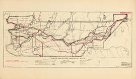
3400 regional series - reference schedule AA - flood plains
- AM1257-S26-F18-35
- File
- [197-]
39 results with digital objects Show results with digital objects
3400 regional series - reference schedule AA - flood plains
B.C. Hydro and Power Authority natural gas pipelines

British Columbia : Port Moody sheet : west of seventh, east and west of coast meridians
Part of City of Vancouver Archives technical and cartographic drawing collection
Item is a map of the Lower Mainland of British Columbia, from the international border in the south to Britannia Beach in the north and from Sechelt Peninsula in the west to Chilliwack and Harrison Lake in the east. Map shows railways, railway stations, trails, roads surveyed, post offices, townships, and ranges.

Part of City of Vancouver Archives technical and cartographic drawing collection
Item is a map showing subdivisions of townships in Coquitlam, Port Moody, Pitt Meadows, Surrey, Langley, Sumas, Sardis and Chilliwack. The west coast of British Columbia from Burrard Inlet to the Sechelt peninsula is shown as well as Vancouver Island and the surrounding Gulf Islands. Trails, post offices and railway stations are included.
Composite industrial map of metropolitan area : Lower Mainland, British Columbia
Item is a map showing railroads, main traffic arteries, new housing developments, lot numbers, municipal boundaries and industrial areas in Vancouver, West Vancouver, North Vancouver, Coquitlam, Delta, Richmond and Surrey. Industrial areas are categorised according to the following: existing heavy industry, potential heavy industry, existing light industry and potential light industry. The item also includes a breakdown of industrial areas by acreages.
Composite industrial map of the metropolitan area, Lower Mainland, British Columbia
Part of City of Vancouver Archives technical and cartographic drawing collection
Item is a map showing areas either occupied by industry or zoned for industry in the following municipalities of the Lower Mainland: Vancouver, New Westminster, North Vancouver, Port Coquitlam, Port Moody, Burnaby, Coquitlam, Delta, North Vancouver, Richmond, Surrey and West Vancouver. Industrial areas are categorized as either light or heavy industry. New housing developments, main traffic arteries, railways and municipal boundaries are also indicated.
Composite industrial map of the metropolitan area, Lower Mainland, British Columbia

Development in the western portion of the Lower Mainland region, 1968
Part of City of Vancouver Archives technical and cartographic drawing collection
Item is a map showing residential, commercial, industrial, civic and institutional, parks and recreational and agricultural zoning in the Lower Mainland area, including West Vancouver, North Vancouver, Vancouver, Burnaby, Coquitlam, New Westminster, Richmond, Maple Ridge, Langley, Surrey, Delta and White Rock. Information has been added to a base map published by the Province of British Columbia.
Electric and gas transmission lines rights of way

Enjoyable trips on our interurban lines
Part of City of Vancouver Archives technical and cartographic drawing collection
Part contains text advertising the British Columbia Electric Railway Company's interurban lines.
Enumeration areas : 1966 census
Fishing guide to Lower Mainland waters
Fraser River and Burrard Inlet
Fraser River and Burrard Inlet
Part of City of Vancouver Archives technical and cartographic drawing collection
Item is a nautical chart which show details of the area surveyed from Pitt Lake in the north to Roberts Bank in the south and from (what is now) Harrison Hot Springs in the east to Bowen Island in the west. The chart shows soundings in Burrard Inlet, and along the Fraser River.

Fraser River Delta, British Columbia
Part of City of Vancouver Archives technical and cartographic drawing collection
Item is a map of the Fraser River and Lower Mainland showing the following: roads, electric railways and tramways, bridges, churches, schools, post offices, cemeteries, international, municipal, township and city boundaries, wharves, lighthouses, triangulation stations and boundary monuments. Map gives topography of the land and shows water lines, tidal flats and intermittent streams.

Part of City of Vancouver Archives technical and cartographic drawing collection
Item is a map showing railway freight lines and stops from North Vancouver in the north through northern Washington in the south, and from Chilliwack in the east to Steveston in the west.

Map shows boundaries, lot numbers and major roads in Greater Vancouver (including West Vancouver, North Vancouver, the City of North Vancouver, the City of Vancouver, Coquitlam, Point Grey, South Vancouver, Burnaby, New Westminster, Port Moody, Port Coquitlam, Pitt Meadows, Surrey, Langley, Delta and Richmond).
Greater Vancouver/upper Fraser Valley
Part of City of Vancouver Archives technical and cartographic drawing collection
Item is a topographic map in two sections showing British Columbia north of Burrard Inlet to Britannia Creek in the north, and from Howe Sound in the west to Indian Arm in the east. Map shows lakes, streams and other natural features; roads, railways, communication lines, cities and other built features; and land, timber, and mineral surveys by number.
![Howe Sound - Burrard Inlet [Burrard Inlet portion]](/uploads/r/null/f/8/5/f8523992bb5d5e0c1391f2dea183041a54a2d2470eb4047bb29958a0d835ae95/fdf9563d-923e-468a-a494-3ff190294b91-MAP30b_142.jpg)
Howe Sound - Burrard Inlet [Burrard Inlet portion]
Part of City of Vancouver Archives technical and cartographic drawing collection
Part shows the Lower Mainland and Burrard Inlet from Howe Sound in the west to Indian Arm in the east. Map shows topographic contour lines, elevations, lakes, streams and other natural features, roads, railways, communication lines, cities and other settlements, and land, timber, and mineral surveys by number. Includes a list of sources of information.

Hydro electric surveys. Plan showing location of water powers investigated by City of Vancouver
Part of City of Vancouver fonds
Item is a map which shows the locations and the dates of use of "gauging stations established" and "city gauging stations still in use" in the area of south-western British Columbia where the City of Vancouver conducted hydro-electric surveys up to 1923.

Hydro electric surveys. Plan showing location of water powers investigated by City of Vancouver
Part of City of Vancouver fonds
Item is a map which functions as a visual index to the locations of various hydro electric surveys carried out by the City of Vancouver along the following rivers: Squamish River, Cheakamus River, Green River, Lillooet River, Eagle River, Indian River, Pitt River, Chehalis River, Harrison River, Chilliwack River, the Fraser and Thompson Rivers, and Bridge River. The map lists the names of the surveyors responsible and the areas covered by each survey. Annotations include the locations and the dates of use of "gauging stations established" and "city gauging stations still in use."
Indian Reserve with list of population size
Long-range plan : preliminary working draft
Lower Fraser Valley region : municipal population growth 1921-49

Lower Mainland municipalities with planning departments 1962
Part of City of Vancouver fonds
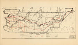
Lower Mainland Regional Plan : base map
Part of Community Planning Association of Canada, British Columbia Division fonds
Item is a map showing city, municipal district, provincial, and regional plan boundaries, trunk highways, main roads, railways, airports, customs ports, and historical monuments. Item is the base map for the other Lower Mainland Regional Plan maps in the file.

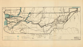
Lower Mainland Regional Plan : dykes
Part of Community Planning Association of Canada, British Columbia Division fonds
Lower Mainland Regional Plan : harbour areas
Part of Community Planning Association of Canada, British Columbia Division fonds
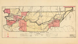
Lower Mainland Regional Plan : land use
Part of Community Planning Association of Canada, British Columbia Division fonds

Lower Mainland Regional Plan : light and power distribution
Part of Community Planning Association of Canada, British Columbia Division fonds
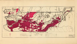
Lower Mainland Regional Plan : population distribution
Part of Community Planning Association of Canada, British Columbia Division fonds
Lower Mainland Regional Plan : telephones
Part of Community Planning Association of Canada, British Columbia Division fonds

Lower Mainland Regional Plan : water supply
Part of Community Planning Association of Canada, British Columbia Division fonds
Lower Mainland regional series