Add to clipboard
North America. West Coast. Fraser River and Burrard Inlet
Add to clipboard
North America. West Coast. Fraser River and Burrard Inlet
Add to clipboard
Lower Mainland, B.C. : land subdivision
Add to clipboard
Plan 3
Add to clipboard
Map of New Westminster District, B.C.
Add to clipboard
Map and information concerning the City and District of New Westminster and Province of British Columbia
Add to clipboard
Map of the municipalities of New Westminster City and District, British Columbia
Add to clipboard
Map of Vancouver, New Westminster, Steveston and the Lower Mainland District
Add to clipboard
British Columbia. Port Moody
Add to clipboard
Map of the Lower Mainland showing municipal boundaries and lot numbers
Add to clipboard
Enjoyable trips on our interurban lines
Add to clipboard
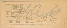
Plan showing locations of oil and gas seepages and oil wells in Fraser Valley, British Columbia
Add to clipboard
Plan showing locations of oil and gas seepages and oil wells in Fraser Valley, British Columbia
Add to clipboard
Map showing route Vancouver to Mission
Add to clipboard
British Columbia : Port Moody sheet : west of seventh, east and west of coast meridians
Add to clipboard
Fraser River Delta, British Columbia
Add to clipboard
Howe Sound - Burrard Inlet [Burrard Inlet portion]
Add to clipboard
Freight lines : British Columbia Electric Railway Company Limited, Vancouver and Lulu Island Railway Company (Canadian Pacific Railway Company, Lessee)
Add to clipboard
Map of Fraser Valley
Add to clipboard
Development in the western portion of the Lower Mainland region, 1968
Add to clipboard
Vancouver : as seen from space : vue de l'espace


![Howe Sound - Burrard Inlet [Burrard Inlet portion]](/uploads/r/null/f/8/5/f8523992bb5d5e0c1391f2dea183041a54a2d2470eb4047bb29958a0d835ae95/fdf9563d-923e-468a-a494-3ff190294b91-MAP30b_142.jpg)


