Railroads of the Lower Mainland of British Columbia, 1882-1992
- AM1594-: MAP 1177
- Item
- 1992
Part of City of Vancouver Archives technical and cartographic drawing collection
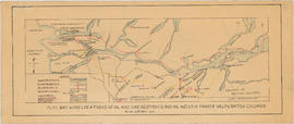
Primary map shows existing track, abandoned track, station buildings and bridges in the Greater Vancouver area from West Vancouver in the north to the United States border in the south and from Haney in the east to Horseshoe Bay in the west. Ancillary maps show details of Vancouver B.C.E., C.No.P., C.P. and G.N. railroad yards and New Westminster B.C.E., C.No.P., C.P. details. The item also includes a chronology of railroad subsidiaries, takeovers and mergers.