Showing 100 results

Archival description
Lower Mainland (B.C.)
Print preview View:

39 results with digital objects Show results with digital objects

Howe Sound - Burrard Inlet

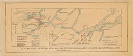
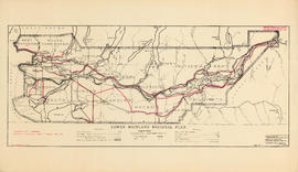
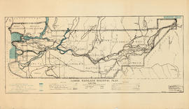
Item is a topographic map in two sections showing British Columbia north of Burrard Inlet to Britannia Creek in the north, and from Howe Sound in the west to Indian Arm in the east. Map shows lakes, streams and other natural features; roads, railways, communication lines, cities and other built features; and land, timber, and mineral surveys by number.

Greater Vancouver

Map shows boundaries, lot numbers and major roads in Greater Vancouver (including West Vancouver, North Vancouver, the City of North Vancouver, the City of Vancouver, Coquitlam, Point Grey, South Vancouver, Burnaby, New Westminster, Port Moody, Port Coquitlam, Pitt Meadows, Surrey, Langley, Delta and Richmond).

Map of Fraser Valley

Part consists of a map showing major roadways in the Lower Mainland and the Fraser Valley from Vancouver to Chilliwack, and lists of Vancouver businesses, schools, public buildings, hospitals, bathing beaches, fire halls, and golf and country clubs. Part includes text advertising the products and services of the Dominion Map and Blueprint Company.

Map of the municipalities of New Westminster City and District, British Columbia

Part contains a map of the Lower Mainland and Fraser Valley from the Gulf of Georgia in the west to Harrison Lake in the east. Map shows locations of churches, schools, canneries, sawmills, brickyards, tanneries, woolen mills and hatcheries; existing and proposed railways; and roadways.

Howe Sound - Burrard Inlet [Burrard Inlet portion]

Part shows the Lower Mainland and Burrard Inlet from Howe Sound in the west to Indian Arm in the east. Map shows topographic contour lines, elevations, lakes, streams and other natural features, roads, railways, communication lines, cities and other settlements, and land, timber, and mineral surveys by number. Includes a list of sources of information.

Fraser River Delta, British Columbia

Item is a map of the Fraser River and Lower Mainland showing the following: roads, electric railways and tramways, bridges, churches, schools, post offices, cemeteries, international, municipal, township and city boundaries, wharves, lighthouses, triangulation stations and boundary monuments. Map gives topography of the land and shows water lines, tidal flats and intermittent streams.

British Columbia : Port Moody sheet : west of seventh, east and west of coast meridians

Item is a map of the Lower Mainland of British Columbia, from the international border in the south to Britannia Beach in the north and from Sechelt Peninsula in the west to Chilliwack and Harrison Lake in the east. Map shows railways, railway stations, trails, roads surveyed, post offices, townships, and ranges.

Sectional map and street directory of Vancouver : Dial map of the city of Vancouver including adjacent municipalities

Item is a street map showing Vancouver, Burnaby, New Westminster, West Vancouver, and North Vancouver on one side and the Lower Mainland from Vancouver to Chilliwack on the other. Item includes lists of businesses, schools, public buildings, hospitals, bathing beaches, fire halls, and golf and country clubs, as well as text advertising the products and services of the Dominion Map and Blueprint Company.

Map of Fraser Valley

Part consists of a street map of the Lower Mainland and Fraser Valley from Vancouver to Chilliwack, a street map of New Westminster, a map of Vancouver and North Vancouver showing street names but not street lines, and text advertising the products and services of the Dominion Map and Blueprint Company.

Sectional map and street directory of Vancouver : Dial map of the city of Vancouver including adjacent municipalities

Item is a street map showing Vancouver, Burnaby, New Westminster, West Vancouver, and North Vancouver on one side and the Lower Mainland from Vancouver to Chilliwack on the other. Item includes lists of businesses, schools, public buildings, hospitals, bathing beaches, fire halls, and golf and country clubs, as well as text advertising the products and services of the Dominion Map and Blueprint Company.

Vancouver. Lower Mainland

Item is a map made as a composite of scaled aerial photographs of the Lower Mainland. The photograph's boundaries are: the westernmost extent of the area covered is Passage Island in Horseshoe Bay; the easternmost is 216st Street, Maple Ridge; the northernmost is Lynn Headwaters Regional Park; and the southernmost is Drayton Harbour, Surrey.

McEllanney Surveying and Engineering

Composite industrial map of the metropolitan area, Lower Mainland, British Columbia

Item is a map showing areas either occupied by industry or zoned for industry in the following municipalities of the Lower Mainland: Vancouver, New Westminster, North Vancouver, Port Coquitlam, Port Moody, Burnaby, Coquitlam, Delta, North Vancouver, Richmond, Surrey and West Vancouver. Industrial areas are categorized as either light or heavy industry. New housing developments, main traffic arteries, railways and municipal boundaries are also indicated.

Composite industrial map of metropolitan area : Lower Mainland, British Columbia

Item is a map showing railroads, main traffic arteries, new housing developments, lot numbers, municipal boundaries and industrial areas in Vancouver, West Vancouver, North Vancouver, Coquitlam, Delta, Richmond and Surrey. Industrial areas are categorised according to the following: existing heavy industry, potential heavy industry, existing light industry and potential light industry. The item also includes a breakdown of industrial areas by acreages.

Plan showing locations of oil and gas seepages and oil wells in Fraser Valley, British Columbia

Item is a map which shows rivers and streams, oil and gas seepages, oil wells drilled, towns and villages and railway lines from Pitt Lake in the north to the United States border in the south and from Chilliwack in the east to the Strait of Georgia in the west.

Haggen, E.A.

Metropolitan area, Lower Mainland, British Columbia [Analysis of major suburban commercial centres - 1976]

Item is a map of the Lower Mainland showing metropolitan, suburban, and district commercial centres, primary population catchment areas, and 1955 and projected 1976 populations for areas within a three-mile radius from a suburban commercial centre. The base map is a topographical map compiled by the Technical Committee for Metropolitan Highway Planning in 1955 and shows property divisions, roads, and buildings.

Rights of way Vancouver and vicinity

Item is a portion of a topographical map of the Lower Mainland which has been extensively annotated to show the routes and rights-of-way of the various railways running through the region.

The lines shown are: Canadian Pacific Railway, Canadian National Railway, Great Northern Railway, B.C. Electric Railway, Canadian Pacific Railway operated by B.C. Electric Railway, Canadian Pacific Railway joint operation with National Harbours Board Terminal Railway, Great Northern Railway joint operation with National Harbours Board Terminal Railway, Great Northern Railway joint operation with Canadian National Railway, National Harbours Board Terminal Railway and Canadian Pacific Railway tunnel and Pacific Great Eastern Railway lease to National Harbours Board.

Development in the western portion of the Lower Mainland region, 1968

Item is a map showing residential, commercial, industrial, civic and institutional, parks and recreational and agricultural zoning in the Lower Mainland area, including West Vancouver, North Vancouver, Vancouver, Burnaby, Coquitlam, New Westminster, Richmond, Maple Ridge, Langley, Surrey, Delta and White Rock. Information has been added to a base map published by the Province of British Columbia.

Results 1 to 50 of 100