- AM1594-: MAP 750-: LEG1318.3
- Part
- [ca. 1909]
Part of City of Vancouver Archives technical and cartographic drawing collection
11 results with digital objects Show results with digital objects
Part of City of Vancouver Archives technical and cartographic drawing collection
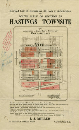
Revised list of remaining 50 lots in subdivision of south half of section 35, Hastings Townsite
Part of City of Vancouver Archives technical and cartographic drawing collection
Part contains a map showing lots for sale in the area bounded by Slocan Street, Renfrew Street, 9th Avenue, and 13th Avenue, and textual information for potential buyers. Annotations indicate which lots were sold.

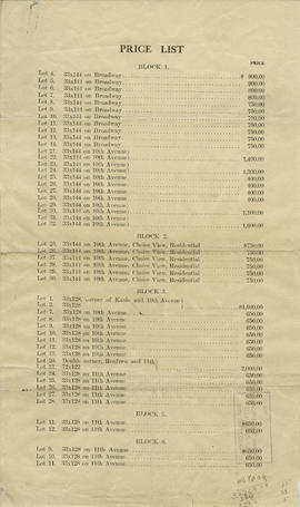
Price list of new subdivision : Hastings Townsite, close to city limits
Part of City of Vancouver Archives technical and cartographic drawing collection
Part contains a price list and map showing lots in the area bounded by Slocan Street, Renfrew Street, 9th Avenue, and 12th Avenue. Annotations indicate different prices than those listed.

Hastings Townsite : Nanaimo Street to Renfrew Street and Burrard Inlet to Cambridge Street
Part of City of Vancouver Archives technical and cartographic drawing collection
Part is a sheet of a sectional map of Hastings Townsite showing streets, railways, legal addresses, some lot sizes, and municipal boundaries. Item has been annotated with information regarding property ownership and various symbols of unspecified meaning.

Hastings Townsite : Rupert Street to Boundary Road and Pender Street to Charles Street
Part of City of Vancouver Archives technical and cartographic drawing collection
Part is a sheet of a sectional map of Hastings Townsite showing streets, railways, legal addresses, some lot sizes, and municipal boundaries. Item has been annotated with information regarding property ownership and various symbols of unspecified meaning.

Hastings Townsite : Renfrew Street to Rupert Street and 5th Avenue to 13th Avenue
Part of City of Vancouver Archives technical and cartographic drawing collection
Part is a sheet of a sectional map of Hastings Townsite showing streets, railways, legal addresses, some lot sizes, and municipal boundaries. Item has been annotated with information regarding property ownership, including identification of properties included in a 1919 tax sale, and various symbols of unspecified meaning.

Hastings Townsite : Rupert Street to Boundary Road and 5th Avenue to 13th Avenue
Part of City of Vancouver Archives technical and cartographic drawing collection
Part is a sheet of a sectional map of Hastings Townsite showing streets, railways, legal addresses, some lot sizes, and municipal boundaries. Item has been annotated with information regarding property ownership, including identification of properties included in a 1919 tax sale, and various symbols of unspecified meaning.

Part of City of Vancouver Archives technical and cartographic drawing collection
Part is a sheet of a sectional map of Hastings Townsite showing streets, railways, legal addresses, some lot sizes, and municipal boundaries. Item has been annotated with information regarding property ownership and various symbols of unspecified meaning.