
- AM1399-S3---: CVA 1399-591
- Item
- 1928
Item is a photograph of apartment building exterior. Building is located at 1311 Beach Ave. at Jervis St., Vancouver B.C.
Item is a photograph of apartment building exterior. Building is located at 1311 Beach Ave. at Jervis St., Vancouver B.C.

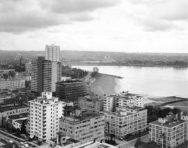
View of English Bay beach and bathhouse, with West End high rise buildings in background
View of Sunset Beach and Crystal Pool, with West End highrise buildings in background

English Bay beach, showing renovated bathhouse

View of Coast Guard station and floating gas station with West End highrise apartments in background

View of English Bay beach, looking west toward Stanley Park, showing Englesea Lodge
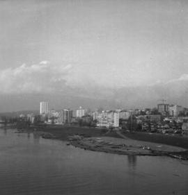
Bird's eye view of West End buildings, English Bay Beach and west shore of English Bay
Item is a photograph inscribed "English Bay spring 65".

View of English Bay beach, Englesea Lodge and West End building

View of English Bay beach from Stanley Park

Youngsters parading on Denman Street near Bay Theatre
Part of City publications collection
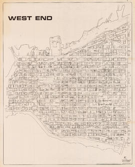
Item is a map showing streets, building footprints, number of storeys, topographic contour lines, and street codes according to a system adopted by the Engineering Department in the mid-1960s.

Part of City publications collection
Item is a map showing streets, building footprints and number of storeys.

Households and population by enumeration areas : 1966 census
Part of City of Vancouver fonds
Item is a map annotated to show households and population for the West End and downtown core east to Main Street. Base map shows streets.

A cappella group performing at Denman Mall in front of Centennial display

Centennial display at Denman Mall

A cappella group performing at Denman Mall in front of Centennial display

Vancouver City of the Century Cake

Tillicum with group of children at Denman Mall

Tillicum posing with woman at the West End Community Centre's Fun and Wellness Festival

West end homes, west side of Burrard Street
![1531 Davie Street, Gabriola [house]](/uploads/r/null/8/1/d/81d2dcaa6208d08c5db985d5671f22efd9bc3ecb4c48c780b2df4a698d644bcc/6b797b94-1e82-4b35-8b3a-83e781678074-2011-010_142.jpg)
1531 Davie Street, Gabriola [house]
![Gabriola [house at 1531 Davie Street]](/uploads/r/null/a/4/0/a4014f434760c657755dc0906d1b06e19c56fb50baf0b9945c12d36a0911d3fb/f57ef277-b2f0-43e3-a758-22883d97cb29-2011-010_142.jpg)
Gabriola [house at 1531 Davie Street]

Girl on horse in front of Gabriola house at 1531 Davie Street
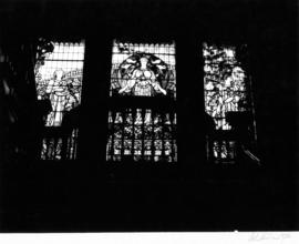
Angus Apartments (Gabriola), 1531 Davie Street, stained glass
Part of Art Grice fonds
Item is a photograph of the stained glass window at a landing of the main stairs inside of The Angus Apartments (formerly B.T. Rogers home, also known as Gabriola, 1531 Davie Street).
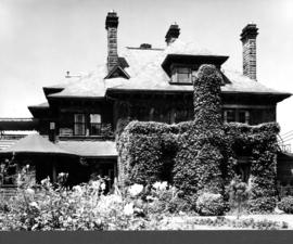
Angus Apartments (Gabriola), 1531 Davie Street, east facade
Part of Art Grice fonds
Item is a photograph of the east facade of The Angus Apartments (formerly B.T. Rogers home, also known as Gabriola, 1531 Davie Street). Detail of topiary and front garden is also visible in front of the house.
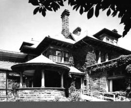
Angus Apartments (Gabriola), 1531 Davie Street, east facade and gazebo
Part of Art Grice fonds
Item is a photograph of the east facade and gazebo of The Angus Apartments (formerly B.T. Rogers home, also known as Gabriola, 1531 Davie Street).

Angus Apartments (Gabriola), 1531 Davie Street, dormer window
Part of Art Grice fonds
Item is a photograph of the hip roof dormer window on the east facade of The Angus Apartments (formerly B.T. Rogers home, also known as Gabriola, 1531 Davie Street).

Angus Apartments (Gabriola), 1531 Davie Street, porte-cochere ceiling and frieze
Part of Art Grice fonds
Item is a photograph of the frieze and coffered ceiling of the porte-cochere at The Angus Apartments (formerly B.T. Rogers home, also known as Gabriola, 1531 Davie Street).

Angus Apartments (Gabriola), 1531 Davie Street, front entrance
Part of Art Grice fonds
Item is a photograph of the front entrance doors and the entry room of The Angus Apartments (formerly B.T. Rogers home, also known as Gabriola, 1531 Davie Street).

Angus Apartments (Gabriola), 1531 Davie Street, porte-cochere and garden
Part of Art Grice fonds
Item is a photograph of the porte-cochere at The Angus Apartments (formerly B.T. Rogers home, also known as Gabriola, 1531 Davie Street), the pathway leading up to it, the surrounding lawns and gardens, and part of the south face of the building, including another dormer window.

Angus Apartments (Gabriola), 1531 Davie Street, fireplace
Part of Art Grice fonds
Item is a photograph of a terra cotta sculpted fireplace, mantle, and overmantle inside The Angus Apartments (formerly B.T. Rogers home, also known as Gabriola, 1531 Davie Street).

Angus Apartments (Gabriola), 1531 Davie Street, staircase
Part of Art Grice fonds
Item is a photograph of a large staircase with landings inside The Angus Apartments (formerly B.T. Rogers home, also known as Gabriola, 1531 Davie Street).
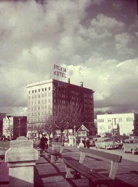
Item is a photograph of the southwest (front) and southeast (side) facades of the Sylvia Hotel (Beach Avenue at Gilford Street) with a section of park benches in the foreground. The photograph was taken from park area on the Beach Avenue, looking north. Cars parked and other park visitors can be seen in the photograph.
Part of City of Vancouver fonds
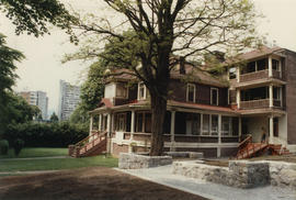
Barclay Manor at 1433 Barclay Street
Part of City of Vancouver fonds
![Fountain at Heritage Park Site 19 [Barclay Heritage Square]](/uploads/r/null/b/9/d/b9d7f3748f2336cbd4002ae12a60ec6e5533f890536eff09d37c7a714515da56/5a3725cd-a022-4fed-b95d-5cbf55d8e9b7-CVA775-22_142.jpg)
Fountain at Heritage Park Site 19 [Barclay Heritage Square]
Part of City of Vancouver fonds

Early phase of Barclay Heritage Square restoration
Part of City of Vancouver fonds

Early phase of Barclay Heritage Square restoration
Part of City of Vancouver fonds
Part of City of Vancouver fonds
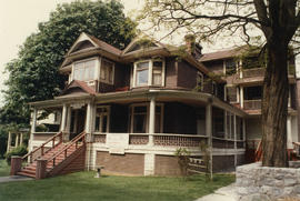
Barclay Manor at 1433 Barclay Street
Part of City of Vancouver fonds

Early stage of Roedde House restoration
Part of City of Vancouver fonds
![Vancouver, B.C. Plan showing location of water pipes, hydrants, etc. [West End]](/uploads/r/null/0/5/05354f71931ba85b05864a2adeb3580a6365ddf962e5084f0bb51c68608364a0/3f57f512-bd27-404e-a332-e0881405c2ac-MAP72_142.jpg)
Vancouver, B.C. Plan showing location of water pipes, hydrants, etc. [West End]
Part of City of Vancouver Archives technical and cartographic drawing collection
Item is a map showing the location of water pipes and hydrants for the West End west of Burrard Street. Pipes and hydrants are shown in various coloured inks to indicate date of installation. Annotations have been added to a base map which is a portion of a larger map.
Vancouver (B.C.). Water Works Department
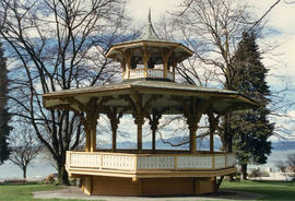
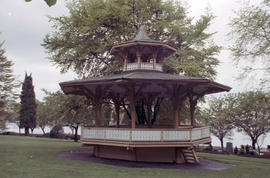
![Haywood [Alexandra] Bandstand and Legacy Program signboard](/uploads/r/null/8/4/2/842e5d81cb9db62c6f08bd22f4922c781995662ed02b4f35b331473978fc29cf/727cc703-e8b5-4308-8bee-b67b9ff85cc0-CVA775-166_142.jpg)
Haywood [Alexandra] Bandstand and Legacy Program signboard
Part of City of Vancouver fonds
Part of City of Vancouver fonds
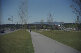
Item is a photograph showing a metal sculpture at the entrance to Stanley Park.

Denman Street at West Georgia Street
Part of City of Vancouver fonds
![Canadian Pacific map of Vancouver [west half]](/uploads/r/null/f/a/fa49266d21715d75ce93883012d471657dd058b90843927ec82b44d2bb42b007/f12ea9a5-4914-4db8-bda9-312aa2e2ccef-MAP10_142.jpg)
Canadian Pacific map of Vancouver [west half]
Part of City of Vancouver Archives technical and cartographic drawing collection
Item is a portion of a map depicting lands granted to the Canadian Pacific Railway in Vancouver. The portion depicts the West End and northern Kitsilano.

1000 block Nelson Street, Burrard-Thurlow, north side, view northwest
Part of City of Vancouver fonds

1200 block Nelson Street, Bute-Jervis, view west
Part of City of Vancouver fonds

1300 block Nelson Street, Jervis-Broughton, view southeast
Part of City of Vancouver fonds