Strait of Georgia and Strait of Juan de Fuca
- AM738-S1-: 1980-253.80
- Item
- 1964
7 results with digital objects Show results with digital objects
Strait of Georgia and Strait of Juan de Fuca
Part of City of Vancouver Archives technical and cartographic drawing collection
Item is a reproduction of a map of the Strait of Juan de Fuca, including the southern tip of Vancouver Island, the southern Gulf Islands and adjacent mainland, Admiralty Inlet and Puget Sound.

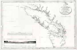
Vancouver Island and adjacent shores of British Columbia
Part of City of Vancouver Archives technical and cartographic drawing collection
Part of City of Vancouver Archives technical and cartographic drawing collection
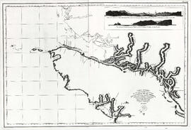
Item is a reproduction of a map depicting the Spanish explorations of the north-west coast of North American in 1795, specifically depicting the northern end of Vancouver Island and the adjacent mainland. Illustrations are views of the entrance to Nootka Sound, and a view of "Cabo Frondoso" (Cape Cook?).
Part of City of Vancouver Archives technical and cartographic drawing collection
Map shows the discoveries made in 1792 on the north-west coast of North American by examining Juan de Fuca Strait and the corresponding navigable channels, prepared for Dionisio Galiano and Captain Valdes, naval captains of the Royal (Spanish) Fleet in the year 1795.
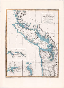
A chart shewing part of the coast of N.W. America
Part of City of Vancouver Archives technical and cartographic drawing collection
Item is a map, which is a coloured reproduction made in 1974 of one of the charts made in 1798 of George Vancouver's surveys of the Pacific coast of North America. The plate depicts the area from Cape Lookout, north to Cape Swain. The routes taken by Vancouver are marked. Inset map shows a survey of Port Stewart. Three inset maps show the entrance of the Columbia River, Port of Discovery and Gray's Harbour. The routes taken by Captain Vancouver are marked.
![[Cross sections of ocean floor between Vancouver Island and mainland of British Columbia]](/uploads/r/null/c/a/6/ca687b43e46696a0c1d9223ef1e80ebe50bba0ea48092c458b525fc90f7b517c/7d458083-64ae-4682-be03-8fd1211e38c9-MAP8b_142.jpg)
[Cross sections of ocean floor between Vancouver Island and mainland of British Columbia]
Part of City of Vancouver Archives technical and cartographic drawing collection
Item shows ocean floor cross sections at 49 degrees latitude, 48 degrees 45', 48 degrees 35', and 48 degrees 25'. Islands and other geographical features are indicated.
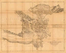
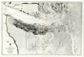
Map showing the line of boundary between the United States and British possessions
Part of City of Vancouver Archives technical and cartographic drawing collection
Item is a map showing four proposed boundaries between the United States and British possessions in the Salish Sea region. The explanations of the lines read in part: "[1] Boundary line contemplated by the Treaty as shown by contemporaneous evidence; [2] Boundary line as claimed by the British Commissioner; [3] Boundary line proposed by the British Commissioner as a compromise ( . . . ); [4] Boundary line in accordance with the strict letter of the Treaty ( . . . ). Item also shows soundings, and the "track of steamers plying between Victoria and Fraser river since discovery of gold."
Part of City of Vancouver Archives technical and cartographic drawing collection
Map shows Juan de Fuca Strait, the San Juan Islands and the southern portion of Vancouver Island.