
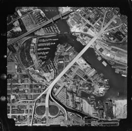
Aerial photo, vertical, False Creek, Fairview to Kits Point
- AM1376-: CVA 59-13
- Item
- May 1956
Item is a photograph of False Creek, showing English Bay to W 16th Avenue, and from Maple Street to the Cambie Street Bridge. Includes the Burrard Street Bridge, the new Granville Bridge, the Cambie Bridge, and Granville Island.


![[Aerial view of lumber yard fire on south shore of False Creek]](/uploads/r/null/3/2/0/3208cbc9d06338a92738b56e1cb989d6c70179caf44b699eb76f28dadbba5a99/0c03d83a-377f-47eb-bbde-90519d0ddcea-CVA354-411_142.jpg)


![[Centennial employees building stage platform]](/uploads/r/null/e/2/4/e24865cfb50a51f74063f522f8f70003e5c5c395cb904467babb850ad89e138d/f1c48b90-9d15-444b-8d78-725f6499c81a-2011-010_142.jpg)
![[Centennial employees building stage platform]](/uploads/r/null/2/0/7/207da9d16e9f9cc0fa9566d1ec7336e508d3ab85459f06f16fd4e8ff2647068c/d337295e-8417-4f0b-9f35-4eaa7dc9ff30-2011-010_142.jpg)
![[Centennial employees building stage platform]](/uploads/r/null/d/b/8/db8a974e6ab3b47a78c9a9d3370841bc645544299421d036723d79cd442cd169/5489b780-6b38-4420-91e3-9349471d0c9f-2011-010_142.jpg)


![False Creek development : san [sanitary] sewers tentative layout](/uploads/r/null/c/a/ca111eaa497f59a66ecdad4c91bfb2238f21efb21b91a1172f460ef16667055f/4da08847-7457-4d4c-8938-e4c6c1dc50c3-MAP692_142.jpg)

