
- COV-S280-: CVA 354-360.2
- Item
- [ca. 1970]
Part of City of Vancouver fonds
Part of City of Vancouver fonds

Part of City of Vancouver fonds

Part of City of Vancouver fonds
Item is a photograph showing the east end of False Creek. From just west of Columbia Street to just east of Main Street, West 2nd Avenue to Keefer Street. Includes the Georgia Viaduct and Dunsmuir Viaduct.

Part of City of Vancouver fonds
Item is a photograph showing a view of the seawall from Charleson Park.

Part of City of Vancouver fonds
Item is a photograph showing the marina looking northwest with the Burrard Bridge in the background.

Part of City of Vancouver fonds
Item is a photograph showing a view of the seawall from Charleson Park.

Part of City of Vancouver fonds
Item is a photograph showing a view of the seawall looking east from the 800 block of Millbank Street.

Part of City of Vancouver fonds
Item is a photograph showing the seawall at Millbank Street and Ferry Row.

Part of City of Vancouver fonds
Item is a photograph showing the view from the seawall at the 1500 block of Island Park Walk. Boats are also shown in Fishermen's Wharf.

Part of City of Vancouver fonds
Item is a photograph showing a the seawall and boats in the marina.

Part of City of Vancouver fonds
Item is a photograph showing a the seawall and boats in the marina.

Part of City of Vancouver fonds
Item is a photograph showing a close up view of the seawall.

Part of City of Vancouver fonds
Item is a photograph showing a close up view of the seawall.

Part of City of Vancouver fonds
Item is a photograph showing the seawall at Foundry Quay.

Part of City of Vancouver fonds
Item is a photograph showing the seawall and a partial view of housing along 1100 block of The Castings and Island Park Walk.
![[Spectators watching lumber yard fire on the south shore of False Creek]](/uploads/r/null/1/7/2/1722b2603bbd442ef4d97d5b072f496b7756fc4343ee887e6e46583f7edd8153/5d206ecf-19bb-4161-b31a-38aaa34f2216-CVA354-410_142.jpg)
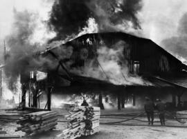
[Spectators watching lumber yard fire on the south shore of False Creek]
Part of City of Vancouver fonds
Item is a photograph showing a fire at Alberta Lumber Co. Ltd. at 790 West 6th Avenue.
Part of City of Vancouver fonds
Item is a photograph showing fire fighters working to control the blaze at the lumber mill site on West 6th Avenue.
![[View of fire at lumber yard - B.C. Forest Products fire?]](/uploads/r/null/9/b/b/9bb7b1121a5a4c910f4d3264b043a9f028cc0099a2b18e0f2606d798651b2662/edfdcb36-ab3c-4829-adf0-63aafb6fd88a-CVA354-416_142.jpg)
[View of fire at lumber yard - B.C. Forest Products fire?]
Part of City of Vancouver fonds
Item is a photograph showing fire fighters working to control the blaze at the lumber mill site on West 6th Avenue.
![Plan shewing location of sewers on C.P.Rly. [Canadian Pacific Railway] industrial sites](/uploads/r/null/7/6/1/7619e437193646086fba2c0b959aeb02c1226500076d36df8da8fa5f9e9388e9/b1d0ba23-309d-48e1-a012-2b2eb18a2ff8-MAP738_142.jpg)
Plan shewing location of sewers on C.P.Rly. [Canadian Pacific Railway] industrial sites
Part of City of Vancouver fonds
Item is a map showing location of sewers, businesses, and Canadian Pacific Railway buildings on the north side of False Creek from the Granville Street Bridge to the Cambie Street Bridge.
![False Creek development : san [sanitary] sewers tentative layout](/uploads/r/null/c/a/ca111eaa497f59a66ecdad4c91bfb2238f21efb21b91a1172f460ef16667055f/4da08847-7457-4d4c-8938-e4c6c1dc50c3-MAP692_142.jpg)
False Creek development : san [sanitary] sewers tentative layout
Part of City of Vancouver fonds
Item is a copy of a sheet from a sectional map of Vancouver which has been annotated to show the proposed locations of sanitary sewers in the area from Keefer Street in the north to 3rd Avenue in the south and from Clark Drive in the east to Ontario Street in the west.
Vancouver (B.C.). Engineer's Office

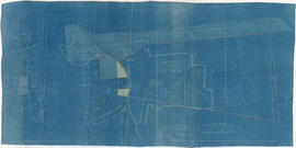
Plan showing vicinity of Fisher Case, Nov 9th, 1949
Part of City of Vancouver Archives technical and cartographic drawing collection
Item is a map showing roads, buildings, bridges and railway lines in the False Creek vicinity. Red pencil marks a route occupied by float houses and shacks. Green pencil marks an unidentified route on the map.
Vancouver (B.C.). Engineering Services

City of Vancouver, Canadian Pacific Town Site
Part of City of Vancouver Archives technical and cartographic drawing collection
The map shows the area currently occupied by Downtown Vancouver and parts of Kitsilano. It shows the location of C.P.R. Wharf, Royal City Saw Mills, Hastings Saw Mill and Wharf, Leamy and Kyle's Saw Mill and other saw mills. "Streets graded and side-walked marked thus . . . . .." An insert shows "Canadian Pacific Mail Steamship Lines" on a map of the world. The north shore of Burrard Inlet indicates the locations of "Indian Houses" and a mission church.

Tourist guide map of Vancouver City and Park
Part of City of Vancouver Archives technical and cartographic drawing collection
The map shows the area currenlty occupied by Downtown Vancouver and parts of Kitsilano. It shows the location of C.P.R. Wharves, Hastings Saw Mill and other saw and shingle mills. "Note, Electric street railway shewn in Red."

False Creek development survey occupation plan
Item is a copy of a City of Vancouver Engineer's Office map of the False Creek area from Walnut Street to Main Street and downtown to Sixth Avenue. Map shows streets, railway lines, names of businesses occupying sites on the waterfront, and former high tide waterlines.
Part of Elizabeth Walker fonds
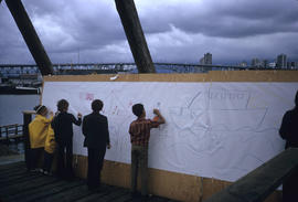
Item is a photograph showing children on False Creek tour drawing on paper. Written on slide: "filling in impressions of what future should be for area."

Tugboats and buildings along False Creek
Part of Elizabeth Walker fonds
Item is a photograph showing tugboats and buildings along False Creek. Photo taken during a tour of False Creek.
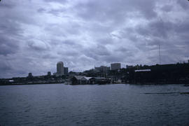
View from False Creek tour looking south-east from near Granville Street Bridge
Part of Elizabeth Walker fonds

Youth skateboarding outside of Isadora's
![[Centennial employees building stage platform]](/uploads/r/null/d/b/8/db8a974e6ab3b47a78c9a9d3370841bc645544299421d036723d79cd442cd169/5489b780-6b38-4420-91e3-9349471d0c9f-2011-010_142.jpg)
[Centennial employees building stage platform]
Chevron stage beside Isadora's underneath Granville Street Bridge

Woman wearing clown costume beside Chevron stage

Clowns holding gelatin model on stage at Fool's Day Parade

Unicyclist at Fool's Day Parade

Woman on stilts at Fool's Day Parade

Performers on stage at Fool's Day Parade

Tillicum in front of the Expo Centre

Tillicum in front of the Expo Centre

Tillicum in front of the Expo Centre

Tillicum in front of the Expo Centre

Tillicum in front of the Expo Centre

Tillicum in front of the Expo Centre

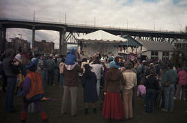
Performance celebrating Vancouver Day at the Expo Site

Fire Department Band performing at the Expo Site for Vancouver Day

View of Expo Site from boat cruise

Stage performance for Yokohama Day at Expo Site

Yokohama Day stage at Expo Site
![Low tide, False Creek [view of West End and snow capped mountains]](/uploads/r/null/e/0/e/e0e5503cf3dbf0703e6c476236df2aa98d0d46e31ab90c7a8b6d2f10c5fce160/fa968d94-288b-48e2-9a11-4dc65f5bc5a0-CVA293-014_142.jpg)
Low tide, False Creek [view of West End and snow capped mountains]
Part of William McNeill fonds
Item is a survey plan showing the layout of buildings on a section of reclaimed land where Carrall Street meets False Creek, and property ownership in adjacent areas. An index plan shows the location covered by the main map in relation to the surrounding area.

Corinne Lee posing with a car at Granville Island
Part of Paul Yee fonds
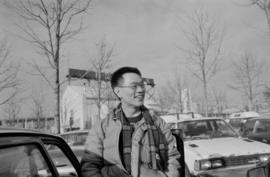
Paul Yee at a parking lot at Granville Island
Part of Paul Yee fonds