
- COV-S597-F1-: 2019-102.02
- Item
- July 1973
Part of City of Vancouver fonds
Part of City of Vancouver fonds

Part of City of Vancouver fonds
Item is a photograph showing a City plaque for the False Creek Shoreline project.

Part of City of Vancouver fonds
Item is a photograph showing the seawall under construction.

Part of City of Vancouver fonds
Item is a photograph showing the seawall under construction.

Part of City of Vancouver fonds

Part of City of Vancouver fonds
Item is a photograph showing buildings and roadwork under construction.
Part of City of Vancouver fonds
Item is a photograph showing a view of an area of the seawall between Stamp's Landing and Cambie Bridge (street unnamed).

Part of City of Vancouver fonds
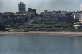
Item is a photograph showing a view of the seawall from Charleson Park.

Part of City of Vancouver fonds
Item is a photograph showing a view of the seawall from Charleson Park.

Part of City of Vancouver fonds
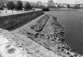
Item is a photograph showing a close up view of the seawall.

Part of City of Vancouver fonds
Item is a photograph showing a close up view of the seawall.

Part of City of Vancouver fonds
Item is a photograph showing the seawall at Millbank Street and Ferry Row.

Part of City of Vancouver fonds
Item is a photograph showing the view from Anderson Street at Granville Island looking west towards the 1500 block of Island Park Walk. Boats are also shown in Fishermen's Wharf.

Part of City of Vancouver fonds
Item is a photograph showing the seawall at 1000-1100 Ironwork Passage. BC Place is visible in the background.

Part of City of Vancouver fonds
Item is a photograph showing the seawall and a partial view of housing along 1100 block of The Castings and Island Park Walk.
Island Park Walk along False Creek
Part of City of Vancouver fonds

Island Park Walk along False Creek
Part of City of Vancouver fonds

Part of City of Vancouver fonds
Item is a photograph showing fire fighters working to control the blaze at the lumber mill site on West 6th Avenue.

Part of City of Vancouver fonds
Item is a photograph showing fire fighters working to control the blaze at the lumber mill site on West 6th Avenue.

Part of City of Vancouver fonds
Part of City of Vancouver fonds

Part of City of Vancouver fonds
Item is a map annotated to show amendments to the layout of False Creek Park. Map shows streets, drainage, elevations of fill, park boundaries, and proposed street extensions in the area bounded by Heatley Avenue, Glen Drive, Prior Street, and the Great Northern Railway lands. Base map extends to Main Street in the west.

Plan of sea wall site, Main Street, and surrounding properties
Part of City of Vancouver fonds
Item is a map showing sewers, pier headlines, land ownership, streets, parks and rail lines in the area east of False Creek at Main Street and Terminal Avenue.
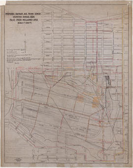
Proposed Raymur Ave. trunk sewer diverting sewage from False Creek reclaimed area
Part of City of Vancouver fonds
Item is a map showing detailed plans associated with the Raymur Ave. trunk sewer. The map contains several revisions and updates dated Dec. 1936, Feb. and Mar. 1937, May 1937, Aug. 1938 and Sept. 1941 of utilities infrastructure in False Creek east of Main Street.
Vancouver (B.C.). Engineer's Office

Proposed Raymur Ave. trunk sewer diverting sewage from False Creek reclaimed area
Part of City of Vancouver fonds
Item is a map showing detailed plans associated with the Raymur Ave. trunk sewer. Annotations show the heights of top fill, bottom and water relative to an unidentified benchmark.
Vancouver (B.C.). Engineer's Office

Proposed Raymur Ave. trunk sewer diverting sewage from False Creek reclaimed area
Part of City of Vancouver fonds
Item is a map showing detailed plans associated with the Raymur Ave. trunk sewer. Annotations show sewer lines.
Vancouver (B.C.). Engineer's Office

Tillicum in front of the Expo Centre
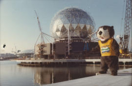
Tillicum in front of the Expo Centre

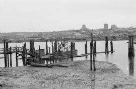
Boathouse Shacktown, False Creek
![[Centennial employees building stage platform]](/uploads/r/null/e/2/4/e24865cfb50a51f74063f522f8f70003e5c5c395cb904467babb850ad89e138d/f1c48b90-9d15-444b-8d78-725f6499c81a-2011-010_142.jpg)
[Centennial employees building stage platform]

Unidentified man in costume speaking into microphone on Chevron stage

Crowd assembled around Chevron Stage during Fool's Day event

People assembled around Chevron Stage during Fool's Day event
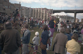
Crowd assembled around Chevron Stage during Fool's Day event
![Ripples on [the water at] False Creek](/uploads/r/null/9/e/5/9e53e82111d0ddf9987cda99b11b7dfdc9b96abc1ccb902c67a51ad986df1abc/6e67b7f7-47c4-4e04-b58d-c55de70a1965-CVA293-028_142.jpg)
Ripples on [the water at] False Creek

View of Expo Site from boat cruise

Performance for Yokohama Day at Expo Site

Centennial stage at Fool's Day Parade

Children watching person blowing bubbles at Fool's Day Parade

Performer on stilts wearing "Miss Expoo" sash at Fool's Day Parade

Part of City of Vancouver Archives technical and cartographic drawing collection
Item is a map showing street names and major landmarks around False Creek during Expo 86. Major pavilions on the fair site are labeled. An index map in the lower right-hand corner of the map shows the location of the primary map in relation to the rest of Greater Vancouver and the United States. The map also includes a short chronology of the history of False Creek and Granville Island. The cover of the envelope depicts a smaller version of the map.

Aerial photo, vertical, False Creek, Fairview to Kits Point
Item is a photograph of False Creek, showing English Bay to W 16th Avenue, and from Maple Street to the Cambie Street Bridge. Includes the Burrard Street Bridge, the new Granville Bridge, the Cambie Bridge, and Granville Island.

View of National Harbours Board docks in False Creek and Burrard Bridge
Part of Elizabeth Walker fonds

Kathy looking at tour boat on False Creek
Part of Elizabeth Walker fonds
Item is a photograph showing a young girl, Kathy, looking at a tour boat on False Creek with a view of the Granville and Burrard Bridges in the background.

Dragon boat race on False Creek
Part of Paul Yee fonds

Dragon boat race spectators at the seawall on the south shore of False Creek
Part of Paul Yee fonds

Dragon boat race spectators at the seawall on the south shore of False Creek
Part of Paul Yee fonds

Dragon boat race spectators at the seawall on the south shore of False Creek
Part of Paul Yee fonds
Item is a photograph showing Dragon boat race spectators at the seawall on the south shore of False Creek. Dragon boats and a portion of the Expo 86 fairgrounds are visible in the background of this photograph.

Paul Yee carrying a Michael Yee on his shoulders at Charleson Park
Part of Paul Yee fonds
Item is a photograph showing Paul Yee carrying his nephew, Michael Yee.
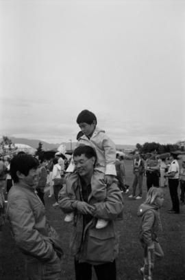
Paul Yee carrying Michael Yee on his shoulders at Charleson Park
Part of Paul Yee fonds
Item is a photograph showing Paul Yee carrying his nephew, Michael Yee, on his shoulders and talking to another unidentified man.