A visit to the north side of False Creek
- AM1519-: PAM 1974-62
- Item
- 1974
208 results with digital objects Show results with digital objects
A visit to the north side of False Creek

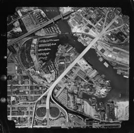
Aerial photo, vertical, False Creek, Fairview to Kits Point
Item is a photograph of False Creek, showing English Bay to W 16th Avenue, and from Maple Street to the Cambie Street Bridge. Includes the Burrard Street Bridge, the new Granville Bridge, the Cambie Bridge, and Granville Island.
Part of City of Vancouver fonds
Item is a photograph showing an aerial view from Oak Street to Pine Street, West 6th Avenue, and the north side of False Creek. Includes Granville Street Bridge, Granville Island and the Burrard Street Bridge.

Part of City of Vancouver fonds
Item is a photograph showing an aerial view from Spruce Street to Burrard Street, West 6th Avenue, and the north side of False Creek. Includes Granville Street Bridge, Granville Island and the Burrard Street Bridge.

Part of City of Vancouver fonds
Item is a photograph showing the east end of False Creek. From just west of Columbia Street to just east of Main Street, West 2nd Avenue to Keefer Street. Includes the Georgia Viaduct and Dunsmuir Viaduct.
![[Aerial view of lumber yard fire on south shore of False Creek]](/uploads/r/null/3/2/0/3208cbc9d06338a92738b56e1cb989d6c70179caf44b699eb76f28dadbba5a99/0c03d83a-377f-47eb-bbde-90519d0ddcea-CVA354-411_142.jpg)
[Aerial view of lumber yard fire on south shore of False Creek]
Part of City of Vancouver fonds
Item is a photograph showing a fire at Alberta Lumber Co. Ltd. at 790 West 6th Avenue.

Boathouse Shacktown, False Creek

Part of City of Vancouver fonds
Item is a photograph showing buildings and roadwork under construction.

Part of City of Vancouver fonds
Item is a photograph showing buildings and roadwork under construction.
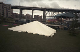
Canopy for stage on grass underneath Granville Street Bridge
![[Centennial employees building stage platform]](/uploads/r/null/e/2/4/e24865cfb50a51f74063f522f8f70003e5c5c395cb904467babb850ad89e138d/f1c48b90-9d15-444b-8d78-725f6499c81a-2011-010_142.jpg)
[Centennial employees building stage platform]
![[Centennial employees building stage platform]](/uploads/r/null/2/0/7/207da9d16e9f9cc0fa9566d1ec7336e508d3ab85459f06f16fd4e8ff2647068c/d337295e-8417-4f0b-9f35-4eaa7dc9ff30-2011-010_142.jpg)
[Centennial employees building stage platform]
![[Centennial employees building stage platform]](/uploads/r/null/d/b/8/db8a974e6ab3b47a78c9a9d3370841bc645544299421d036723d79cd442cd169/5489b780-6b38-4420-91e3-9349471d0c9f-2011-010_142.jpg)
[Centennial employees building stage platform]

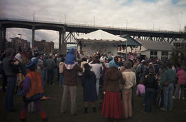
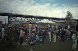
Centennial stage at Fool's Day Parade

Chevron stage at Fool's Day Parade
Chevron stage beside Isadora's underneath Granville Street Bridge
Part of Elizabeth Walker fonds
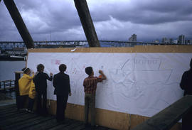
Item is a photograph showing children on False Creek tour drawing on paper. Written on slide: "filling in impressions of what future should be for area."

Children playing with goo at Fool's Day Parade

Children watching person blowing bubbles at Fool's Day Parade
Citizen's Council on Civic Development presents citizens forum : redevelopment of False Creek
Item announces a forum featuring Walter Hardwick, Alderman, City of Vancouver; Doug Sutcliffe, Development Consultant; Terrence Tanner, Architect; and Rick Elligott, Moderator.
City of Vancouver : Canadian Pacific town site
Part of City of Vancouver Archives technical and cartographic drawing collection
Primary map shows lot numbers and boundaries, streets, fire limits and "soundings in feet" (in English Bay, Burrard Inlet, Coal Harbour and False Creek) in downtown Vancouver, Stanley Park and parts of Kitsilano and Fairview. The ancillary maps show an "Index plan of Vancouver, B.C.", an "Index plan of [Vancouver] city limits" and "Canadian Pacific Mail Steamship Lines" (a map of Canadian Pacifc steamship routes around the world). On recto, the item also includes a description of Stanley Park and an illustration of Vancouver's inner harbour. On verso, the item includes descriptions of major Vancouver residences, imports, exports, businesses and other landmarks.

City of Vancouver, Canadian Pacific Town Site
Part of City of Vancouver Archives technical and cartographic drawing collection
The map shows the area currently occupied by Downtown Vancouver and parts of Kitsilano. It shows the location of C.P.R. Wharf, Royal City Saw Mills, Hastings Saw Mill and Wharf, Leamy and Kyle's Saw Mill and other saw mills. "Streets graded and side-walked marked thus . . . . .." An insert shows "Canadian Pacific Mail Steamship Lines" on a map of the world. The north shore of Burrard Inlet indicates the locations of "Indian Houses" and a mission church.
Part of City of Vancouver Archives technical and cartographic drawing collection
Item is a map showing the location of City-owned properties around the perimeter of the western half of False Creek, west of the Connaught Bridge (Cambie Street Bridge) as of Nov. 1969. City-owned lots are outlined in coloured pencil. Notations are also included on land usage, ownership and land transfers os some south shore properties not owned by the City.
Annotations have been made on a part of a copy of a base map originally created to show land transfers between the C.P.R and the Government of British Columbia.
Vancouver (B.C.). Properties Division

Clowns holding gelatin model on stage at Fool's Day Parade

Corinne Lee posing with a car at Granville Island
Part of Paul Yee fonds

Corinne Lee posing with a car at Granville Island
Part of Paul Yee fonds

Corinne Lee posing with a car at Granville Island
Part of Paul Yee fonds

Corinne Lee posing with a car at Granville Island
Part of Paul Yee fonds

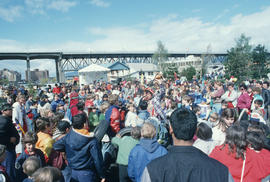
Crowd assembled around Chevron Stage during Fool's Day event
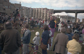
Crowd assembled around Chevron Stage during Fool's Day event
Crowd assembled around Chevron Stage during Fool's Day event

Crowd assembled at Fool's Day Parade
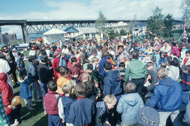

Crowd looking towards Centennial stage at Fool's Day Parade

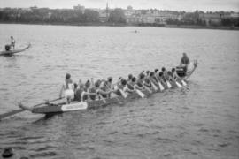
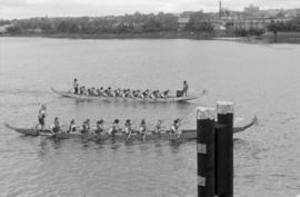
Dragon boat race on False Creek
Part of Paul Yee fonds

Dragon boat race on False Creek
Part of Paul Yee fonds

Dragon boat race on False Creek
Part of Paul Yee fonds
Dragon boat race on False Creek
Part of Paul Yee fonds
Dragon boat race on False Creek
Part of Paul Yee fonds

Dragon boat race on False Creek
Part of Paul Yee fonds
Dragon boat race on False Creek
Part of Paul Yee fonds
Dragon boat race on False Creek
Part of Paul Yee fonds

Dragon boat race spectators at Charleson Park
Part of Paul Yee fonds
Item is a photograph showing Romy So and Selina Chew.

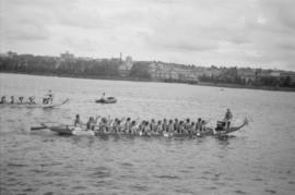
Dragon boat race spectators at the seawall on the south shore of False Creek
Part of Paul Yee fonds

Dragon boat race spectators at the seawall on the south shore of False Creek
Part of Paul Yee fonds

Dragon boat race spectators at the seawall on the south shore of False Creek
Part of Paul Yee fonds
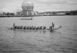
Item is a photograph showing Dragon boat race spectators at the seawall on the south shore of False Creek. Dragon boats and a portion of the Expo 86 fairgrounds are visible in the background of this photograph.

Dragon boat race spectators at the seawall on the south shore of False Creek
Part of Paul Yee fonds

Part of Paul Yee fonds