
Plan showing locations of oil and gas seepages and oil wells in Fraser Valley, British Columbia
Map and information concerning the City and District of New Westminster and the Province of British Columbia
Map and information concerning the City and District of New Westminster and the Province of British Columbia
Sectional map and street directory of Vancouver : Dial map of the city of Vancouver including adjacent municipalities
Sectional map and street directory of Vancouver : Dial map of the city of Vancouver including adjacent municipalities

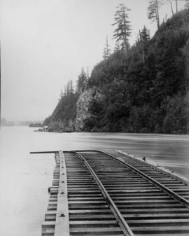
Profile Mile 27 to Mile 58 Port Mann Subdivision

Boy driving threshing machine on Fraser Valley farm
![[Dirt track auto race]](/uploads/r/null/e/0/e0452f50a8b1238d0675ba1a88c300b88983b065e8ff4ec86e8b81f006d75edd/384c1671-a0d9-4fe0-960e-cf9decfd30da-A16853_142.jpg)
[Dirt track auto race]
Greater Vancouver and Fraser Valley
Greater Vancouver and Fraser Valley

Greater Vancouver and Fraser Valley
Map of the Fraser Valley
Map of the Fraser Valley
Flooding over railroad tracks

Railroad tracks and parts tied down during flood

Washed out railroad tracks during flood
Sectional map and street directory of Vancouver : Dial map of the city of Vancouver including adjacent municipalities
Sectional map and street directory of Vancouver : Dial map of the city of Vancouver including adjacent municipalities
Road map of the Lower Fraser Valley, western portion
Road map of the Lower Fraser Valley, western portion
Sectional map and street directory of the Fraser Valley British Columbia
Sectional map and street directory of the Fraser Valley British Columbia
Road map of the Lower Fraser Valley, eastern portion
Road map of the Lower Fraser Valley, eastern portion
Map of Fraser Valley : from Langley to Harrison
Map of Fraser Valley : from Langley to Harrison
[Hatzic to Deroche]
[Hatzic to Deroche]
Roberts Bank rail route
Roberts Bank rail route
New Westminster Land District (Maple Ridge, B.C.)
New Westminster Land District (Maple Ridge, B.C.)
Soil map of Maple Ridge, Pitt Meadows Coquitlam area
Soil map of Maple Ridge, Pitt Meadows Coquitlam area
Soil map of municipality of Pitt Meadows, B.C.
Soil map of municipality of Pitt Meadows, B.C.
New Westminster District (Langley, B.C.)
New Westminster District (Langley, B.C.)
Subdivision and land use : residential analysis (Pitt Meadows, B.C.)
Subdivision and land use : residential analysis (Pitt Meadows, B.C.)
Garabaldi Park
Garabaldi Park
Surrey and surrounding areas
Surrey and surrounding areas
Natural gas transmission line Huntingdon to New Westminster proposed right of way
Natural gas transmission line Huntingdon to New Westminster proposed right of way
Subdivision and land use : commercial survey (Maple Ridge, B.C.)
Subdivision and land use : commercial survey (Maple Ridge, B.C.)
Subdivision and land use : residential analysis (Fraser Valley)
Subdivision and land use : residential analysis (Fraser Valley)
Subdivision and land use : industrial survey (Mission, B.C.)
Subdivision and land use : industrial survey (Mission, B.C.)
Residential analysis - Matsqui - Abbotsford
Residential analysis - Matsqui - Abbotsford
Chilliwack Lake, B.C.
Chilliwack Lake, B.C.
Surficial geology (Chilliwack, B.C.)
Surficial geology (Chilliwack, B.C.)
Soil capability map of Chilliwack
Soil capability map of Chilliwack
Subdivision and land use : industrial survey (Fraser Valley, B.C.)
Subdivision and land use : industrial survey (Fraser Valley, B.C.)
Laidlaw - Hope transmission line right of way
Laidlaw - Hope transmission line right of way
Subdivision and land use : industrial survey (Fraser Valley, B.C.)
Subdivision and land use : industrial survey (Fraser Valley, B.C.)
Fraser Valley Region, B.C.
Fraser Valley Region, B.C.

Map of Fraser Valley

Map of Fraser Valley, British Columbia
Street map of the Fraser Valley

Map of Fraser Valley
Sectional map and street directory of Vancouver : Dial map of the city of Vancouver including adjacent municipalities
Sectional map and street directory of Vancouver : Dial map of the city of Vancouver including adjacent municipalities
Sectional map and street directory of Vancouver : Dial map of the city of Vancouver including adjacent municipalities
Sectional map and street directory of Vancouver : Dial map of the city of Vancouver including adjacent municipalities
Sectional map and street directory of Vancouver : Dial map of the city of Vancouver including adjacent municipalities
Sectional map and street directory of Vancouver : Dial map of the city of Vancouver including adjacent municipalities
Road map of the Lower Fraser Valley, eastern portion
Road map of the Lower Fraser Valley, eastern portion
Road map of the Lower Fraser Valley, western portion
Road map of the Lower Fraser Valley, western portion
Road map of the Lower Fraser Valley, eastern portion [left half]
Road map of the Lower Fraser Valley, eastern portion [left half]
[Langley to Matsqui]
[Langley to Matsqui]
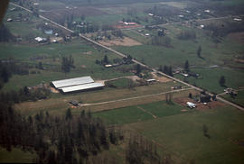
Geographical : Aerial Fraser Valley