- AM753-S1-F2-: CVA 256-02.13
- Item
- [ca. 1894]
Part of Elizabeth Abbott fonds
18 results with digital objects Show results with digital objects
Part of Elizabeth Abbott fonds

Part of Elizabeth Abbott fonds
Part of Elizabeth Abbott fonds
Part of Elizabeth Abbott fonds
Greater Vancouver and Fraser Valley
Part of City of Vancouver Archives technical and cartographic drawing collection
Item is a pamphlet containing a map of Greater Vancouver and the Fraser Valley on one side and text promoting British Columbia and the services of Western Development and Power Limited on the other. Map shows the B.C. Electric railway line within the Greater Vancouver and Fraser Valley area, other railway lines, main roads, municipal boundaries, industrial sites, airports and ports. An inset map shows the total area served by B.C. Electric within British Columbia and the location of Greater Vancouver and the Fraser Valley within that area.

Greater Vancouver and Fraser Valley
Part of City of Vancouver Archives technical and cartographic drawing collection
Part contains a map showing the B.C. Electric railway line within the Greater Vancouver and Fraser Valley area, other railway lines, main roads, municipal boundaries, industrial sites, airports and ports. An inset map shows the total area served by B.C. Electric within British Columbia and the location of Greater Vancouver and the Fraser Valley within that area.

Man in rowboat on floodwaters at washed out railroad tracks
Part of Elizabeth Abbott fonds

Item is a map of the Fraser Valley from Vancouver to Chilliwack showing roads, railway lines, schools, churches, and post offices.

Map of Fraser Valley, British Columbia
Item is a map showing trunk roads, main and local roads, and railway lines.
Map of railway freight lines operated by British Columbia Hydro and Power Authority
Part of City of Vancouver Archives technical and cartographic drawing collection
Item is a map showing the B.C. Electric railway (including the Vancouver and Lulu Island branch), other railways, interchange points and municipal city boundaries. Map is designed to be folded in two; cover on verso.
Map of the Fraser Valley showing railway lines and district lots
Part of City of Vancouver Archives technical and cartographic drawing collection
Item contains a map of the Fraser Valley showing railway lines and district lots on one side and text advertising the British Columbia Electric Railway Company's interurban lines on the other.

Map of the Fraser Valley showing railway lines and district lots
Part of City of Vancouver Archives technical and cartographic drawing collection

Map of the municipalities of New Westminster City and District, British Columbia
Part of City of Vancouver Archives technical and cartographic drawing collection
Part contains a map of the Lower Mainland and Fraser Valley from the Gulf of Georgia in the west to Harrison Lake in the east. Map shows locations of churches, schools, canneries, sawmills, brickyards, tanneries, woolen mills and hatcheries; existing and proposed railways; and roadways.

Men in boat on floodwaters at washed out railroad tracks
Part of Elizabeth Abbott fonds

Profile Mile 27 to Mile 58 Port Mann Subdivision
Part of City of Vancouver fonds
Item is a profile of the Canadian Northern Railway right of way through the Fraser Valley.

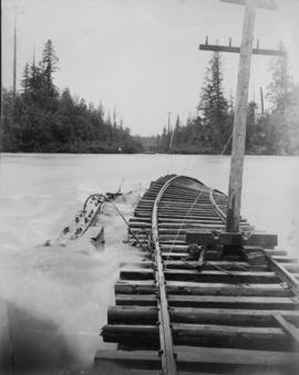
Railroad tracks and parts tied down during flood
Part of Elizabeth Abbott fonds

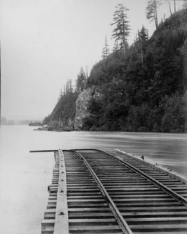
View of railroad tracks during flood
Part of Elizabeth Abbott fonds

Part of Elizabeth Abbott fonds

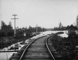
Washed out railroad tracks during flood
Part of Elizabeth Abbott fonds

Washed out railroad tracks during flood
Part of Elizabeth Abbott fonds

Washed out railroad tracks during flood
Part of Elizabeth Abbott fonds