Townsite tales: the history of Ioco, Anmore Valley, and north shore of Port Moody Arm
Townsite tales: the history of Ioco, Anmore Valley, and north shore of Port Moody Arm
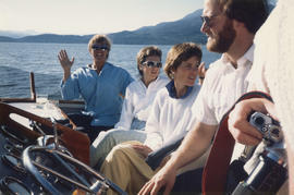
Group on boat cruise in the Burrard Inlet

Group on boat cruise with Lion's Gate Bridge in background

Interior of boat

Boat in the Burrard Inlet

Group indoors on boat cruise

Randie Smith on boat cruise with Canada Place in background

Group on boat cruise in the Burrard Inlet

Group indoors on boat cruise

Group indoors on boat cruise

Group on boat cruise

Group on boat cruise in the Burrard Inlet

Group on boat cruise in the Burrard Inlet
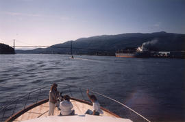
Group on boat cruise with Lion's Gate Bridge in background

View of Canada Place from boat cruise

Group seated at indoor table on boat cruise

Fishing boats in Burrard Inlet coming in with their catch
Airstrip at Brockton Point (day flyings)
Airstrip at Brockton Point (day flyings)
![Second Narrows [on] harbour tour](/uploads/r/null/b/2/e/b2ea67536bdb443ce9ad21b9ce328068de0d7aa9252a7ea17ab7aeb9cec67c8f/78042a33-bebb-41f2-ac8e-edfa5de1b752-CVA289-266_142.jpg)
Second Narrows [on] harbour tour

Harbour tour supper

Harbour tour

Harbour tour

Vancouver Harbour. British Columbia

Second Narrows crossing
Tidal current charts : Vancouver Harbour, British Columbia
Tidal current charts : Vancouver Harbour, British Columbia
Vancouver Harbour : plan of south shore, Burrard Inlet between Heatley Ave. and Victoria Dr.
Vancouver Harbour : plan of south shore, Burrard Inlet between Heatley Ave. and Victoria Dr.

Vancouver Harbour : Sheet 1 (First Narrows to Second Narrows)

Vancouver Harbour : Sheet 2 (Point Grey to Second Narrows)

Vancouver Harbour : Sheet 3 (Second Narrows to Port Moody)

Vancouver North. British Columbia
Plan of North Arm - Burrard Inlet
Plan of North Arm - Burrard Inlet

Indian villages and landmarks, Burrard Inlet and Howe Sound before the whitemans came

Sko-Mish-Oath : the territory of the Squamish Indian People : Indian villages and landmarks : Burrard Inlet and Howe Sound before the whitemans came

Port of the City of Vancouver. Isometric view from the south-west

Belcarra jetty
Plan showing proposed location of pressure tunnel, shafts, and connecting pipe lines at First Narrows, Burrard Inlet, Vancouver, B.C.
Plan showing proposed location of pressure tunnel, shafts, and connecting pipe lines at First Narrows, Burrard Inlet, Vancouver, B.C.

18,000 ton floating drydock at Burrard Drydock Company yards : January 1931
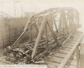
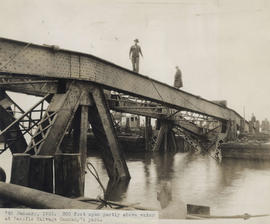
300 foot span on drydock : January 11, 1931

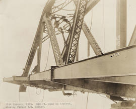
300 foot span on drydock, showing former north half of west side : January 11, 1931
300 foot span on drydock, showing former north west corner : January 11, 1931

300 foot span on drydock, showing former north east corner : January 11, 1931
300 foot span on drydock, showing former south west corner : January 11, 1931

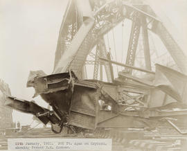
Detail of 300 foot span partly above water at Pacific Salvage Company's yard : January 7, 1931
300 foot span partly above water at Pacific Salvage Company's yard : January 7, 1931

Detail of 300 foot span partly above water at Pacific Salvage Company's yard : January 7, 1931

Aerial of Second Narrows bridge and the Alberta Pool Elevator Company

Detail of damage to bascule span by the hulk Pacific Gatherer : April 19, 1930

Detail of damage done to the rail and pedestrian walkway by the hulk Pacific Gatherer : April 19, 1930
Image of missing 300 foot span : September 19, 1930

Detail of damage done by the hulk Pacific Gatherer : April 19, 1930