
- AM1535-: CVA 99-2635
- Item
- [ca. 1932]
Part of Stuart Thomson fonds
Part of Stuart Thomson fonds
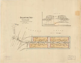
Ballantyne Pier, Burrard Inlet, Vancouver, B.C.
Part of City of Vancouver Archives technical and cartographic drawing collection
Item is a fire insurance plan of Ballantyne Pier, showing structural and fire fighting information for the purposes of determining fire rating for the site The sheet also includes an architectural section of the outer and inner berth buildings.
British Columbia Underwriters' Association

Port of the City of Vancouver. Isometric view from the south-west
Part of City of Vancouver Archives technical and cartographic drawing collection
Item is a set of maps printed on one sheet. The main map shows an isometric view of the port of Vancouver from Stanley Park through the Second Narrows Bridge (including North Vancouver). The perspective point appears to be located above the Granviile Street and West Georgia Street intersection. Note that the isometric view of locations west of Granville Street is from the south-east, rather than the south-west, as indicated in the title.
The map depicts the port infrastructure, including piers, drydocks and companies located in the port.
The inset maps are a key plan showing the location of the port relative to the Lower Mainland as a whole, and a larger-scale map entitled "Plan of the Port of the City of Vancouver from Coal Harbour to Second Narrows". It contains more detail about the names of the various piers, drydocks and companies and shows the North Vancouver port facilities as well as south shore ones.