Showing 361 results

Archival description
Burrard Inlet (B.C.) Item With digital objects
Print preview View:

Burrard Inlet sheet II

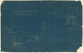
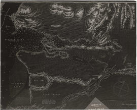
Item is a copy of a portion of a manuscript map of Burrard Inlet, created during the H.M.S. Plumper survey of the area. Sheet shows the eastern portion of the Inlet, including the southern portion of the North Arm.

United Kingdom. Admiralty

City of Vancouver, Canadian Pacific Town Site

The map shows the area currently occupied by Downtown Vancouver and parts of Kitsilano. It shows the location of C.P.R. Wharf, Royal City Saw Mills, Hastings Saw Mill and Wharf, Leamy and Kyle's Saw Mill and other saw mills. "Streets graded and side-walked marked thus . . . . .." An insert shows "Canadian Pacific Mail Steamship Lines" on a map of the world. The north shore of Burrard Inlet indicates the locations of "Indian Houses" and a mission church.

Plan of proposed dam, locks and wharves. Second Narrows, Burrard Inlet

Item consists of a design for a proposed dam and locks system to be located near the Second Narrows of Burrard Inlet. One side of the dammed area is marked "reclaimed tideflats available for industrial purposes," the other "land available for industrial or other purposes." Sites for warehouses are indicated on the dam.

Kilmer and Holland, Engineers and Surveyors

The "First Narrows" entrance to Vancouver Harbor.

Item is a postcard printed with an image of a passenger ferry entering the First Narrows. The Prospect Point lighthouse and a smaller building with a ramp leading down to the water are shown; the area of the North Shore across the First Narrows is also pictured. Postcard includes personal correspondence. Sent to Mrs. Shand in Edmonds, B.C., from F. Pullen in Vancouver.

Burrard Inlet : Vancouver sheet : British Columbia

Item is a map showing streets, roads, buildings, trails, railways, electric railways, bridges, swing bridges, foot bridges, churches, schools, post offices, wharves, piers, dikes, piling lighthouses, lightships, beacons, ranges, range lights, buoys, triangulation stations and geographical features in Burrard Inlet from Moodyville in the east to First Narrows in the west. A small index map shows this and other numbered sheets in relation to one another.

Results 1 to 50 of 361