
Burrard Inlet - Vancouver sheet
- AM1594-MAP 1157-: LEG1153.055
- Item
- 1921
Part of City of Vancouver Archives technical and cartographic drawing collection
30 results with digital objects Show results with digital objects
Burrard Inlet - Vancouver sheet
Part of City of Vancouver Archives technical and cartographic drawing collection

Burrard Inlet - Second Narrows sheet
Part of City of Vancouver Archives technical and cartographic drawing collection

Burrard Inlet - Dollarton sheet
Part of City of Vancouver Archives technical and cartographic drawing collection

Part of City of Vancouver Archives technical and cartographic drawing collection

Burrard Inlet - Port Moody sheet
Part of City of Vancouver Archives technical and cartographic drawing collection

Burrard Inlet - triangulation control
Part of City of Vancouver Archives technical and cartographic drawing collection

Sketch of proposed interurban canal and harbour development for Greater Vancouver, B.C.
Part of City of Vancouver Archives technical and cartographic drawing collection
Item is a copy of a map depicting the approximate location of a proposed canal from Burrard Inlet to the Pitt River and the Canadian Pacific Railway line. The map also includes "Detail of wharves and locks at Second Narrows".
Coquitlam (B.C.). Engineer's Office
City of Vancouver : Canadian Pacific town site
Part of City of Vancouver Archives technical and cartographic drawing collection
Primary map shows lot numbers and boundaries, streets, fire limits and "soundings in feet" (in English Bay, Burrard Inlet, Coal Harbour and False Creek) in downtown Vancouver, Stanley Park and parts of Kitsilano and Fairview. The ancillary maps show an "Index plan of Vancouver, B.C.", an "Index plan of [Vancouver] city limits" and "Canadian Pacific Mail Steamship Lines" (a map of Canadian Pacifc steamship routes around the world). On recto, the item also includes a description of Stanley Park and an illustration of Vancouver's inner harbour. On verso, the item includes descriptions of major Vancouver residences, imports, exports, businesses and other landmarks.

Part of City of Vancouver Archives technical and cartographic drawing collection
Item is a map showing major landmarks, railway lines, harbour lands reclaimed, proposed wharves and piers, retaining walls and dredging, and soundings in fathoms in Vancouver Harbour (Burrard Inlet) and False Creek.
Tidal current charts : Vancouver Harbour, British Columbia
Part of City of Vancouver Archives technical and cartographic drawing collection
Item is a booklet containing twelve charts showing tidal currents in Vancouver Harbour at different points in the tidal cycle.
Fraser River and Burrard Inlet
Part of City of Vancouver Archives technical and cartographic drawing collection
Item is a nautical chart which show details of the area surveyed from Pitt Lake in the north to Roberts Bank in the south and from (what is now) Harrison Hot Springs in the east to Bowen Island in the west. The chart shows soundings in Burrard Inlet, and along the Fraser River.
Second Narrows Dam : general plan
Part of City of Vancouver Archives technical and cartographic drawing collection
First map shows the "proposed V.H.C. terminal railway" route along the southern shore of False Creek, along the southern shore of Burrard Inlet, across Second Narrows and along the northern shore of Burrard Inlet in North Vancouver. The second map shows details of the proposed dam and locks at Second Narrows. The additional sheet outlines the estimated costs of the proposed dam and locks at Second Narrows.
Cross sections of channel and proposed dam, Second Narrows Dam
Part of City of Vancouver Archives technical and cartographic drawing collection
Map contains two depictions: cross section showing proposed dam and locks and cross section of the dam. Sheet 2 of 3.

Plan of proposed dam, locks and wharves. Second Narrows, Burrard Inlet
Part of City of Vancouver Archives technical and cartographic drawing collection
Item consists of a design for a proposed dam and locks system to be located near the Second Narrows of Burrard Inlet. One side of the dammed area is marked "reclaimed tideflats available for industrial purposes," the other "land available for industrial or other purposes." Sites for warehouses are indicated on the dam.
Kilmer and Holland, Engineers and Surveyors

Vancouver North. British Columbia
Part of City of Vancouver Archives technical and cartographic drawing collection
Item is a topographical map showing the eastern portion of Sechelt Peninsula, Keats Island, southern portion of Gambier Island, Bowen Island, West Vancouver, North Vancouver, and Vancouver. City streets and blocks are shown, as well as surveyed parcels of land. Map also shows depth contours in fathoms for Howe Sound and Burrard Inlet.
Part of City of Vancouver Archives technical and cartographic drawing collection
Item is an architectural drawing depicting existing and proposed water mains crossing the First Narrows.The drawing includes a plan, sections and details, as well as a key plan of the site location.
Greater Vancouver Water District
Part of City of Vancouver Archives technical and cartographic drawing collection
Item is a topographic map in two sections showing British Columbia north of Burrard Inlet to Britannia Creek in the north, and from Howe Sound in the west to Indian Arm in the east. Map shows lakes, streams and other natural features; roads, railways, communication lines, cities and other built features; and land, timber, and mineral surveys by number.
![Howe Sound - Burrard Inlet [Burrard Inlet portion]](/uploads/r/null/f/8/5/f8523992bb5d5e0c1391f2dea183041a54a2d2470eb4047bb29958a0d835ae95/fdf9563d-923e-468a-a494-3ff190294b91-MAP30b_142.jpg)
Howe Sound - Burrard Inlet [Burrard Inlet portion]
Part of City of Vancouver Archives technical and cartographic drawing collection
Part shows the Lower Mainland and Burrard Inlet from Howe Sound in the west to Indian Arm in the east. Map shows topographic contour lines, elevations, lakes, streams and other natural features, roads, railways, communication lines, cities and other settlements, and land, timber, and mineral surveys by number. Includes a list of sources of information.

City of Vancouver, Canadian Pacific Town Site
Part of City of Vancouver Archives technical and cartographic drawing collection
The map shows the area currently occupied by Downtown Vancouver and parts of Kitsilano. It shows the location of C.P.R. Wharf, Royal City Saw Mills, Hastings Saw Mill and Wharf, Leamy and Kyle's Saw Mill and other saw mills. "Streets graded and side-walked marked thus . . . . .." An insert shows "Canadian Pacific Mail Steamship Lines" on a map of the world. The north shore of Burrard Inlet indicates the locations of "Indian Houses" and a mission church.

Tourist guide map of Vancouver City and Park
Part of City of Vancouver Archives technical and cartographic drawing collection
The map shows the area currenlty occupied by Downtown Vancouver and parts of Kitsilano. It shows the location of C.P.R. Wharves, Hastings Saw Mill and other saw and shingle mills. "Note, Electric street railway shewn in Red."
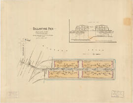
Ballantyne Pier, Burrard Inlet, Vancouver, B.C.
Part of City of Vancouver Archives technical and cartographic drawing collection
Item is a fire insurance plan of Ballantyne Pier, showing structural and fire fighting information for the purposes of determining fire rating for the site The sheet also includes an architectural section of the outer and inner berth buildings.
British Columbia Underwriters' Association

Vancouver Harbour : Sheet 1 (First Narrows to Second Narrows)
Part of City of Vancouver Archives technical and cartographic drawing collection
Item is a nautical chart of Vancouver Harbour from First Narrows in the west to Second Narrows in the east, showing soundings in fathoms, tidal information, anchorages, beacons, and waterfront businesses. Street names are shown on land areas.

Vancouver Harbour : Sheet 2 (Point Grey to Second Narrows)
Part of City of Vancouver Archives technical and cartographic drawing collection
item is a nautical chart of Burrard Inlet and Vancouver Harbour from Point Grey in the west to Second Narrows in the east, showing soundings in fathoms, tidal information, anchorages, beacons, and waterfront businesses. Street names are shown on land areas. A Royal Canadian Air Force bombing range at Jericho Beach is identified as a danger area.

Vancouver Harbour : Sheet 3 (Second Narrows to Port Moody)
Part of City of Vancouver Archives technical and cartographic drawing collection
Item is a nautical chart of Vancouver Harbour from Second Narrows in the west to Port Moody in the east, showing soundings in fathoms, tidal information, anchorages, beacons, and waterfront businesses. Street names are shown on land areas.

Vancouver Harbour. British Columbia
Part of City of Vancouver Archives technical and cartographic drawing collection
Item is a map sheet containing three nautical charts. The main map shows English Bay and Burrard Inlet and the land bordering these bodies of water, including North and West Vancouver, Downtown Vancouver, the University Endowment Lands and Port Moody. Inset maps depict the north arm of Burrard Inlet and a chart showing Vancouver Island in relation to the B.C. coast and the state of Washington, U.S.A.

North America. West Coast. Fraser River and Burrard Inlet
Part of City of Vancouver Archives technical and cartographic drawing collection
Item is a nautical chart which show details of area surveyed from Pitt Lake in the north to Roberts Bank in the south and from (what is now) Harrison Hot Springs in the east to Bowen Island in the west. The chart shows soundings in Burrard Inlet, and along the Fraser River.

Part of City of Vancouver Archives technical and cartographic drawing collection
Item is a sheet with three nautical charts. The main chart depicts Burrard Inlet from Atkinson Point [Point Atkinson] in the west to the "townsite of Port Moody" in the east. The inset charts depict Vancouver Harbour and the Second Narrows.

First Narrows, Burrard Inlet, B.C. showing Parthia and Burnaby shoals
Part of City of Vancouver Archives technical and cartographic drawing collection
Item is a map showing shorelines, estuaries of adjacent creeks, mud flats, tide levels and soundings in feet. Map notes velocity of current at First Narrows.
New Westminster (B.C.). Department of Public Works

North America. West Coast. Fraser River and Burrard Inlet
Part of City of Vancouver Archives technical and cartographic drawing collection
Item is a nautical chart which show details of area surveyed from Pitt Lake in the north to Roberts Bank in the south and from (what is now) Harrison Hot Springs in the east to Bowen Island in the west. The chart shows soundings in Burrard Inlet, and along the Fraser River.

Part of City of Vancouver Archives technical and cartographic drawing collection
Item is an architectural drawing of a Second Narrows crossing, bridging Vancouver and North Vancouver. The drawing consists of an elevation of the bridge, as well as a plan of the bridge and the north and south approaches.
Part of City of Vancouver Archives technical and cartographic drawing collection
Item is a nautical chart depicting Burrard Inlet, including English Bay, Vancouver Harbour, False Creek, Second Narrows, the North Arm of Burrard Inlet and Port Moody. Soudings are given in fathoms.
![Granville [Townsite], B.C. Aug., 1885](/uploads/r/null/1/a/4/1a45ddd637fe3f3726748d5096017a8461446b9a013c408ed2b1666c8433e1f9/405fdc0d-6d88-41b7-937f-36cc7f51518a-MAP553_142.jpg)
Granville [Townsite], B.C. Aug., 1885
Part of City of Vancouver Archives technical and cartographic drawing collection
Item is a fire insurance map of the "Coal Harbour" [south shore of Burrard Inlet] area. The Hastings Saw Mill Company and Coal Harbour Fishery are shown in detail. Other businesses along Front Street are identified including hotels and stores.
Vancouver Harbour : plan of south shore, Burrard Inlet between Heatley Ave. and Victoria Dr.
Part of City of Vancouver Archives technical and cartographic drawing collection
Item is a map which shows parcels of land along Burrard Inlet and district lots in downtown Vancouver. Piers, factories and mills along the waterfront are identified. Soundings are shown in feet.
National Harbours Board

North America - West Coast. British Columbia. Burrard Inlet
Part of City of Vancouver Archives technical and cartographic drawing collection
Item is a map sheet containing four nautical charts and one illustration. The main chart depicts Burrard Inlet; the three inset charts depict First Narrows, Vancouver Harbour and Second Narrows. The charts depict soundings and physical features. The illustration is of Point Atkinson Lighthouse.

Part of City of Vancouver Archives technical and cartographic drawing collection
Item is a photostat copy of a portion of a map of Burrard Inlet from the 1859 H.M.S. Plumper Survey. The map depicts outer Burrard Inlet and the surrounding shorlines.

Part of City of Vancouver Archives technical and cartographic drawing collection
Item is a copy of a portion of a British Admiralty hydrographic survey of Burrard Inlet. The copied portion shows the area from First Narrows to just east of Capital Hill. The map shows soundings in the Inlet, as well as indications of topography of the surrounding shoreline areas.

Port of the City of Vancouver. Isometric view from the south-west
Part of City of Vancouver Archives technical and cartographic drawing collection
Item is a set of maps printed on one sheet. The main map shows an isometric view of the port of Vancouver from Stanley Park through the Second Narrows Bridge (including North Vancouver). The perspective point appears to be located above the Granviile Street and West Georgia Street intersection. Note that the isometric view of locations west of Granville Street is from the south-east, rather than the south-west, as indicated in the title.
The map depicts the port infrastructure, including piers, drydocks and companies located in the port.
The inset maps are a key plan showing the location of the port relative to the Lower Mainland as a whole, and a larger-scale map entitled "Plan of the Port of the City of Vancouver from Coal Harbour to Second Narrows". It contains more detail about the names of the various piers, drydocks and companies and shows the North Vancouver port facilities as well as south shore ones.

Plan of the Burrard Inlet and Pitt River canal location
Part of City of Vancouver Archives technical and cartographic drawing collection
Item is a map which depicts the route of a proposed canal running from Port Moody to the Pitt River through the Coquitlam River. Lot numbers and the Canadian Pacific railway line are also shown.

Burrard Inlet : Vancouver sheet : British Columbia
Part of City of Vancouver Archives technical and cartographic drawing collection
Item is a map showing streets, roads, buildings, trails, railways, electric railways, bridges, swing bridges, foot bridges, churches, schools, post offices, wharves, piers, dikes, piling lighthouses, lightships, beacons, ranges, range lights, buoys, triangulation stations and geographical features in Burrard Inlet from Moodyville in the east to First Narrows in the west. A small index map shows this and other numbered sheets in relation to one another.
Fraser River and Burrard Inlet
Part of City of Vancouver Archives technical and cartographic drawing collection
Vancouver Harbour, British Columbia
Part of City of Vancouver Archives technical and cartographic drawing collection
Item is a nautical chart of Burrard Inlet, including the southern portions of the North Arm of Burrard Inlet. The map shows depth soundings, harbour anchorages, headlines, beacons, buoys, bells, piers and wharves. The map also shows lot numbers, municipal boundaries and major street names of the southern portion of North Vancouver and the northern portions of Point Grey, Kitsilano, Mt. Pleasant, Fairview, Hastings Townsite, Burnaby and Port Moody from the Coquitlam municipal boundary in the east to the western boundary of the Vancouver harbour (between Point Atkinson and Point Grey) in the west. The item also includes a key map showing the location of the Vancouver Harbour in relation to northwestern Washington and Vancouver Island and an inset map showing lots surrounding the north arm of Burrard Inlet to the Inlailawatash Indian Reserve.