
Shell Oil Co. - tanks at Barnet
- AM1535-: CVA 99-192
- Item
- 1917
Part of Stuart Thomson fonds
Shell Oil Co. - tanks at Barnet
Part of Stuart Thomson fonds

Shell Oil Co. - tanks at Barnet
Part of Stuart Thomson fonds

Burrard Inlet - Vancouver sheet
Part of City of Vancouver Archives technical and cartographic drawing collection

Burrard Inlet - Dollarton sheet
Part of City of Vancouver Archives technical and cartographic drawing collection

Burrard Inlet - Second Narrows sheet
Part of City of Vancouver Archives technical and cartographic drawing collection

Part of City of Vancouver Archives technical and cartographic drawing collection

Burrard Inlet - Port Moody sheet
Part of City of Vancouver Archives technical and cartographic drawing collection

Burrard Inlet - triangulation control
Part of City of Vancouver Archives technical and cartographic drawing collection

Part of City of Vancouver Archives technical and cartographic drawing collection
Item is a map showing major landmarks, railway lines, harbour lands reclaimed, proposed wharves and piers, retaining walls and dredging, and soundings in fathoms in Vancouver Harbour (Burrard Inlet) and False Creek.

Vancouver Harbour. British Columbia
Part of City of Vancouver Archives technical and cartographic drawing collection
Item is a map sheet containing three nautical charts. The main map shows English Bay and Burrard Inlet and the land bordering these bodies of water, including North and West Vancouver, Downtown Vancouver, the University Endowment Lands and Port Moody. Inset maps depict the north arm of Burrard Inlet and a chart showing Vancouver Island in relation to the B.C. coast and the state of Washington, U.S.A.

North America. West Coast. Fraser River and Burrard Inlet
Part of City of Vancouver Archives technical and cartographic drawing collection
Item is a nautical chart which show details of area surveyed from Pitt Lake in the north to Roberts Bank in the south and from (what is now) Harrison Hot Springs in the east to Bowen Island in the west. The chart shows soundings in Burrard Inlet, and along the Fraser River.

North America - West Coast. British Columbia. Burrard Inlet
Part of City of Vancouver Archives technical and cartographic drawing collection
Item is a map sheet containing four nautical charts and one illustration. The main chart depicts Burrard Inlet; the three inset charts depict First Narrows, Vancouver Harbour and Second Narrows. The charts depict soundings and physical features. The illustration is of Point Atkinson Lighthouse.
Group on boat cruise in the Burrard Inlet

Group on boat cruise with Lion's Gate Bridge in background

Group on boat cruise in the Burrard Inlet

Group on boat cruise in the Burrard Inlet
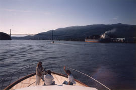
Group on boat cruise with Lion's Gate Bridge in background

View of Canada Place from boat cruise


Group on boat cruise in the Burrard Inlet
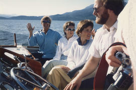
Item is a photograph showing Michael Francis (centre) and group on a boat cruise in the Burrard Inlet.


Group seated at indoor table on boat cruise


Tourist guide map of Vancouver City and Park
Part of City of Vancouver Archives technical and cartographic drawing collection
The map shows the area currenlty occupied by Downtown Vancouver and parts of Kitsilano. It shows the location of C.P.R. Wharves, Hastings Saw Mill and other saw and shingle mills. "Note, Electric street railway shewn in Red."

Business section & Burrard Inlet
Item is a photograph of downtown Vancouver, Granville Street, the waterfront, Burrard Inlet, and the north shore mountains, taken from an upper floor of the Birks Building (700 Granville Street), looking northwest.

Evening, Prospect Point, Stanley Park

Part of City of Vancouver Archives technical and cartographic drawing collection
Item is a sheet with three nautical charts. The main chart depicts Burrard Inlet from Atkinson Point [Point Atkinson] in the west to the "townsite of Port Moody" in the east. The inset charts depict Vancouver Harbour and the Second Narrows.

Sketch of proposed interurban canal and harbour development for Greater Vancouver, B.C.
Part of City of Vancouver Archives technical and cartographic drawing collection
Item is a copy of a map depicting the approximate location of a proposed canal from Burrard Inlet to the Pitt River and the Canadian Pacific Railway line. The map also includes "Detail of wharves and locks at Second Narrows".
Coquitlam (B.C.). Engineer's Office

Plan of proposed dam, locks and wharves. Second Narrows, Burrard Inlet
Part of City of Vancouver Archives technical and cartographic drawing collection
Item consists of a design for a proposed dam and locks system to be located near the Second Narrows of Burrard Inlet. One side of the dammed area is marked "reclaimed tideflats available for industrial purposes," the other "land available for industrial or other purposes." Sites for warehouses are indicated on the dam.
Kilmer and Holland, Engineers and Surveyors

Plan of the Burrard Inlet and Pitt River canal location
Part of City of Vancouver Archives technical and cartographic drawing collection
Item is a map which depicts the route of a proposed canal running from Port Moody to the Pitt River through the Coquitlam River. Lot numbers and the Canadian Pacific railway line are also shown.

"Burrard Inlet Dock" looking west from Campbell Ave. July 1, 1913

Fishing boats in Burrard Inlet coming in with their catch
Part of Vancouver Express fonds
Item is a photograph of fishing boats in Burrard Inlet, West Vancouver Sentinel Hill in background.

Indian villages and landmarks, Burrard Inlet and Howe Sound before the whitemans came
Part of Major Matthews collection
Item is a manuscript map showing the territory of the Squamish peoples using Squamish geographic names, as told to him by August Jack Khatsahlano.
Matthews, James Skitt, Major

Part of City of Vancouver Archives technical and cartographic drawing collection
Item is a photostat copy of a portion of a map of Burrard Inlet from the 1859 H.M.S. Plumper Survey. The map depicts outer Burrard Inlet and the surrounding shorlines.

Part of City of Vancouver Archives technical and cartographic drawing collection
Item is a copy of a portion of a British Admiralty hydrographic survey of Burrard Inlet. The copied portion shows the area from First Narrows to just east of Capital Hill. The map shows soundings in the Inlet, as well as indications of topography of the surrounding shoreline areas.

Vancouver Harbour : Sheet 3 (Second Narrows to Port Moody)
Part of City of Vancouver Archives technical and cartographic drawing collection
Item is a nautical chart of Vancouver Harbour from Second Narrows in the west to Port Moody in the east, showing soundings in fathoms, tidal information, anchorages, beacons, and waterfront businesses. Street names are shown on land areas.

Vancouver Harbour : Sheet 1 (First Narrows to Second Narrows)
Part of City of Vancouver Archives technical and cartographic drawing collection
Item is a nautical chart of Vancouver Harbour from First Narrows in the west to Second Narrows in the east, showing soundings in fathoms, tidal information, anchorages, beacons, and waterfront businesses. Street names are shown on land areas.

Vancouver Harbour : Sheet 2 (Point Grey to Second Narrows)
Part of City of Vancouver Archives technical and cartographic drawing collection
item is a nautical chart of Burrard Inlet and Vancouver Harbour from Point Grey in the west to Second Narrows in the east, showing soundings in fathoms, tidal information, anchorages, beacons, and waterfront businesses. Street names are shown on land areas. A Royal Canadian Air Force bombing range at Jericho Beach is identified as a danger area.

Vancouver North. British Columbia
Part of City of Vancouver Archives technical and cartographic drawing collection
Item is a topographical map showing the eastern portion of Sechelt Peninsula, Keats Island, southern portion of Gambier Island, Bowen Island, West Vancouver, North Vancouver, and Vancouver. City streets and blocks are shown, as well as surveyed parcels of land. Map also shows depth contours in fathoms for Howe Sound and Burrard Inlet.

Part of Stuart Thomson fonds
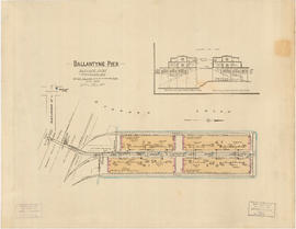
Ballantyne Pier, Burrard Inlet, Vancouver, B.C.
Part of City of Vancouver Archives technical and cartographic drawing collection
Item is a fire insurance plan of Ballantyne Pier, showing structural and fire fighting information for the purposes of determining fire rating for the site The sheet also includes an architectural section of the outer and inner berth buildings.
British Columbia Underwriters' Association
![Granville [Townsite], B.C. Aug., 1885](/uploads/r/null/1/a/4/1a45ddd637fe3f3726748d5096017a8461446b9a013c408ed2b1666c8433e1f9/405fdc0d-6d88-41b7-937f-36cc7f51518a-MAP553_142.jpg)
Granville [Townsite], B.C. Aug., 1885
Part of City of Vancouver Archives technical and cartographic drawing collection
Item is a fire insurance map of the "Coal Harbour" [south shore of Burrard Inlet] area. The Hastings Saw Mill Company and Coal Harbour Fishery are shown in detail. Other businesses along Front Street are identified including hotels and stores.

Part of William Orson Banfield fonds
![Second Narrows [on] harbour tour](/uploads/r/null/b/2/e/b2ea67536bdb443ce9ad21b9ce328068de0d7aa9252a7ea17ab7aeb9cec67c8f/78042a33-bebb-41f2-ac8e-edfa5de1b752-CVA289-266_142.jpg)
Second Narrows [on] harbour tour
Part of William Orson Banfield fonds

Part of William Orson Banfield fonds

Part of William Orson Banfield fonds

Part of Major Matthews collection
Item is a copy of a portion of a manuscript map of Burrard Inlet, created during the H.M.S. Plumper survey of the area. Sheet shows the eastern portion of the Inlet, including the southern portion of the North Arm.
United Kingdom. Admiralty

Fraser River and Burrard Inlet
Part of Major Matthews collection