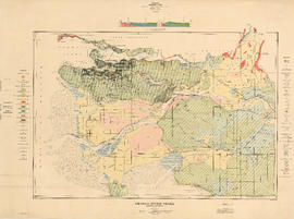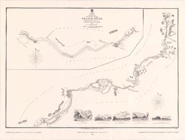
Sketch of the upper part of the Fraser River from Langley to Yale
- AM1594-: MAP 948
- Item
- 1984
Part of City of Vancouver Archives technical and cartographic drawing collection
Item is a modern reproduction of an Admiralty map showing landmarks, geographic features and First Nations settlements along the upper part of the Fraser River from Langley to Yale. The map includes five illustrations of various locations along the river, which correspond to locations noted on the map. The illustrations are labeled: View A - Fort Yale, View B - Emery Bar, View C - Mouth of the Quequealla (Coquihalla River?), View D - Cornish Bar and View M - Entrance of river, Mount Blanchard in the distance.
United Kingdom. Admiralty