![High water Town Line Rd., Oct. -21 [Maple Ridge, B.C.]](/uploads/r/null/a/b/ab3fb59ec59f70237ee2df08862965f868577084dcd6e4e7b2b5b39b0cd54567/d69062c6-df22-4037-a54c-7cb9b333236d-A03896_142.jpg)
High water Town Line Rd., Oct. -21 [Maple Ridge, B.C.]
- AM336-S3-1-: CVA 677-1097
- Item
- Oct. 1921
Photograph shows people standing beside a car on flooded Town Line Road.
18 results with digital objects Show results with digital objects
High water Town Line Rd., Oct. -21 [Maple Ridge, B.C.]
Photograph shows people standing beside a car on flooded Town Line Road.

Up Carr's Hill River Road nr. Haney

Photograph shows a dirt road in Stanley Park..
![[Road through Stanley Park]](/uploads/r/null/2/b/2bf63f78ee7e8f65d5fd6d82cf3e6f597034a44a831f7a708d4c1cea55004b09/9b88704b-7c71-4e4d-bfcb-dbce0b164ca2-A01900_142.jpg)
Photograph shows a dirt road, diverging at two large trees. Photograph also shows individuals on a walking path next to the road.

Marine Drive, North Shore, Vancouver, B.C.
Photograph shows a car in the bend in the road.
![Park Avenue [later Boundary Road], Burnaby [showing streetcar, overpass, road, and sidewalk]](/uploads/r/null/2/b/2b74ed29786ac213728ca27f25142ac847f53471f23f41589a716ae0090e6aa7/9bd6377d-965a-4e07-bbc5-746fce64a1f3-A02667_142.jpg)
Park Avenue [later Boundary Road], Burnaby [showing streetcar, overpass, road, and sidewalk]
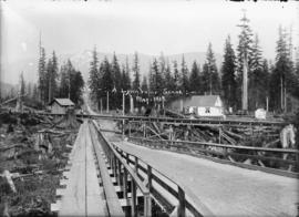
Photograph shows an elevated road and sidewalk running north under a flume. Photograph also shows houses and tree stumps.

Pipe line road, Lynn Creek, B.C.
Photograph shows muddy dirt road extending to mountain, a shack, and an elevated plank sidewalk next to the road.

The pipe line road. Lynn Valley, B.C.
Photograph shows two men waiting for an approaching streetcar. Photograph also shows road, houses, and trees, and the mountains in the background.
![[Road into Stanley Park, covered in snow]](/uploads/r/null/1/0/10cad8d9ec5eeece7b42b9d0b61296a35a18b91781fd9b796627b129d772d0d6/a55591bc-0658-4a75-93db-8828a0c53f71-A02310_142.jpg)
[Road into Stanley Park, covered in snow]
Photograph shows road, trees, and Vancouver Yacht Club building.
![[Plank road and flume] between Sugdens and George Streets, Lynn Valley](/uploads/r/null/d/f/df03f489a5119820bf2f7e50e409932a1c4ac87aa7207a37ea12f291989561eb/698eb6d2-5a3b-4449-bdd9-6dda4b06b81a-A02705_142.jpg)
[Plank road and flume] between Sugdens and George Streets, Lynn Valley
Photograph shows road, flume, and tree stumps.

Corner Pipe Line and Fromme Road, Lynn Valley, B.C.
Photograph shows intersection of two roads, and surrounding trees and stumps. Photograph also shows a signpost indicating the corner of Fromme and Lynn Valley Roads.

On the pipeline in 1909. Lynn Valley, B.C.
Photograph shows road, parallel plank sidewalk, and trees.
![[Dirt road]](/uploads/r/null/2/a/2aa9f97f17e5cd1534bc4bf2e67053e31e527fd22b70039e024e007bc506e743/02fc35f0-5625-4c4d-8aaf-69a021c733bf-A01976_142.jpg)
![[Road through Stanley Park]](/uploads/r/null/b/6/b6d78b72fb5195f26e1f9ffaf3b56d5127bd82fc20d81395d29499f8a117f02e/1e726f00-aaa5-437f-b8c4-c17c76df821f-A02571_142.jpg)
![[Road through Stanley Park]](/uploads/r/null/8/3/832c013d4d0e3fb97a0bf5f8a3a311f1651b3f2dec207708cbf9ad5c16276581/c5e4f758-c04e-43ac-b7fd-b266e2b4e017-A02573_142.jpg)

Photograph shows two cars parked on road with cliffs on either side and the sea in the horizon.

Photograph shows a car parked at the bend of a dirt road, with the cliff on one side and the sea on the other.