A plan for the City of Vancouver, British Columbia
- COV-S697--
- File
- 1929
Part of City of Vancouver fonds
Harland Bartholomew and Associates
6 results with digital objects Show results with digital objects
A plan for the City of Vancouver, British Columbia
Part of City of Vancouver fonds
Harland Bartholomew and Associates
Civic centre : Proposed development for the Burrard Street site
Part of City of Vancouver Archives technical and cartographic drawing collection
Item is an oblique perspective rendering of a proposed civic centre development adjacent to the north end proposed Burrard Street Bridge (approximately the area bounded by the existing Davie, Burnaby, and Bute streets and English Bay).
Harland Bartholomew and Associates

General development plan, Exhibition Park, Vancouver, B.C.
Part of City of Vancouver Archives technical and cartographic drawing collection
Item is a map showing the Exhibition Park site, with existing buildings, proposed buildings (immediate program), proposed buildings (future program), building names and parking lot capacities.
Harland Bartholomew and Associates

Greater Vancouver, British Columbia : regional major street plan
Part of City of Vancouver Archives technical and cartographic drawing collection
Item is a map which has been removed from a copy of the report "A plan for the City of Vancouver, British Columbia, including Point Grey and South Vancouver and a general plan of the region", commissioned by the Vancouver Town Planning Commission from the planning consultants Harland Bartholomew & Associates.
The map shows existing and proposed additions to the Greater Vancouver major street plan.
Harland Bartholomew and Associates
Procedure to be followed in making land use survey
Part of City of Vancouver fonds
Harland Bartholomew and Associates
Railway and harbour report, Vancouver, B.C.
Part of City publications collection
Item is a report submitted to the Vancouver Town Planning Commission which includes the following sections: Canadian Pacific Railway; North Shore Yards; Industrial Development; Uniform Switching Rates Possible with Terminal Company; Joint Use of Railway Facilities; Interchange Methods; Grade Crossing Elimination; Promotion of Industrial Development; Disposition of False Creek Channel; Canadian National Railway; Great Northern Railway; British Columbia Electric Railway; Harbour Commission's Terminal Railway; Grain Movement to Burrard Inlet Elevators; etc. The report has attached four charts and four maps.
Harland Bartholomew and Associates
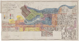
Schedule 'A': Plan of the City of Vancouver
Part of City of Vancouver fonds
Item is a map depicting by colour the zoning categories defined by the by-law and the city lots and blocks covered by each zoning category. The map covers only the "old" (pre-amalgamation) City of Vancouver.
Vancouver Map & Blue Print Company

Vancouver, British Columbia : northerly portion, former City of Vancouver : major street plan
Part of City of Vancouver Archives technical and cartographic drawing collection
Item is a map which has been removed from a copy of the report "A plan for the City of Vancouver, British Columbia, including Point Grey and South Vancouver and a general plan of the region", commissioned by the Vancouver Town Planning Commission from the planning consultants Harland Bartholomew & Associates.
The map shows the existing and proposed revisions to the major street plan in the northern portion of Vancouver. The map also shows present street widths, lines of vehicles and roadway widths versus proposed street widths, lines of vehicles and roadway widths.
Harland Bartholomew and Associates

Vancouver, British Columbia : south-westerly portion, formerly Point Grey : major street plan
Part of City of Vancouver Archives technical and cartographic drawing collection
Item is a map which has been removed from a copy of the report "A plan for the City of Vancouver, British Columbia, including Point Grey and South Vancouver and a general plan of the region", commissioned by the Vancouver Town Planning Commission from the planning consultants Harland Bartholomew & Associates.
The map shows existing and proposed additions to the major street plan in part of the city that is the former Municipality of Point Grey. The map also shows present street widths, lines of vehicles and roadway widths versus proposed street widths, lines of vehicles and roadway widths.
Harland Bartholomew and Associates

Vancouver, British Columbia, south-easterly portion, formerly South Vancouver : major street plan
Part of City of Vancouver Archives technical and cartographic drawing collection
Item is a map which has been removed from a copy of the report "A plan for the City of Vancouver, British Columbia, including Point Grey and South Vancouver and a general plan of the region", commissioned by the Vancouver Town Planning Commission from the planning consultants Harland Bartholomew & Associates.
The map shows major streets of sufficient width, major streets to be widened, new major street connections, present street widths, present lines of vehicles, present roadway widths, proposed street widths, proposed lines of vehicles, proposed roadway widths and pleasure drives in the area of the former Municipality of South Vancouver.
Harland Bartholomew and Associates