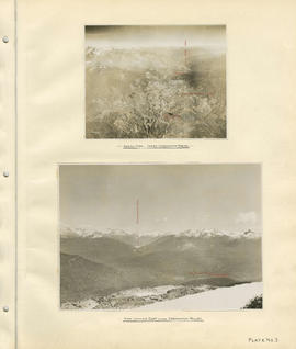
Aerial view - Lower Cheakamus Region and View looking east across Cheakamus Valley
- COV-S40-MAP 939-: LEG1153.036
- Item
- [1931]
Part of City of Vancouver fonds
97 results with digital objects Show results with digital objects
Aerial view - Lower Cheakamus Region and View looking east across Cheakamus Valley
Part of City of Vancouver fonds
![[Capilano Creek bed]](/uploads/r/null/2/2/227b0d99829332483179bd56e99f24100998eda4ede1212c1623a46196f25ea6/a2ffcc43-9e50-4836-8f91-054a507db579-A16535_142.jpg)
Part of City of Vancouver fonds
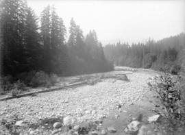
Photograph shows dry creek bed and trees.
![Capilano [Creek] beneath [retaining?] wall at south end, looking eastward](/uploads/r/null/8/2/82c3a40e01fe7a1d90487e7f21e0c3205a6f0dac00ec239d9734f1d0950e13f3/6cfcf3fc-01c4-42b5-bbab-85e8207ca5ad-A16532_142.jpg)
Capilano [Creek] beneath [retaining?] wall at south end, looking eastward
Part of City of Vancouver fonds
![Capilano [Creek] looking upstream from north part of island](/uploads/r/null/a/8/a896dc9c2db3c65159f7e2771c98e330ea3c12b91907157c4698e756dbb1826c/b3e6f5a4-4ff6-456c-84bb-263e82325018-A16531_142.jpg)
Capilano [Creek] looking upstream from north part of island
Part of City of Vancouver fonds
![Capilano Creek [retaining?] wall looking downstream from main channel](/uploads/r/null/e/9/e9025ee05e55eced3e5a22e02e43baa41014dc7b514c53ef148e7e1c1c1f422e/f80f573a-1a6d-45ce-9b5e-3f32a0f192e6-A16530_142.jpg)
Capilano Creek [retaining?] wall looking downstream from main channel
Part of City of Vancouver fonds
![Capilano [Creek] West Channel looking upstream from lower end](/uploads/r/null/1/1/119d1142158a2f8850f1a5e9d3775af1d6018a3291f1f2d51ee974cad3d03416/ddc2b9d6-276b-4887-9393-165796e72cef-A16533_142.jpg)
Capilano [Creek] West Channel looking upstream from lower end
Part of City of Vancouver fonds

Part of City of Vancouver fonds
Part of City of Vancouver fonds

Part of City of Vancouver fonds

Part of City of Vancouver fonds

Capilano lower section of retaining wall
Part of City of Vancouver fonds
Part of City of Vancouver fonds
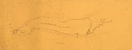
Item is a map showing the results of a preliminary survey of Cheakamus Lake and surrounding terrain. This map appears to be a draft of potions of the base map for MAP 1077.01, MAP 1077.02 and MAP 1119.

Cheakamus power survey : copy of portion of plan no. 11 accompanying report by E.A. Cleveland
Part of City of Vancouver fonds
Map is a topographical plan showing elevations and the location of power houses, dams, pipelines, tunnels and railways as well as mountains, glaciers, creeks and lakes in the Garibaldi Lake area. The map shows the area approximately between the Cheakamus River in the west and Pitt River in the east, and between Green Lake in the north and Rampart Lake in the south.
The map is a tracing of a portion of one of the maps created by E.A. Cleveland in 1931 and was included in the appendix to his report to the City of Vancouver on the hydro-electric capacity of the Cheakamus River system (the atlas of maps accompanying the Cleveland report is MAP 939). Sheet 11 of that atlas was a copy of the map Topographical map of Garibaldi Park, published by the British Columbia Department of Lands in 1928, a copy of which had been used as a base map to note elements of the Cheakamus River hydro-electric survey.

Cheakamus power survey for City of Vancouver 1930-1931. General plan and profile
Part of City of Vancouver fonds
Item is a map depicting south-western British Columbia and noting the location of the area covered by the plates in the atlas. The sheet also includes a profile of the survey area from Cheakamus Lake to Garibaldi Lake.

Part of City of Vancouver fonds
Item is a group of charts depicting flows by month measured at various points along the Cheakamus River.

Part of City of Vancouver fonds
Item is a sheet depicting a topographical map of the planned development from Garibaldi Lake to Daisy Lake. The sheet also includes a profile along the proposed tunnel and pipeline route.

Part of City of Vancouver fonds
Item is a topographic map of Cheakamus Lake, showing elements of the proposed power infrastructure. The map also includes an inset topographic map of the proposed dam site and a capacity diagram of Cheakamus Lake.
Part of City of Vancouver fonds
Item is a map sheet containing three topographical maps, depicting the Cheakamus River and Brandywine Creek, the dam site at Brandywine Creek ,and the proposed dam site near McGuire. The sheet also includes sectional drawing of the McGuire dam site, as well as charts of pondage at McGuire and Brandywine.

Part of City of Vancouver fonds

Cheakamus power survey for City of Vancouver 1930-1931. Proposed storage reservoir at Daisy Lake
Part of City of Vancouver fonds
Item is a map sheet containing two maps depicting portions of the Cheakamus River at or near Daisy Lake, with proposed power infrastructure. The sheet also contains charts depicting a capacity diagram for Daisy lake reservoir and cross-sections at Dyke #1 and Dyke #2.
Part of City of Vancouver fonds
Item is a map which appears to depict a proposed route for a pole line from a power house on the Cheakamus River to the Squamish River, as well as other unidentified sketches.
Cheakamus River. Brandywine Creek to Cheakamus Lake
Part of City of Vancouver fonds
Item is a rough preliminary sketch map of part of the Cheakamus River. The map includes notes on terrain, survey data points, the PGE railway right of way, and District Lots.

Cheakamus River valley with possible dam location
Part of City of Vancouver fonds
Item is a sheet with three maps depicting a possible dam site on the Cheakamus River: a topographical map of the site with the dam location annotated, a cross-section depicting the geology of the dam site, and a profile of the tentative location of a tunnel.

Cheakamus River with proposed dam site at McGuire
Part of City of Vancouver fonds
Item is a sheet with three maps depicting a possible dam site on the Cheakamus River near McGuire: a topographical map of the site with the dam location annotated, and a cross-section depicting the geology of the dam site.
Chehalis River and Harrison Lake
Part of City of Vancouver fonds
Item is a map sheet containing draft or preliminary versions of maps of the Chehalis River and Harrison Lake, relating to surveys conducted by H. Idsardi.

Chilliwack Lake scheme & Jones Lake scheme
Part of City of Vancouver fonds
Item is a map depicting proposed hydro-electric development north-west of Chilliwack Lake. The map shows the location so proposed dams, flumes, tunnels and the location of a power house on the Fraser River west of Jones Lake.
Part of City of Vancouver fonds
Item is a map sheet showing a map, traverse data, cross-section from Chilliwack Lake to the BC Electric Railway line west of Cultus Lake.
Part of City of Vancouver fonds
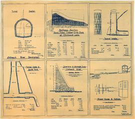
Item is an architectural drawing sheet with six drawings related to proposed hydro electric development on the Chilliwack River: Tunnel section; Spillway section-rock-filled timber crib dam at Chilliwack Lake; Tunnel intake; Tunnel outlet & surge tank; Diversion & storage dam; and Power house and tailrace. Each drawing includes cost and quantity estimates for construction materials.

Contour map shewing proposed location of flume, reservoir and power plant Cheakamus River, B.C.
Part of City of Vancouver fonds
Item is a copy of a map that appears to have been created as part of power development proposal by DuCane, Dutcher & Co. The map was likely acquired by the City Engineer's Office as a reference map for surveying work done in the Cheakamus River area in 1923.

Contours in Chilliwack Valley near Chipmunk Run
Part of City of Vancouver fonds
![[Cribbing on road at edge of Capilano Creek]](/uploads/r/null/a/3/a359362e8107f6a8feb33a5b82762ea3906af278d6f024af920dd189ce5d2593/ba3f6329-5973-4d12-96d2-90a0a3909935-A16597_142.jpg)
[Cribbing on road at edge of Capilano Creek]
Part of City of Vancouver fonds
Photograph shows what may be Capilano Hotel in background.
Part of City of Vancouver fonds
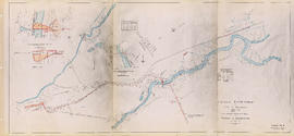
Item is a map sheet containing three small rough preliminary sketch maps: one topographic sketch of a small stretch of an unidentified creek, one topographic sketch of Daisy Lake and immediate area, and a topographic sketch of a section of Stoney Creek.

Part of City of Vancouver fonds
Item is a map sheet containing two profiles: one showing the increased reservoir height with a subsidiary dam built and the other a profile of the proposed subsidiary dam site.

Garibaldi Lake, Daisy Lake and Cheakamus River
Part of City of Vancouver fonds
Item is a sheet containing the following survey photographs: Stillwater below Daisy Lake; Looking up Cheakamus River from canyon dam site; Leakage from Garibaldi Lake through lava into Garibaldi Creek; Looking up-stream from near Cheakamus Canyon power station; Looking up Cheakamus River from P.G.E. Rlwy. bridge Mile 19.1; Looking up Cheakamus River to Daisy Lake dam site; Looking down Cheakamus river from canyon dam site.
![General plan [of hydro-electric development on Green River]](/uploads/r/null/d/9/e/d9e4c58e28a2189f0c1819b9c491a0478fad0353e2100858ec1eb94c55b96eae/93fa8e5f-c3b7-4e51-802d-979b7bc07f6f-MAP1098_142.jpg)
General plan [of hydro-electric development on Green River]
Part of City of Vancouver fonds
Item is a sheet containing a map of the proposed development and an elevation of the site, showing the dam, tunnel and powerhouse.

General plan of proposed development of Alouette water power
Part of City of Vancouver fonds

Part of City of Vancouver fonds
Item is an architectural drawing sheet depicting a plan and section of the intake on the Bridge River, and the power house on Seton Lake.

General plan of works to be constructed at Nairn Falls. Green Lake. Lillooet District, B.C.
Part of City of Vancouver fonds
Item is a topographical map showing the location of proposed power house, dam and other hydro-electric infrastructure at the north end of Green Lake, tunnel, and the Pacific Great Eastern Railway right-of-way along the northern edge of Green Lake.
Part of City of Vancouver fonds
Item is a portion of a topographical map showing Green Lake, the headwaters of the Green River, and the portions of 21 Mile Creek and Fitzsimmons Creek where they empty into Green Lake. The remaining portion of the map shows the Green Lake area from District Lot 2015 to 3336. The map is missing its right-hand portion and title block, though the style and hand are the same as other maps created by the City Engineer's Office as a result of the 1923 surveys of the Squamish, Cheakamus and Green rivers.
The sheet also contains three sections: one of Fitzsimmons Creek at the Pacific Great Easter Railway bridge 40.5, one of the Green River and one of the valley north-west of Green Lake along which the PGE line runs.

Head of Callaghan Creek and Lower Callaghan Lake
Part of City of Vancouver fonds
Hydro electric schemes. Squamish River
Part of City of Vancouver fonds

Hydro electric survey. Cheakamus River from Squamish River to Brandywine Creek
Part of City of Vancouver fonds

Hydro electric survey City of Vancouver : Cheakamus River system from Squamish River to Green River
Part of City of Vancouver fonds
Item is a map which shows a proposed hydro electric development of the Cheakamus River system from the Squamish River to Green Lake. The map includes proposed tunnel routes, diversions, storage reservoirs, dams, power houses, canals, and pipelines. Also shown are areas of suggested future development and the Pacific Great Eastern railway line. Included in the area surveyed are Garibaldi Lake, Starvation Lake, Deadman's Lake, Daisy Lake, Stoney Lake, Cheakamus Lake, Alta Lake, Nita Lake, Alpha Lake, and Green Lake, as well as the Squamish River, Pilchuk River, Cheakamus River, Soo River, Green River, and various creeks.

Hydro electric survey City of Vancouver : Cheakamus River system from Squamish River to Green River
Part of City of Vancouver fonds
Item is a map which shows a proposed hydro electric development of the Cheakamus River system from the Squamish River to Green Lake. The map includes proposed tunnel routes, diversions, storage reservoirs, dams, power houses, canals, and pipelines. Also shown are areas of suggested future development and the Pacific Great Eastern railway line. Included in the area surveyed are Garibaldi Lake, Starvation Lake, Deadman's Lake, Daisy Lake, Stoney Lake, Cheakamus Lake, Alta Lake, Nita Lake, Alpha Lake, and Green Lake, as well as the Squamish River, Pilchuk River, Cheakamus River, Soo River, Green River, and various creeks. Map is hand coloured with pencil annotations concerning watersheds, land height and creeks not included on the original map design.
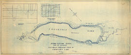
Hydro electric survey. Plan showing preliminary survey of Cheakamus Lake
Part of City of Vancouver fonds
Item is a topographical map showing a preliminary hydro electric survey of Cheakamus Lake, including a capacity diagram of Cheakamus Lake with dam at Section A-B and a cross-section on that line. The sheet includes a graph depicting the capacity of Cheakamus Lake with dam at section A-B. The map includes the Cheakamus River, creeks, characteristics of the terrain, elevations, and water level. Certified correct by Charles W. Williams.
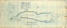

Hydro electric surveys. Plan showing location of water powers investigated by City of Vancouver
Part of City of Vancouver fonds
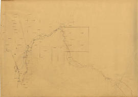
Item is a map which shows the locations and the dates of use of "gauging stations established" and "city gauging stations still in use" in the area of south-western British Columbia where the City of Vancouver conducted hydro-electric surveys up to 1923.

Hydro electric surveys. Plan showing location of water powers investigated by City of Vancouver
Part of City of Vancouver fonds
Item is a map which functions as a visual index to the locations of various hydro electric surveys carried out by the City of Vancouver along the following rivers: Squamish River, Cheakamus River, Green River, Lillooet River, Eagle River, Indian River, Pitt River, Chehalis River, Harrison River, Chilliwack River, the Fraser and Thompson Rivers, and Bridge River. The map lists the names of the surveyors responsible and the areas covered by each survey. Annotations include the locations and the dates of use of "gauging stations established" and "city gauging stations still in use."

Hydro electric surveys. Preliminary plan of Brandywine Creek
Part of City of Vancouver fonds
Item is a map which shows the results of a survey of the hydro-electric capacity of a section of Brandywine Creek, a tributary of the Cheakamus River north of Squamish, B.C. (D.L. 4098 and D.L. 4100]. The map depicts elevations, creek beds, gravel bars, flat areas, waterfalls, benches, wagon road and the Pacific Great Eastern Railway line. The map includes two cross-section maps of areas A-A and B-B. Notes on the map indicate that the elevations given are the height above the Pacific Ocean, and that Great Eastern Railway datum was used.