Sectional map and street directory of Vancouver : Dial map of the city of Vancouver including adjacent municipalities
Sectional map and street directory of Vancouver : Dial map of the city of Vancouver including adjacent municipalities
Sectional map and street directory of Vancouver : Dial map of the city of Vancouver including adjacent municipalities
Sectional map and street directory of Vancouver : Dial map of the city of Vancouver including adjacent municipalities
![North Shore Marine Drive [and] Point Atkinson, Vancouver, B.C., Canada](/uploads/r/null/b/3/1/b31126992eefcb817ddcd71e986e554566c5a7384d9b78337c6b98c541189b86/86aad77d-e1bb-4799-b9d0-da385dffbff1-AM1052P-2170_142.jpg)
North Shore Marine Drive [and] Point Atkinson, Vancouver, B.C., Canada

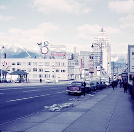
Hastings Street , Vancouver, B.C.
![[Parade for the Miss Kerrisdale pageant]](/uploads/r/null/e/9/e99fe13f5768f69a192dd2705219afa01a6ea67c2a8e6aab0cbab8cd52d8a582/aa6aec4a-c968-4e40-8a97-9caf31af6295-A72344_142.jpg)
[Parade for the Miss Kerrisdale pageant]

B.C. Electric guide to Greater Vancouver : Richmond transit system, downtown Vancouver transit system, street index, and general information

Nelson Street - King's Lynn
![[View of the west side of the 900 block Nicola Street looking north]](/uploads/r/null/3/f/3f551961c7ecf691e653986ffb948f335f7c23556a1e7b10eb5d0e404ceb6a3e/f2ee32ec-aba4-4937-adcd-449b2af40772-A25035_142.jpg)
[View of the west side of the 900 block Nicola Street looking north]
![[Parade for the Miss Kerrisdale pageant]](/uploads/r/null/2/1/210e60841274bc776202391f2aee1b4524c9ee090a9559e8d7ce0729d701a9bc/bd622fa8-2b75-4e4f-80c1-02f27f6a60d7-A72342_142.jpg)
[Parade for the Miss Kerrisdale pageant]
![B.C. Electric [Hydro Building - 970 Burrard Street under construction]](/uploads/r/null/0/4/048a598c0484e07c09746fcbd1d195b27aca7c408c10eb4759059774f1bc2f59/2f77bbb5-e09b-4dd7-abf7-b339c90d030d-A25112_142.jpg)
B.C. Electric [Hydro Building - 970 Burrard Street under construction]
Vancouver, British Columbia, Canada : one way streets in force Aug. 26th, 1957
Vancouver, British Columbia, Canada : one way streets in force Aug. 26th, 1957
Metropolitan areas of Vancouver and Victoria, B.C. road map
Metropolitan areas of Vancouver and Victoria, B.C. road map
Map of Greater Vancouver including streets, districts, schools, churches, shopping centres, parks, etc.
Map of Greater Vancouver including streets, districts, schools, churches, shopping centres, parks, etc.

Street map of Greater Vancouver, B.C.

Map of West Vancouver and North Vancouver, street index, real estate information, and list of golf courses
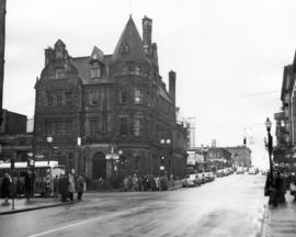
![[View looking north from City Hall]](/uploads/r/null/3/7/3719510f814648ae0b2e7b0ce76d43a412104e50f0c080895fe1c0a328907de6/96db8e82-b144-4bfe-9fe2-c74239a3f26b-A43298_142.jpg)
[View looking north from City Hall]
![[Exterior of the Post Office - 701 West Hastings Street]](/uploads/r/null/5/8/58224251a9af8ba99d33b9374ab6832ca82fa44b0542cea2875d2cd84b55a7c4/82d70554-e806-4944-9ed2-79cddf87f35e-A25107_142.jpg)
[Exterior of the Post Office - 701 West Hastings Street]
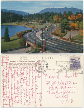
Entrance to Stanley Park (causeway)
Sectional map and street directory of Vancouver : Dial map of the city of Vancouver
Sectional map and street directory of Vancouver : Dial map of the city of Vancouver
![[View of the south side of the 2000 Block of West 41st Avenue]](/uploads/r/null/3/1/3157128d66c09ac31b2fd2583aa8019746e566f6d2e843b63ff3903185799fd9/c1a74d4f-84af-443b-a1a8-acf3c74c07ca-A72302_142.jpg)
[View of the south side of the 2000 Block of West 41st Avenue]
![[View of the southwest corner of Maple Street and 41st Avenue]](/uploads/r/null/7/3/73411443ca048442ffaad48546f286d13790abca4b24b2d856a094cfbbf4d181/9ab1051a-565f-4ac7-b052-eac78d5a5214-A72303_142.jpg)
[View of the southwest corner of Maple Street and 41st Avenue]
![[View of Stanley Park causeway]](/uploads/r/null/1/4/1400cb0870559e653058060d461a4c40f2d71d31f5a272b7b5cc27f422df06ba/1012a3da-487c-41b2-97a3-2acab239d2bb-A71130_142.jpg)
[View of Stanley Park causeway]
Looking north from Bowell-McLean Motor Co. Ltd. at 615 Burrard Street
![[The Eaton's of Canada float in the 600 Block of Granville Street in the Grey Cup Parade]](/uploads/r/null/7/9/79d132f120bd23aff7dae0ecb1f23471bab3aa83f6a24a5fea35064279445606/1fe078a1-8dfd-4fbf-9c80-478749eab632-A61194_142.jpg)
[The Eaton's of Canada float in the 600 Block of Granville Street in the Grey Cup Parade]
![Bldgs. [Buildings on the north side of the 600 block of Hastings St.]](/uploads/r/null/6/4/64b973f3b3c9cb2b4aacf7687a576bcdb575fe8a8d0778960483abc44eac347c/96dcae5c-a1ef-4954-9ed8-36549a7fa8f8-A21867_142.jpg)
Bldgs. [Buildings on the north side of the 600 block of Hastings St.]
600 block of Granville Street
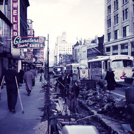
![[View of 100 block West Cordova Street, south side, looking east]](/uploads/r/null/0/d/4/0d42b77e9d578c3c8554b3640a7d3f27a72839fab0ec6e4eb805d16de90285b8/abd54da6-9198-4386-9052-c77e37baf43d-CVA480-332_142.jpg)
[View of 100 block West Cordova Street, south side, looking east]

Hastings and Vernon Dr.
![Bank of Commerce Hastings and Hamilton [Streets]](/uploads/r/null/c/f/cf874cf3b2915734b221c4d0203386cbb04ac0be490101394f410352919c3a7b/b92ac7da-fc6d-4a66-8779-8ad7cc01928e-A21872_142.jpg)
Bank of Commerce Hastings and Hamilton [Streets]
![Imperial Bank [of Canada - 586 Granville St.]](/uploads/r/null/6/d/6d29e7155e220086ee27fd26ceae98ea1110c77b0f1b3ae08df45462b70261b9/6cfa10b2-0b8e-4bd5-9fc4-94f1d7a49a1a-A21871_142.jpg)
Imperial Bank [of Canada - 586 Granville St.]
[Exterior of the Imperial Bank of Canada (formerly Bank of Montreal) on the northeast corner of Granville Street and Dunsmuir Street]
![[Fairmont Road washed out after the storm]](/uploads/r/null/f/d/fdac97656d097c1db744ea7ebff607ce140d236c2c466c08c6de0f6317783415/616b630a-7f25-40f6-9722-b0b838b2a7aa-A33735_142.jpg)
[Fairmont Road washed out after the storm]

Intersection at West Hastings and Burrard Streets
![Granville [Street] and Georgia [Street] looking north](/uploads/r/null/7/a/7a8f8d400666761c78aa31d135b120372695fb96e6be2e0d510d5272524258bb/75bbeab0-adb5-4c2d-b9ed-db368bc59dad-A44929_142.jpg)
Granville [Street] and Georgia [Street] looking north

Visitors map of Vancouver ; world famous Stanley Park ; downtown Vancouver

Street map of Vancouver
![Commercial Dr. [1100 block]](/uploads/r/null/a/6/a6812284557e58d94a65780c0ea1dfe43d4e6d9800bc40420c39894a17a4e120/ff274150-6cf1-4cba-aa50-993a2b5529f4-A21864_142.jpg)
Commercial Dr. [1100 block]
![Looking east on Hastings [Street] from Howe [Street]](/uploads/r/null/e/a/ea05aa39c0a46ee21345d98715647bb2bf402993c2372614cb432f6f412c69fa/94567666-7917-46cd-ab03-909b4d48e8ca-A49843_142.jpg)
Looking east on Hastings [Street] from Howe [Street]
![[Granville St. at Hastings St., looking south]](/uploads/r/null/3/f/3f5c9c270d59846d9552f5e5c9c93dd128d30ad0698afa539c75b12d1c38afc0/93642b9d-f977-478f-9940-f53ece9cdca0-A43717_142.jpg)
[Granville St. at Hastings St., looking south]

Visitors map of Vancouver
Sectional map and street directory of Vancouver : Dial map of the city of Vancouver
Sectional map and street directory of Vancouver : Dial map of the city of Vancouver
![Commercial Dr. [and Napier Street]](/uploads/r/null/d/d/dd78f6946be88c111510b4b9c592029fe585d9eebe78a05eb707be8f5d27a525/5e0f7c01-038b-4d82-8fde-57092224de9e-A21865_142.jpg)
Commercial Dr. [and Napier Street]
![Commercial Drive a[t] 2nd Ave](/uploads/r/null/c/1/c11d20207674653e27261ccee1a0049c388d60ff0e39ac00e2be3db2906ae3c2/75a17f2f-80e3-4991-8f72-b049746747b4-A21866_142.jpg)
Commercial Drive a[t] 2nd Ave

[View of the new Post Office construction site looking towards Georgia between Hamilton and Homer Streets]

Sheet S.V. 4 : Ash Street to St. George Street and Fifty-first Avenue to Sixty-third Avenue

Sheet S.V. 8 : Prince Edward Street to Argyle Street and Forty-seventh to Fifty-eighth Avenue

Sheet S.V. 15 : Dawson Street to Boundary Road and Foster Avenue to Fiftieth Avenue

Sheet S.V. 11 : Fleming Street to Killarney Street and Thirty-seventh Avenue to Forty-eighth Avenue

Sheet S.V. 7 : Prince Edward Street to Argyle Street and Thirty-fifth Avenue to Forty-seventh Avenue

Sheet S.V. 9 : St. George Street to Argyle Street and Fifty-eighth Avenue to Fraser River