Print preview Close

Showing 6150 results

Archival description
Streets
Print preview View:

6048 results with digital objects Show results with digital objects

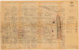
City of Vancouver redevelopment : project 1, area A-1 : detailed plan of redevelopment

Item is a map showing housing types, new streets and lanes, easements, and buildings to be retained as part of Project 1, and the boundaries of areas A1.1, A1.2, and A1.3. Base map shows streets, outlines of buildings, and topographic contour lines for the area from Main Street to Glen Drive and Alexander Street to Atlantic Street.

[Aerial view of Mount Pleasant, South Strathcona and Kensington-Cedar Cottage]

Photograph shows aerial view of the east end of False Creek, Thornton Park, Great Northern Railway and Canadian National Railway yards, Mount Pleasant, Strathcona, Grandview-Woodland, Trout Lake, Kingsway, Vancouver Technical School grounds, Renfrew playing fields, John Hendry Park, British Columbia Electric Railway Right of Way, Clark Park, Grandview Highway South, Great Northern Railway.

[A.W.A. Phair album]

File is album of photographs of Lytton, Lillooet (including street views, St. Mary's Church, Indian Church, Pimer Hotel and a stagecoach), Cayoosh Creek, Duffy Lake, Vancouver (including the Court House and a Japanese Arch on Hasting Street) and other locations in British Columbia. People identified: Frank Gott, Pete Rebagliati, Cottrell Hope and McGillivray's place

Spokane and Red Mountains, showing Le Roi Mine from Columbia Ave. Rossland

Sites and buildings identified: 1. Spokane Mt., 2. Le Roi Mine, 3. War Eagle Mine, 4. Centre Star Mine, 5. Nickle Plate Mine, 6. Red Mt., 7. Columbia Ave., 8. Spokane St., 9. Travers Hardware, 10. Ritchie Blk., 11. Jas. Price Tailor, 12. Stussi's Store & Post Office, 13. Shirley Bakery, 14. Pacific Hotel, 15. Grand Hotel, 16. Clifton Hotel, 17. Edgren's Store.

Vancouver, B.C., Canada

Item is a postcard showing a rood-top view of Granville Street. Caption on the back of postcard: "Night owl's roof-top view of Granville Street. The B.C. Hydro Building and environs are an impressive sight at night. The waters of English Bay can be seen in the background, to the right."

Granville Street, Vancouver, B.C.

Item is a postcard printed with an image of Granville Street including the Orpheum, Vogue and Capitol. Caption on back of postcard: "Photo taken looking north on Granville Street, showing the theatre district with numerous neon signs. This street is the main street of Vancouver and extends from the wharf for a length of 10 miles, cutting the city in half." The back of the postcard includes personal correspondence addressed to Holmes and Shelley.

Entrance to Stanley Park (causeway)

Item is a postcard showing the causeway entrance to Stanley Park. Caption on back of postcard: "The park comprises 1,000 acres of natural playground, home of the Theatre Under the Stars, the Zoo, Shakespearian Gardens, picnic grounds, Vancouver, B.C." The back of the postcard includes personal correspondence addressed to Miss C. Smith.

Results 4351 to 4400 of 6150