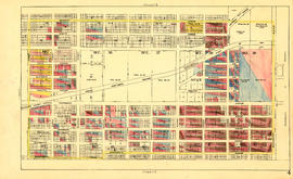
Sheet 22 : Stanley Park to Burrard Street and waterfront to Robson Street
- AM1594-MAP 779-: MAP 779.24
- Item
- Oct. 1945
Part of City of Vancouver Archives technical and cartographic drawing collection
Item is a section showing Stanley Park to Burrard Street and waterfront to Robson Street. Includes streets and roads; blocks, lots and legal descriptions. Map shows the locations of Stanley Park, Deadmans Island, marine filling stations, the dredged channel, harbour headline, C.P.R .yards and Pier A, businesses along the waterfront, government buildings, land leases and quit claims.
Vancouver (B.C.). Office of the City Engineer