
- AM1594-: MAP 828-: LEG1334.4
- Part
- 1957
Part of City of Vancouver Archives technical and cartographic drawing collection
Part contains an illustrated map of West Vancouver and North Vancouver showing major streets, mountains, rivers and creeks, and recreational attractions; a street index to the Greater Vancouver map on the other side of the sheet; a list of golf courses; and real estate information including a description of professional realtors, an amortization table, and calculations showing amounts paid in rent over many years.
![[Exterior of the Post Office - 701 West Hastings Street]](/uploads/r/null/5/8/58224251a9af8ba99d33b9374ab6832ca82fa44b0542cea2875d2cd84b55a7c4/82d70554-e806-4944-9ed2-79cddf87f35e-A25107_142.jpg)
![[View looking north from City Hall]](/uploads/r/null/3/7/3719510f814648ae0b2e7b0ce76d43a412104e50f0c080895fe1c0a328907de6/96db8e82-b144-4bfe-9fe2-c74239a3f26b-A43298_142.jpg)
![[View of the south side of the 2000 Block of West 41st Avenue]](/uploads/r/null/3/1/3157128d66c09ac31b2fd2583aa8019746e566f6d2e843b63ff3903185799fd9/c1a74d4f-84af-443b-a1a8-acf3c74c07ca-A72302_142.jpg)
![[View of the southwest corner of Maple Street and 41st Avenue]](/uploads/r/null/7/3/73411443ca048442ffaad48546f286d13790abca4b24b2d856a094cfbbf4d181/9ab1051a-565f-4ac7-b052-eac78d5a5214-A72303_142.jpg)
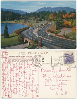
![[View of Stanley Park causeway]](/uploads/r/null/1/4/1400cb0870559e653058060d461a4c40f2d71d31f5a272b7b5cc27f422df06ba/1012a3da-487c-41b2-97a3-2acab239d2bb-A71130_142.jpg)
![Bldgs. [Buildings on the north side of the 600 block of Hastings St.]](/uploads/r/null/6/4/64b973f3b3c9cb2b4aacf7687a576bcdb575fe8a8d0778960483abc44eac347c/96dcae5c-a1ef-4954-9ed8-36549a7fa8f8-A21867_142.jpg)
![[The Eaton's of Canada float in the 600 Block of Granville Street in the Grey Cup Parade]](/uploads/r/null/7/9/79d132f120bd23aff7dae0ecb1f23471bab3aa83f6a24a5fea35064279445606/1fe078a1-8dfd-4fbf-9c80-478749eab632-A61194_142.jpg)
![[View of 100 block West Cordova Street, south side, looking east]](/uploads/r/null/0/d/4/0d42b77e9d578c3c8554b3640a7d3f27a72839fab0ec6e4eb805d16de90285b8/abd54da6-9198-4386-9052-c77e37baf43d-CVA480-332_142.jpg)

![Bank of Commerce Hastings and Hamilton [Streets]](/uploads/r/null/c/f/cf874cf3b2915734b221c4d0203386cbb04ac0be490101394f410352919c3a7b/b92ac7da-fc6d-4a66-8779-8ad7cc01928e-A21872_142.jpg)
![Imperial Bank [of Canada - 586 Granville St.]](/uploads/r/null/6/d/6d29e7155e220086ee27fd26ceae98ea1110c77b0f1b3ae08df45462b70261b9/6cfa10b2-0b8e-4bd5-9fc4-94f1d7a49a1a-A21871_142.jpg)
![[Fairmont Road washed out after the storm]](/uploads/r/null/f/d/fdac97656d097c1db744ea7ebff607ce140d236c2c466c08c6de0f6317783415/616b630a-7f25-40f6-9722-b0b838b2a7aa-A33735_142.jpg)

![Granville [Street] and Georgia [Street] looking north](/uploads/r/null/7/a/7a8f8d400666761c78aa31d135b120372695fb96e6be2e0d510d5272524258bb/75bbeab0-adb5-4c2d-b9ed-db368bc59dad-A44929_142.jpg)


![Looking east on Hastings [Street] from Howe [Street]](/uploads/r/null/e/a/ea05aa39c0a46ee21345d98715647bb2bf402993c2372614cb432f6f412c69fa/94567666-7917-46cd-ab03-909b4d48e8ca-A49843_142.jpg)
![Commercial Dr. [1100 block]](/uploads/r/null/a/6/a6812284557e58d94a65780c0ea1dfe43d4e6d9800bc40420c39894a17a4e120/ff274150-6cf1-4cba-aa50-993a2b5529f4-A21864_142.jpg)
![[Granville St. at Hastings St., looking south]](/uploads/r/null/3/f/3f5c9c270d59846d9552f5e5c9c93dd128d30ad0698afa539c75b12d1c38afc0/93642b9d-f977-478f-9940-f53ece9cdca0-A43717_142.jpg)

![Commercial Dr. [and Napier Street]](/uploads/r/null/d/d/dd78f6946be88c111510b4b9c592029fe585d9eebe78a05eb707be8f5d27a525/5e0f7c01-038b-4d82-8fde-57092224de9e-A21865_142.jpg)
![Commercial Drive a[t] 2nd Ave](/uploads/r/null/c/1/c11d20207674653e27261ccee1a0049c388d60ff0e39ac00e2be3db2906ae3c2/75a17f2f-80e3-4991-8f72-b049746747b4-A21866_142.jpg)


![[One way traffic Seymour St. at Georgia Street, looking south]](/uploads/r/null/6/a/6ab5722dd80ce8659c50534737b97713ef7378106e8777583f6504275d6eb353/28fb7cc1-f428-4efb-9354-3631dfad7020-A43714_142.jpg)
![[View of the last Vancouver Lulu Island inter urban tram near 41st Avenue and West Boulevard]](/uploads/r/null/c/7/c715e285bdfbbf1452f4d508f757efdd5a46b36dd8ebd2541123720536fe6b23/85e878f3-5c22-4418-858a-9f02c76bdd3f-A25954_142.jpg)
![[View of Cambie Street looking north from 49th Avenue]](/uploads/r/null/3/6/368e2de9261040b224898e9148ce0871a48d75a4d666f076fd9d75ef7226b951/1fcc0dd8-fa94-452a-91a9-555cc0174f23-A10280_142.jpg)
![[Northern view of East and West Boulevards from 41st Avenue]](/uploads/r/null/3/2/3286ca497b6ee711846e2170fe1ac12ecf59f59cffdd2b6f258a38607eeab617/0a3e79e1-c927-4059-9d19-3bf26fed9ad2-A25960_142.jpg)


![[Eastern view of 41st Avenue from East Boulevard]](/uploads/r/null/1/2/122c5971e183c9022cb9c0a3497f4d988373af58c89d857373c36e1410167faa/a4f74b60-6415-473b-8bb9-f791327e8a8e-A25961_142.jpg)
![[Looking west on 41st Avenue from Maple Street]](/uploads/r/null/8/7/87f1081cf37bab5ae5e0e7c862f01cb7b344015c41740a48283df8d5572f518a/ca978dbe-23e2-4048-a79a-89ca4333c950-A25956_142.jpg)
![[View of the first trolley bus in Kerrisdale at 41st Avenue and West Bouleverd]](/uploads/r/null/6/3/63a304dfd9591cc536701117321431f2b56e221ffcdd6686ecf9d94364c6b0ef/8630df3d-84ec-44aa-8cd7-dcc1e7ca9ca2-A25953_142.jpg)
![[Granville St. at Hastings St., looking south]](/uploads/r/null/a/2/a286ad43424d24fba08f581e54a465eeb391f36eb29ace65d92f0af5cb37c0f9/0b5bae2a-805d-4102-841b-ed894e819156-A43718_142.jpg)
![[View of Hastings Street looking west from Richards Street]](/uploads/r/null/0/1/012d9664d1474850ebc9e142ecf3f3ffd4bf50cde6134eb7be334d3762a5f7f7/1685247a-d5d0-4613-9d88-1104852faad4-A37231_142.jpg)
![[View of Cambie Street looking north from 45th Avenue]](/uploads/r/null/a/3/a300230d1538c4f855920a7835f1a5a079457965c7f96f0f366d818d06aab81d/05e20915-bf9c-49c4-8d3a-7120e6be17e1-A10278_142.jpg)
![[View of Cambie Street looking south from 41st Avenue]](/uploads/r/null/e/6/e67a5a2e77af574a261d54ff12e9b09998caa75945658582aec7399d6491335a/e0e01dc3-8422-4b5f-855c-78b2c312bcce-A10276_142.jpg)
![[View of Cambie Street looking south from 41st Avenue]](/uploads/r/null/b/3/b37c0397b99f41e571e2a73b5a0d2b5b208f3e67606a809d1ab2b4fd92e11fb7/816ee128-3b41-4917-a160-974e85d3a05c-A10277_142.jpg)
![[Granville St. at Hastings St., looking south]](/uploads/r/null/a/2/a2b150fdc2d0d1091b88dcb4036e315291c2712f91faf805ab8ed329a1a56990/cd90450d-d6b2-45e1-8810-c58b313df506-A43716_142.jpg)