
Map of West Vancouver and North Vancouver, street index, real estate information, and list of golf courses
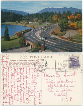
Entrance to Stanley Park (causeway)
![[Exterior of the Post Office - 701 West Hastings Street]](/uploads/r/null/5/8/58224251a9af8ba99d33b9374ab6832ca82fa44b0542cea2875d2cd84b55a7c4/82d70554-e806-4944-9ed2-79cddf87f35e-A25107_142.jpg)
[Exterior of the Post Office - 701 West Hastings Street]
![[View looking north from City Hall]](/uploads/r/null/3/7/3719510f814648ae0b2e7b0ce76d43a412104e50f0c080895fe1c0a328907de6/96db8e82-b144-4bfe-9fe2-c74239a3f26b-A43298_142.jpg)
[View looking north from City Hall]
![[View of the south side of the 2000 Block of West 41st Avenue]](/uploads/r/null/3/1/3157128d66c09ac31b2fd2583aa8019746e566f6d2e843b63ff3903185799fd9/c1a74d4f-84af-443b-a1a8-acf3c74c07ca-A72302_142.jpg)
[View of the south side of the 2000 Block of West 41st Avenue]
![[View of the southwest corner of Maple Street and 41st Avenue]](/uploads/r/null/7/3/73411443ca048442ffaad48546f286d13790abca4b24b2d856a094cfbbf4d181/9ab1051a-565f-4ac7-b052-eac78d5a5214-A72303_142.jpg)
[View of the southwest corner of Maple Street and 41st Avenue]
![[View of Stanley Park causeway]](/uploads/r/null/1/4/1400cb0870559e653058060d461a4c40f2d71d31f5a272b7b5cc27f422df06ba/1012a3da-487c-41b2-97a3-2acab239d2bb-A71130_142.jpg)
[View of Stanley Park causeway]
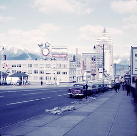
Looking north from Bowell-McLean Motor Co. Ltd. at 615 Burrard Street
![Bldgs. [Buildings on the north side of the 600 block of Hastings St.]](/uploads/r/null/6/4/64b973f3b3c9cb2b4aacf7687a576bcdb575fe8a8d0778960483abc44eac347c/96dcae5c-a1ef-4954-9ed8-36549a7fa8f8-A21867_142.jpg)
Bldgs. [Buildings on the north side of the 600 block of Hastings St.]
![[The Eaton's of Canada float in the 600 Block of Granville Street in the Grey Cup Parade]](/uploads/r/null/7/9/79d132f120bd23aff7dae0ecb1f23471bab3aa83f6a24a5fea35064279445606/1fe078a1-8dfd-4fbf-9c80-478749eab632-A61194_142.jpg)
[The Eaton's of Canada float in the 600 Block of Granville Street in the Grey Cup Parade]
600 block of Granville Street
![[View of 100 block West Cordova Street, south side, looking east]](/uploads/r/null/0/d/4/0d42b77e9d578c3c8554b3640a7d3f27a72839fab0ec6e4eb805d16de90285b8/abd54da6-9198-4386-9052-c77e37baf43d-CVA480-332_142.jpg)
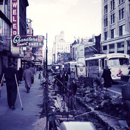
[View of 100 block West Cordova Street, south side, looking east]

Hastings and Vernon Dr.
[Exterior of the Imperial Bank of Canada (formerly Bank of Montreal) on the northeast corner of Granville Street and Dunsmuir Street]
![Bank of Commerce Hastings and Hamilton [Streets]](/uploads/r/null/c/f/cf874cf3b2915734b221c4d0203386cbb04ac0be490101394f410352919c3a7b/b92ac7da-fc6d-4a66-8779-8ad7cc01928e-A21872_142.jpg)
Bank of Commerce Hastings and Hamilton [Streets]
![Imperial Bank [of Canada - 586 Granville St.]](/uploads/r/null/6/d/6d29e7155e220086ee27fd26ceae98ea1110c77b0f1b3ae08df45462b70261b9/6cfa10b2-0b8e-4bd5-9fc4-94f1d7a49a1a-A21871_142.jpg)
Imperial Bank [of Canada - 586 Granville St.]
![[Fairmont Road washed out after the storm]](/uploads/r/null/f/d/fdac97656d097c1db744ea7ebff607ce140d236c2c466c08c6de0f6317783415/616b630a-7f25-40f6-9722-b0b838b2a7aa-A33735_142.jpg)
[Fairmont Road washed out after the storm]

Intersection at West Hastings and Burrard Streets
![Granville [Street] and Georgia [Street] looking north](/uploads/r/null/7/a/7a8f8d400666761c78aa31d135b120372695fb96e6be2e0d510d5272524258bb/75bbeab0-adb5-4c2d-b9ed-db368bc59dad-A44929_142.jpg)
Granville [Street] and Georgia [Street] looking north

Visitors map of Vancouver ; world famous Stanley Park ; downtown Vancouver

Street map of Vancouver
![Looking east on Hastings [Street] from Howe [Street]](/uploads/r/null/e/a/ea05aa39c0a46ee21345d98715647bb2bf402993c2372614cb432f6f412c69fa/94567666-7917-46cd-ab03-909b4d48e8ca-A49843_142.jpg)
Looking east on Hastings [Street] from Howe [Street]
![Commercial Dr. [1100 block]](/uploads/r/null/a/6/a6812284557e58d94a65780c0ea1dfe43d4e6d9800bc40420c39894a17a4e120/ff274150-6cf1-4cba-aa50-993a2b5529f4-A21864_142.jpg)
Commercial Dr. [1100 block]
![[Granville St. at Hastings St., looking south]](/uploads/r/null/3/f/3f5c9c270d59846d9552f5e5c9c93dd128d30ad0698afa539c75b12d1c38afc0/93642b9d-f977-478f-9940-f53ece9cdca0-A43717_142.jpg)
[Granville St. at Hastings St., looking south]

Visitors map of Vancouver
![Commercial Dr. [and Napier Street]](/uploads/r/null/d/d/dd78f6946be88c111510b4b9c592029fe585d9eebe78a05eb707be8f5d27a525/5e0f7c01-038b-4d82-8fde-57092224de9e-A21865_142.jpg)
Commercial Dr. [and Napier Street]
![Commercial Drive a[t] 2nd Ave](/uploads/r/null/c/1/c11d20207674653e27261ccee1a0049c388d60ff0e39ac00e2be3db2906ae3c2/75a17f2f-80e3-4991-8f72-b049746747b4-A21866_142.jpg)
Commercial Drive a[t] 2nd Ave

[View of the new Post Office construction site looking towards Georgia between Hamilton and Homer Streets]

Sheet S.V. 17 : Jellicoe Street to Boundary Road and Sixty-third Avenue to Fraser River

Sheet S.V. 16 : Dawson Street to Boundary Road and Fiftieth Avenue to Sixty-third Avenue

C.P.R. Station at 601 West Cordova Street

Dial map of Greater Vancouver and suburbs

Map of Fraser Valley ; Street map of New Westminster ; Map of Greater Vancouver transit lines

False Creek development survey occupation plan
![[One way traffic Seymour St. at Georgia Street, looking south]](/uploads/r/null/6/a/6ab5722dd80ce8659c50534737b97713ef7378106e8777583f6504275d6eb353/28fb7cc1-f428-4efb-9354-3631dfad7020-A43714_142.jpg)
[One way traffic Seymour St. at Georgia Street, looking south]
![[View of the last Vancouver Lulu Island inter urban tram near 41st Avenue and West Boulevard]](/uploads/r/null/c/7/c715e285bdfbbf1452f4d508f757efdd5a46b36dd8ebd2541123720536fe6b23/85e878f3-5c22-4418-858a-9f02c76bdd3f-A25954_142.jpg)
[View of the last Vancouver Lulu Island inter urban tram near 41st Avenue and West Boulevard]
![[View of Cambie Street looking north from 49th Avenue]](/uploads/r/null/3/6/368e2de9261040b224898e9148ce0871a48d75a4d666f076fd9d75ef7226b951/1fcc0dd8-fa94-452a-91a9-555cc0174f23-A10280_142.jpg)
[View of Cambie Street looking north from 49th Avenue]
![[Northern view of East and West Boulevards from 41st Avenue]](/uploads/r/null/3/2/3286ca497b6ee711846e2170fe1ac12ecf59f59cffdd2b6f258a38607eeab617/0a3e79e1-c927-4059-9d19-3bf26fed9ad2-A25960_142.jpg)
[Northern view of East and West Boulevards from 41st Avenue]

Part of Business Section, Gibsons, B.C.

Map of Fraser Valley

Dial map of Greater Vancouver
![[Eastern view of 41st Avenue from East Boulevard]](/uploads/r/null/1/2/122c5971e183c9022cb9c0a3497f4d988373af58c89d857373c36e1410167faa/a4f74b60-6415-473b-8bb9-f791327e8a8e-A25961_142.jpg)
[Eastern view of 41st Avenue from East Boulevard]
![[Looking west on 41st Avenue from Maple Street]](/uploads/r/null/8/7/87f1081cf37bab5ae5e0e7c862f01cb7b344015c41740a48283df8d5572f518a/ca978dbe-23e2-4048-a79a-89ca4333c950-A25956_142.jpg)
[Looking west on 41st Avenue from Maple Street]
![[View of the first trolley bus in Kerrisdale at 41st Avenue and West Bouleverd]](/uploads/r/null/6/3/63a304dfd9591cc536701117321431f2b56e221ffcdd6686ecf9d94364c6b0ef/8630df3d-84ec-44aa-8cd7-dcc1e7ca9ca2-A25953_142.jpg)
[View of the first trolley bus in Kerrisdale at 41st Avenue and West Bouleverd]
![[Granville St. at Hastings St., looking south]](/uploads/r/null/a/2/a286ad43424d24fba08f581e54a465eeb391f36eb29ace65d92f0af5cb37c0f9/0b5bae2a-805d-4102-841b-ed894e819156-A43718_142.jpg)
[Granville St. at Hastings St., looking south]
![[View of Hastings Street looking west from Richards Street]](/uploads/r/null/0/1/012d9664d1474850ebc9e142ecf3f3ffd4bf50cde6134eb7be334d3762a5f7f7/1685247a-d5d0-4613-9d88-1104852faad4-A37231_142.jpg)
[View of Hastings Street looking west from Richards Street]
![[View of Cambie Street looking north from 45th Avenue]](/uploads/r/null/a/3/a300230d1538c4f855920a7835f1a5a079457965c7f96f0f366d818d06aab81d/05e20915-bf9c-49c4-8d3a-7120e6be17e1-A10278_142.jpg)
[View of Cambie Street looking north from 45th Avenue]
![[View of Cambie Street looking south from 41st Avenue]](/uploads/r/null/e/6/e67a5a2e77af574a261d54ff12e9b09998caa75945658582aec7399d6491335a/e0e01dc3-8422-4b5f-855c-78b2c312bcce-A10276_142.jpg)
[View of Cambie Street looking south from 41st Avenue]
![[View of Cambie Street looking south from 41st Avenue]](/uploads/r/null/b/3/b37c0397b99f41e571e2a73b5a0d2b5b208f3e67606a809d1ab2b4fd92e11fb7/816ee128-3b41-4917-a160-974e85d3a05c-A10277_142.jpg)
[View of Cambie Street looking south from 41st Avenue]
![[Granville St. at Hastings St., looking south]](/uploads/r/null/a/2/a2b150fdc2d0d1091b88dcb4036e315291c2712f91faf805ab8ed329a1a56990/cd90450d-d6b2-45e1-8810-c58b313df506-A43716_142.jpg)
[Granville St. at Hastings St., looking south]