![[A parade celebrating VJ Day on Pender Street]](/uploads/r/null/6/9/5/6950ec243113934ac6ba2b533ebb6ee37a932787e8bfdc1ce53afe22fc60297d/e0189c62-fd54-4b9a-9b3b-cb2487f6373b-CVA260-1413_142.jpg)
[A parade celebrating VJ Day on Pender Street]
- AM640-S1-: CVA 260-1413
- Item
- 1945
Part of James Crookall fonds
Photograph shows a woman holding a copy of the Vancouver Sun with the headline "Official Peace"
[A parade celebrating VJ Day on Pender Street]
Part of James Crookall fonds
Photograph shows a woman holding a copy of the Vancouver Sun with the headline "Official Peace"
![[A parade celebrating VJ Day on Pender Street]](/uploads/r/null/d/2/c/d2c624cbb295abd99dfcbce8c9a1d74acfe126849e3a820934416699ae942dfe/f70c97f4-1855-4fbd-9fae-db43dc0444e9-CVA260-1412_142.jpg)
[A parade celebrating VJ Day on Pender Street]
Part of James Crookall fonds
![[View along Hastings Street]](/uploads/r/null/a/f/0/af0c2d7a1243caf3246da8366e945f29fef1f9aa7a9dce1d1db913b93bbd0619/3714ccec-0814-4cfb-af4c-2cdba1332650-CVA260-1228_142.jpg)
Part of James Crookall fonds
![[Unidentified city street]](/uploads/r/null/7/c/e/7ceb45b8354618d0f0059f694c9a1c81bb57e939029183cf189a18af718ac736/57b8027d-00ac-4ac6-bebb-8337fc82535b-CVA260-1127_142.jpg)
Part of James Crookall fonds
![[View of Lower Broadway, New York City]](/uploads/r/null/8/8/5/885cb0bb690bb61a0fa15423c4cc2399f2c6f583a04a2070d765308d1d33512a/6d26f662-87bf-4151-8c37-697d43ebf72e-CVA260-1117_142.jpg)
[View of Lower Broadway, New York City]
Part of James Crookall fonds
Item is a photograph showing Stevens House, Aldrich Court at 41-45 Broadway.
![[Street in New York City]](/uploads/r/null/c/b/e/cbe23ee2ebee63aa65b3f1ce0b2658f1e1fd0f6c67136e55193880c74850bd29/02f49c3d-0d40-4037-9c16-dfef02cd9bb2-CVA260-1107_142.jpg)
Part of James Crookall fonds
![[Pedestrians in the 700 Block of Granville Street]](/uploads/r/null/2/5/255f492d6cee3822854c8b9219474a9a3922e77c6a294d4a2218a76b039a523a/e26503a8-f659-4fc5-80af-d88404ecbad2-A44930_142.jpg)
[Pedestrians in the 700 Block of Granville Street]
Part of Greater Vancouver Visitors and Convention Bureau fonds
Photograph shows Sheppard Shoes and a sign for The Office Piano Bar and Lounge
Part of Major Matthews collection
Photograph shows a view looking west along Alexander Street
![[Entrance to Whytecliffe Park on Marine Drive above Batchelor Bay]](/uploads/r/null/c/4/c441051a7d56e18d0d5e15b8696b185d65a619fea84eaa7021777b04e5da5bc5/14fe946c-2293-4553-864f-03a99cbc9c66-A09901_142.jpg)
[Entrance to Whytecliffe Park on Marine Drive above Batchelor Bay]
Part of Major Matthews collection
![[Marine Drive near West Bay showing Point Atkinson in the distance]](/uploads/r/null/4/d/4df8d326019887f7b39ac7982fc4dc46b806c358ed8a8f52e62af5d7278d1e68/ef580852-d5ba-49ad-b37e-63a37949bb9b-A09899_142.jpg)
[Marine Drive near West Bay showing Point Atkinson in the distance]
Part of Major Matthews collection
![[Looking northeast from Georgia Street from the Hotel Vancouver]](/uploads/r/null/2/e/2e30a81e66603255723d799e9f1215adb293b70ba08c2bf260e26382e4877c46/3ba8e365-b9d3-4fb8-b8ad-35b511bc12b5-A43260_142.jpg)
[Looking northeast from Georgia Street from the Hotel Vancouver]
Part of Major Matthews collection
Photograph shows the east side of the 600 Block Granville Street including the Hudson Bay Company store, the New York Block and the excavation for the new Hudson Bay store
![[Looking northeast from Georgia Street from the Hotel Vancouver]](/uploads/r/null/6/3/63e4cb0982036a6ffb3d269b9757505dd2fd130896c126d0290164c76587e71d/72199e95-347b-404a-98c9-a6727a7f6ccd-A43257_142.jpg)
[Looking northeast from Georgia Street from the Hotel Vancouver]
Part of Major Matthews collection
Photograph shows the east side of the 600 Block Granville Street including the Hudson Bay Company store and the New York Block
![[Looking north from Georgia Street from the Hotel Vancouver]](/uploads/r/null/9/7/97e0cda9e3e6069a38aab5983c020f2d954c7c8d3df3707c37d19bfaefc1ed85/3f1b120e-1142-4754-96b3-399a240e2ec0-A43256_142.jpg)
[Looking north from Georgia Street from the Hotel Vancouver]
Part of Major Matthews collection
Photograph shows the 600 Block between Howe Street and Granville Street including part of the C.P.R. Park, the Van Horne Building and the Bank of Montreal
![[Looking northwest from Georgia Street from the roof of the Hotel Vancouver]](/uploads/r/null/3/e/3e78aa7a1d4d4210fdc17d391ece8c1437fc6e68115de6b0aa6c30506f2a7d4e/fd620b58-87ca-473a-a4c8-17218eb63664-A43255_142.jpg)
[Looking northwest from Georgia Street from the roof of the Hotel Vancouver]
Part of Major Matthews collection
Photograph shows the west side of the 600 Block of Howe Street including Manor House and Brockton Point in the background
![[Looking north from Georgia Street from the Hotel Vancouver]](/uploads/r/null/e/d/ed4c233f2e1cd9eee56c7b04ac27b10decea1348908ebee9b4f38674e25aa5d9/ae2582ab-d8dc-477a-9e94-63eab8f9d55e-A25788_142.jpg)
[Looking north from Georgia Street from the Hotel Vancouver]
Part of Major Matthews collection
Photograph shows the 600 Block between Howe Street and Granville Street including The Van Horne Building and the Bank of Montreal
Part of Major Matthews collection
Photograph shows the west side of the 600 Block of Howe Street including Manor House
![[Looking west along Georgia Street at Howe Street from the roof of the second Hotel Vancouver]](/uploads/r/null/e/a/eaf470ff6789cc2b12ce452e09b469421aa6854a8793f4caef7b539b19c66e58/dc88c4dd-55eb-431c-9db6-31525dadd68c-A25786_142.jpg)
[Looking west along Georgia Street at Howe Street from the roof of the second Hotel Vancouver]
Part of Major Matthews collection
Photograph shows Walker and Robinson Nursery and Christ Church Cathedral
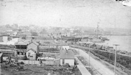
![[Northern view of Westminster Avenue (Main Street) from 7th Avenue]](/uploads/r/null/e/e/eedf5dc6b5cf6caafadff512ec18cf952b58c3fe76cbe821bad2890dd36af4ad/ead53220-dc8f-4f5e-9654-b6cea29e57c4-A43237_142.jpg)
[Northern view of Westminster Avenue (Main Street) from 7th Avenue]
Part of Major Matthews collection
Photograph shows the Westminster Avenue Trestle Bridge and False Creek in the background

Looking Across the Inlet from Hotel Vancouver
Part of Major Matthews collection
Photograph shows a view looking north from Georgia Street showing the west side of the 600 Block Howe Street including Manor House and beyond to Deadman's Island

Part of Vancouver, B.C. from Hotel Vancouver
Part of Major Matthews collection
Photograph shows part of the east side of the 600 block of Granville Street including the Hudson's Bay Company store, the New York Block and the Van Horne Block

Part of Vancouver, B.C. from Hotel Vancouver
Part of Major Matthews collection
Photograph shows the east side of the 600 Block of Granville Street including the New York Block and a liquor store and beyond to the Homer Street Methodist Church, the tower of Holy Rosary Cathedral and houses
![[View looking north from the Hotel Vancouver]](/uploads/r/null/9/9/99eaf089c09cb55adebf58a48da630b579acf4ad6f082c248fb97e9c183a2dd9/40e47503-495b-458b-a5c2-bbee86d95a90-A43204_142.jpg)
[View looking north from the Hotel Vancouver]
Part of Major Matthews collection
Photograph shows the area north of Georgia Street between Howe Street and Granville Street including the C.P.R. Park, The Van Horne Block, the Bank of Montreal and other buildings
![[Looking east along Hastings Street from Richards Street]](/uploads/r/null/e/4/e404cb003d8e816d1c249f79b35871dd5cc9d3bc2bc0dd7d45bb80e4df55dc52/8f9669b5-1cf9-45f9-bfc2-7601733fbc64-A43220_142.jpg)
[Looking east along Hastings Street from Richards Street]
Part of Major Matthews collection
Panoramic view from the Lefevre Block showing the Innes-Thompson (Innes-Townley) Block, The A.G. Ferguson Block, the Bank of British Columbia, the News-Advertiser and other buildings and streetcars
![[Looking east from Cambie Street between Cordova Street and Hastings Street]](/uploads/r/null/d/5/d524980ab64d0ea74e90d8e468434bc26a72344b4a340d635be3e0ed8bff4741/fabf27da-674f-45e5-ba45-be0974cd441c-A43217_142.jpg)
[Looking east from Cambie Street between Cordova Street and Hastings Street]
Part of Major Matthews collection

Part of Vancouver, B.C. from Hotel Vancouver
Part of Major Matthews collection
Photograph shows a view looking north across Burrard Inlet from Granville Street and Georgia Street including the Van Horne Block and the Hudson Bay Company Store
![[View of Georgia Street looking west from Howe Street]](/uploads/r/null/7/2/720449fb41b44ff96e68a6a510f5c5a4b8dd5e1804b942aad42d7c3cfeda7681/4a70432e-a803-4411-86cd-f2c631add065-A43216_142.jpg)
[View of Georgia Street looking west from Howe Street]
Part of Major Matthews collection
Photograph shows Christ Church Cathedral and Stanley Park in the background
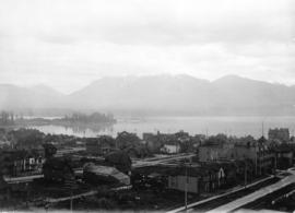
Vancouver, B.C. from the South
Part of Major Matthews collection
Photograph shows a view looking north from the corner of Westminster Avenue (Main Street) and 7th Avenue including the Westminster Avenue Trestle Bridge and False Creek in the background
Part of Major Matthews collection
Photograph shows a northern view of Mount Pleasant and False Creek from Westminster Avenue (Main Street) and 7th Avenue and a streetcar
![[Looking northwest from the Hotel Vancouver on the corner of Granville Street and Georgia Street]](/uploads/r/null/9/b/9bc7b31467f04c66440a23b6ad44d02934b3756b8e0dda107f815f6656f91e37/d52fede5-4254-4096-aaba-a44a1b3957c5-A43212_142.jpg)
[Looking northwest from the Hotel Vancouver on the corner of Granville Street and Georgia Street]
Part of Major Matthews collection
Photograph shows a view of the west side of the 600 Block Howe Street and beyond

Vancouver, B.C. from Hotel Vancouver
Part of Major Matthews collection
Photograph shows a view looking east from Georgia Street towards the 600 Block Seymour Street
![[View looking north from City Hall]](/uploads/r/null/3/7/3719510f814648ae0b2e7b0ce76d43a412104e50f0c080895fe1c0a328907de6/96db8e82-b144-4bfe-9fe2-c74239a3f26b-A43298_142.jpg)
[View looking north from City Hall]
Part of Major Matthews collection
Photograph shows the Fraser Valley Milk Producers Association (Dairyland) building, the Cambie Bridge, False Creek, Downtown anf The Lions in the background

Part of Major Matthews collection
Photograph shows a view looking north from the corner of Westminster Avenue (Main Street) and 7th Avenue including the Westminster Avenue Trestle Bridge and False Creek in the background
![[Panoramic view looking north from the Hotel Vancouver]](/uploads/r/null/d/0/3/d032ae1a08ec1b68763941336f6a07708bf678235ae8cdf506cbbdc3fb10451d/98ea51ff-abce-48a9-9401-16834b8ba6a4-VanScP143_142.jpg)
[Panoramic view looking north from the Hotel Vancouver]
Part of Major Matthews collection
Photographs show the west side of the 600 Block of Howe Street, Manor House, Deadman's Island, the 600 Block of Granville Street, the Van Horne Block, the Hudson Bay Company store, the Homer Street Methodist Church, the tower of Holy Rosary Cathedral and other buildings and houses
![[View looking north from City Hall]](/uploads/r/null/7/a/7a5cefae760823892740b59c0b38bbc5bd3272ce46ad037b620199ee82e0416c/eef32f5c-231c-4970-8973-c3324d2a90d1-A43290_142.jpg)
[View looking north from City Hall]
Part of Major Matthews collection
Photograph shows the Fraser Valley Milk Producers Association (Dairyland) building, the Cambie Bridge, False Creek and Downtown in the background
![[View of the east side of the 600 Block Granville Street]](/uploads/r/null/7/0/701ea9e113109a11728915c53b9320ccd9c10a7cb13f66dcbd9f863af09eabb4/358794d9-e088-422e-ad90-962c67e5f1a9-A43289_142.jpg)
[View of the east side of the 600 Block Granville Street]
Part of Major Matthews collection

Georgia Street Vancouver, B.C.
Part of Major Matthews collection
Oblique view looking east along Georgia Street from Broughton Street showing the Felix Apartments on Jervis Street, The Hotel Vancouver, Christ Church Cathedral and other buldings
![[Western view of Fairview from the tower of King Edward High School on 12th Avenue and Oak Street]](/uploads/r/null/5/7/57f78634c36cdc44896b928e95b888dc11481e391bcf511d52692a2ee6953e09/d4c21e48-ce87-44ed-8181-22199bd4fa93-A43281_142.jpg)
[Western view of Fairview from the tower of King Edward High School on 12th Avenue and Oak Street]
Part of Major Matthews collection
Photograph shows the C.P.R. Kitsilano Trestle and the Granville Street Bridges

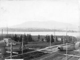
Portion of Vancouver, B.C. Looking Northeast
Part of Major Matthews collection
Photograph shows a view from the Hotel Vancouver showing part of the B.B. Johnson (Johnson and Howe) Block and the east side of the 600 Block of Granville Street including the New York Block and the Bank of Montreal

Vancouver, B.C. from Hotel Vancouver
Part of Major Matthews collection
Photograph shows the 600 Block between Howe Street and Granville Street including part of the C.P.R. Park, the Van Horne Building and Manor House
![[Looking northeast from Georgia Street from the Hotel Vancouver]](/uploads/r/null/8/a/8a3cf4ec45565ce8c42c5be70e3dc9bba77700670833bbf6543e337be1a6b54e/111407b8-0df6-4047-899b-7bcaf3802d1e-A43264_142.jpg)
[Looking northeast from Georgia Street from the Hotel Vancouver]
Part of Major Matthews collection
Photograph shows the east side of the 600 Block of Granville Street and beyond including the New York Block, the Simpson Block, the Crew Block, Homer Street Methodist Church, St. Anne's Academy and Holy Rosary Church (before the steeple was built)
![[Looking north from Georgia Street from the Hotel Vancouver]](/uploads/r/null/0/6/068fe03d8f45f3fc51aa86d37db6e46b2d340ec131401540ce8820b4a53f3e9a/fcf47eba-f8dc-43a3-ab61-1a71338fe9d8-A43263_142.jpg)
[Looking north from Georgia Street from the Hotel Vancouver]
Part of Major Matthews collection
Photograph shows the 500 and 600 Blocks of between Howe Street and Granville Street including part of the C.P.R. Park, the Japanese Consul, Manor House under construction, the Van Horne Block and the Bluff showing the homes of A.G. Ferguson and Harry Abbott in the background

Vancouver, as seen from Hotel Vancouver
Part of Major Matthews collection
Photograph shows the buildings under construction on the east side of the 600 Block of Granville Street including the New York Block
![[Inspection of 6th Regiment D.C.O.R. on Cambie Street grounds]](/uploads/r/null/2/e/2ef9009e1370d881168d5b9564a0b91823a5cd05e51b96a18f4d25d756105e43/8584938e-bbc7-4c8e-a54e-d62d04d8f8bc-A26733_142.jpg)
[Inspection of 6th Regiment D.C.O.R. on Cambie Street grounds]
Part of Major Matthews collection
Photograph shows the houses in the 600 block on the west side of Cambie Street and the spires of the St. Andrews Presbyterian Church and Holy Rosary Cathedral
![[Aerial view of Mount Pleasant, South Strathcona and Kensington-Cedar Cottage]](/uploads/r/null/7/5/75ea991fe8319eaffda79b314cbf20e281e35eb2cd8a89eaa898b492242d6282/05f856f3-0a45-41eb-94dc-46cb9d2f7ecf-A63348_142.jpg)
[Aerial view of Mount Pleasant, South Strathcona and Kensington-Cedar Cottage]
Part of Major Matthews collection
Photograph shows aerial view of the east end of False Creek, Thornton Park, Great Northern Railway and Canadian National Railway yards, Mount Pleasant, Strathcona, Grandview-Woodland, Trout Lake, Kingsway, Vancouver Technical School grounds, Renfrew playing fields, John Hendry Park, British Columbia Electric Railway Right of Way, Clark Park, Grandview Highway South, Great Northern Railway.
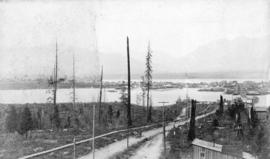
![[Streetcar line construction on Powell Street looking west from Westminster Avenue (Main Street)]](/uploads/r/null/d/8/d8884536bf5d76c43435e3bd2e7aff38b879a22cfe27532fd0b24b7c5482ac4a/cad8152b-7719-4bcc-973d-a082d6e82242-A37512_142.jpg)
[Streetcar line construction on Powell Street looking west from Westminster Avenue (Main Street)]
Part of Major Matthews collection
Photograph shows part of the first City Hall on the far right
![[Streetcar line construction on Westminster Avenue (Main Street)]](/uploads/r/null/2/e/2e11f1b88aede4c0a2ce506bae1ec7c0a9a7fee2726e6e29c6c23f0c6b448cb1/e5f93bcf-7245-4739-999d-c179ae971e63-A37511_142.jpg)
[Streetcar line construction on Westminster Avenue (Main Street)]
Part of Major Matthews collection
Photograph shows a view looking north from near Prior Street
![[Streetcar line construction on Westminster Avenue (Main Street)]](/uploads/r/null/c/d/cd6ae92c940a945bf869cecbbd6cfc810a1c0b210fb431de7ab96c3a0f746f48/2485f482-524d-4662-b9df-0eae6874feac-A37510_142.jpg)
[Streetcar line construction on Westminster Avenue (Main Street)]
Part of Major Matthews collection
Photograph shows a view looking north from near Prior Street
![[Granville Street looking south]](/uploads/r/null/1/9/19fce682b0720f24b0d0558802a92dcc7ed4b269190a237ee607388a4899642c/319489f2-e160-415f-b0a9-18dc53e07e01-A37478_142.jpg)
[Granville Street looking south]
Part of Major Matthews collection
![[Granville Street looking north]](/uploads/r/null/c/b/cb1f9194e0eedd66fc1b128f35e3b13e1fb435f5ac8ef246f08d4470933b38a2/b8314769-3706-451e-83da-76878e4a012f-A37477_142.jpg)
[Granville Street looking north]
Part of Major Matthews collection
![[1940 Seattle trolley bus built by Twin Coach on demonstration for the Cleveland Railway Company]](/uploads/r/null/4/2/42911f50ffda9bdc842491252a090a83bf8e286952608b21c76784b2892c3b77/5eed8c2d-16bf-4432-bbeb-1dceaf8fbf37-A37556_142.jpg)
[1940 Seattle trolley bus built by Twin Coach on demonstration for the Cleveland Railway Company]
Part of Major Matthews collection
Photograph shows the old Federal Building