![Seymour and Robson [Streets looking] east](/uploads/r/null/8/9/8907daf6376f3ca1054710a93f7570ad24545f01a233cec012bf99b566ab98ba/eaa2f8c0-bc68-4c2c-8084-5271983fc6e4-A44339_142.jpg)
Seymour and Robson [Streets looking] east
- COV-S505-1-: CVA 772-1348
- Item
- [between 1980 and 1997]
Part of City of Vancouver fonds
5918 results with digital objects Show results with digital objects
Seymour and Robson [Streets looking] east
Part of City of Vancouver fonds
![Seymour and Robson [Streets looking] north](/uploads/r/null/8/1/8126e6756fcab4331908a051afa25cce43dc8e9f72b8cb53060d14752787774f/9d722eff-83bd-4cff-ba15-a9a0796bd78f-A44338_142.jpg)
Seymour and Robson [Streets looking] north
Part of City of Vancouver fonds
![Seymour and Robson [Streets looking] south](/uploads/r/null/7/2/72cf8ff47d98a23e19034180b1685bfc5f3eb2ebe671d50f108c5fe5db2d5498/464ea997-8487-499a-8db1-44f68ab32b6f-A44340_142.jpg)
Seymour and Robson [Streets looking] south
Part of City of Vancouver fonds
![Seymour and Robson [Streets looking] west](/uploads/r/null/b/3/b3ef02fdb988a534cb4c772aa8375289c58cc8148cfc43b5e762076bb8c675b8/f2027a95-d7bc-413b-867b-4fc343c07717-A44341_142.jpg)
Seymour and Robson [Streets looking] west
Part of City of Vancouver fonds
![Seymour and Smithe [Streets looking] east](/uploads/r/null/7/f/7f8c39882970ba8bd4b1b4e609b2e3bd370f4c7faabb2d28ed62eca7eff87325/8a305f46-868c-4c94-abd4-8cc3e9beb387-A44345_142.jpg)
Seymour and Smithe [Streets looking] east
Part of City of Vancouver fonds
Photograph shows a part the Dufferin Hotel
![Seymour and Smithe [Streets looking] north](/uploads/r/null/e/6/e6bf4f17985372ec3367379b9384cce83febed96caa780642af80ba1d0a87552/cbf65406-0097-4bbf-a0f3-fbd90bae2538-A44344_142.jpg)
Seymour and Smithe [Streets looking] north
Part of City of Vancouver fonds
![Seymour and Smithe [Streets looking] south](/uploads/r/null/d/5/d5bcc27b3757087b3b92f191da70d0615a29bfcc278359a7c377c6e8a2fbb9a0/92a1a469-460c-48cb-ad72-9f27aff49a33-A44343_142.jpg)
Seymour and Smithe [Streets looking] south
Part of City of Vancouver fonds
Photograph shows the Dufferin Hotel
![Seymour and Smithe [Streets looking] west](/uploads/r/null/f/3/f3af716c31fd67dde6617cd3ddc945b73944f70c86b04947f2cfda0d2120104c/f364836b-c734-4c6d-8caf-c1c2bf7f4faf-A44342_142.jpg)
Seymour and Smithe [Streets looking] west
Part of City of Vancouver fonds
![[Seymour St. at Nelson St., looking east]](/uploads/r/null/6/7/674f17e26621bf88a01685886f3b90e9c81d8d4f7631a2430e620005b18466ff/7df56426-d3dd-4bfd-a460-566da7150ef1-A43720_142.jpg)
[Seymour St. at Nelson St., looking east]
Part of City of Vancouver fonds
Photograph shows Seymour Billiards.
![[Seymour St. at Nelson St., looking south]](/uploads/r/null/8/d/8d69424c601584cffb333ab74e4d1b3c00f1b2bd937c1bea590a1a4aa47e4a0c/0a8db746-af90-4c3c-9a76-617c2433e7cf-A43719_142.jpg)
[Seymour St. at Nelson St., looking south]
Part of City of Vancouver fonds
Photograph shows a portion of the Seymour Billiards sign, the Hotel Duffrin, Vancouver Ford Centre Motors and Dominion Motors.

This postcard includes personal correspondence addressed to Mrs. Harrison of Montreal.
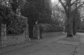
Shaughnessy Street landscaping
Part of City of Vancouver fonds
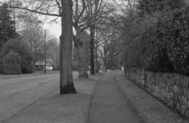
Shaughnessy Street landscaping
Part of City of Vancouver fonds

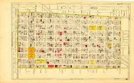
Sheet 1 : Cambie Street to Carolina Street and Sixteenth Avenue to Twenty-eighth Avenue
Part of City of Vancouver Archives technical and cartographic drawing collection
Item is a section showing the area from Cambie Street to Carolina Street and Sixteenth Avenue to Twenty-eighth Avenue. Includes streets, roads, blocks, lots, legal descriptions, parks, nurseries and schools.
Vancouver (B.C.). Office of the City Engineer

Sheet 1 : Cambie Street to Carolina Street and Sixteenth Avenue to Twenty-eighth Avenue
Part of City of Vancouver fonds
Item is a section showing the area from Cambie Street to Carolina Street and Sixteenth Avenue to Twenty-eighth Avenue. Includes streets, roads, blocks, lots, legal descriptions, parks, nurseries and schools. Map is hand coloured to show tax sale property for sale, property with no water, street widening and drainage, replotting, reserved land for schools, reserved land for parks, sundry land, capital assets not including schools and parks, schools, and parks, as applicable.
Vancouver (B.C.). Office of the City Engineer

Sheet 1 : Slocan Street to Boundary Road and Triumph Street to Burrard Inlet
Part of City of Vancouver Archives technical and cartographic drawing collection
Item is a section showing the area bound by Slocan Street, Boundary Road, Triumph Street and the waterfront. Includes streets, roads, railways, blocks, lots, legal descriptions, quit claims, leases, parks and businesses along the waterfront.
Vancouver (B.C.). Office of the City Engineer

Sheet 1 : Slocan Street to Boundary Road and Triumph Street to Burrard Inlet
Part of City of Vancouver fonds
Item is a section showing the area bound by Slocan Street, Boundary Road, Triumph Street and the waterfront. Includes streets, roads, railways, blocks, lots, legal descriptions, quit claims, leases, parks and businesses along the waterfront. Section is annotated in colour to show tax sale property for sale, property with no water, street widening and drainage, replotting, reserved land for schools, reserved land for parks, sundry land, capital assets not including schools and parks, schools, and parks, as applicable.
Vancouver (B.C.). Office of the City Engineer

Sheet 1: Slocan Street to Boundary Road and Triumph Street to Burrard Inlet
Part of City of Vancouver Archives technical and cartographic drawing collection
Item is a section showing the area bound by Slocan Street, Boundary Road, Triumph Street and the waterfront. Includes streets, roads, railways, blocks, lots, legal descriptions, quit claims, leases, parks and businesses along the waterfront.
Vancouver (B.C.). Office of the City Engineer

Sheet 10 : Carlton Street to Boundary Road and Fortieth Avenue to Fiftieth Avenue
Part of City of Vancouver Archives technical and cartographic drawing collection
Item is a section showing the area from Carlton Street to Boundary Road and Fortieth Avenue to Fiftieth Avenue. Includes streets, roads, blocks, lots, legal descriptions, parks and schools.
Vancouver (B.C.). Office of the City Engineer

Sheet 10 : Clark Drive to Slocan Street and Burrard Inlet to Triumph Street
Part of City of Vancouver fonds
Item is a section showing the area from Clark Drive to Slocan Street and aterfront to Triumph Street. Includes streets and roads, blocks, lots, legal descriptions, railways, parks, boys' detention home and businesses along the waterfront. The Town of Hastings is indicated on the map. Map is hand coloured to show tax sale property for sale, property with no water, street widening and drainage, replotting, reserved land for schools, reserved land for parks, sundry land, capital assets not including schools and parks, schools, and parks, as applicable.
Vancouver (B.C.). Office of the City Engineer

Sheet 10 : Clark Drive to Slocan Street and waterfront to Triumph Street
Part of City of Vancouver Archives technical and cartographic drawing collection
Item is a section showing the area from Clark Drive to Slocan Street and aterfront to Triumph Street. Includes streets and roads, blocks, lots, legal descriptions, railways, parks, boys' detention home and businesses along the waterfront. The Town of Hastings is indicated on the map.
Vancouver (B.C.). Office of the City Engineer

Sheet 10 : Clark Drive to Slocan Street and waterfront to Triumph Street
Part of City of Vancouver Archives technical and cartographic drawing collection
Item is a section showing the area from Clark Drive to Slocan Street and waterfront to Triumph Street. Includes streets and roads, blocks, lots, legal descriptions, railways, parks, boys' detention home and businesses along the waterfront. The Town of Hastings is indicated on the map.
Vancouver (B.C.). Office of the City Engineer

Sheet 10 : Earles Street to Boundary Road and Fortieth Avenue to Fiftieth Avenue
Part of City of Vancouver fonds
Item is a section showing the area from Carlton Street to Boundary Road and Fortieth Avenue to Fiftieth Avenue. Includes streets, roads, blocks, lots, legal descriptions, parks and schools. Map is hand coloured to show tax sale property for sale, property with no water, street widening and drainage, replotting, reserved land for schools, reserved land for parks, sundry land, capital assets not including schools and parks, schools, and parks, as applicable.
Vancouver (B.C.). Office of the City Engineer

Sheet 11 : Cambie Street to St. George Street and Forty-seventh Avenue to Fifty-eighth Avenue
Part of City of Vancouver fonds
Item is a section showing the area from Cambie Street to St. George Street and Forty-seventh Avenue to Fifty-eighth Avenue. Includes streets, roads, blocks, lots, legal descriptions, golf courses, parks and schools. Map is hand coloured to show tax sale property for sale, property with no water, street widening and drainage, replotting, reserved land for schools, reserved land for parks, sundry land, capital assets not including schools and parks, schools, and parks, as applicable.
Vancouver (B.C.). Office of the City Engineer

Sheet 11 : Cambie Street to St. George Street and Forty-seventh Avenue to Fifty-eighth Avenue
Part of City of Vancouver Archives technical and cartographic drawing collection
Item is a section showing the area from Cambie Street to St. George Street and Forty-seventh Avenue to Fifty-eighth Avenue. Includes streets, roads, blocks, lots, legal descriptions, golf courses, parks and schools.
Vancouver (B.C.). Office of the City Engineer

Sheet 11 : Carrall Street to Clark Drive and waterfront to Keefer Street
Part of City of Vancouver Archives technical and cartographic drawing collection
Item is a section showing the area from Carrall Street to Clark Drive and waterfront to Keefer Street. Includes streets and roads, blocks, lots, legal descriptions, railways, parks, schools, freight sheds, warehouses, piers and businesses along the waterfront.
Vancouver (B.C.). Office of the City Engineer

Sheet 11 : Carrall Street to Clark Drive and waterfront to Keefer Street
Part of City of Vancouver fonds
Item is a section showing the area from Carrall Street to Clark Drive and waterfront to Keefer Street. Includes streets and roads, blocks, lots, legal descriptions, railways, parks, schools, freight sheds, warehouses, piers and businesses along the waterfront.Map is hand coloured to show tax sale property for sale, property with no water, street widening and drainage, replotting, reserved land for schools, reserved land for parks, sundry land, capital assets not including schools and parks, schools, and parks, as applicable.
Vancouver (B.C.). Office of the City Engineer

Sheet 11 : Carrall Street to Clark Drive and waterfront to Keefer Street
Part of City of Vancouver Archives technical and cartographic drawing collection
Item is a section showing the area from Carrall Street to Clark Drive and waterfront to Keefer Street. Includes streets and roads, blocks, lots, legal descriptions, railways, parks, schools, freight sheds, warehouses, piers and businesses along the waterfront.
Vancouver (B.C.). Office of the City Engineer

Sheet 12 : Prince Edward Street to Bruce Street and Forty-seventh Avenue to Fifty-eighth Avenue
Part of City of Vancouver Archives technical and cartographic drawing collection
Item is a section showing the area from Prince Edward Street to Bruce Street and Forty-seventh Avenue to Fifty-eighth Avenue. Includes streets, roads, blocks, lots, legal descriptions, parks and schools.
Vancouver (B.C.). Office of the City Engineer

Sheet 12 : Prince Edward Street to Bruce Street and Forty-seventh Avenue to Fifty-eighth Avenue
Part of City of Vancouver fonds
Item is a section showing the area from Prince Edward Street to Bruce Street and Forty-seventh Avenue to Fifty-eighth Avenue. Includes streets, roads, blocks, lots, legal descriptions, parks and schools. Map is hand coloured to show tax sale property for sale, property with no water, street widening and drainage, replotting, reserved land for schools, reserved land for parks, sundry land, capital assets not including schools and parks, schools, and parks, as applicable.
Vancouver (B.C.). Office of the City Engineer

Sheet 12 : Ontario Street to Clark Drive and Keefer Street to Second Avenue
Part of City of Vancouver Archives technical and cartographic drawing collection
Item is a section showing the area from Ontario Street to Clark Drive and Keefer Street to Second Avenue. Includes streets, roads, blocks, lots, legal descriptions, railways, parks and schools. Includes Terminal Avenue and land used by the Great Northern Railway and the Canadian National Railway. Annotations in pencil.
Vancouver (B.C.). Office of the City Engineer

Sheet 12 : Ontario Street to Clark Drive and Keefer Street to Second Avenue
Part of City of Vancouver Archives technical and cartographic drawing collection
Item is a section showing the area from Ontario Street to Clark Drive and Keefer Street to Second Avenue. Includes streets, roads, blocks, lots, legal descriptions, railways, parks and schools. Includes Terminal Avenue and land used by the Great Northern Railway and the Canadian National Railway.
Vancouver (B.C.). Office of the City Engineer

Sheet 12 : Ontario Street to Clark Drive and Keefer Street to Second Avenue
Part of City of Vancouver fonds
Item is a section showing the area from Ontario Street to Clark Drive and Keefer Street to Second Avenue. Includes streets, roads, blocks, lots, legal descriptions, railways, parks and schools. Includes Terminal Avenue and land used by the Great Northern Railway and the Canadian National Railway. Map is hand coloured to show tax sale property for sale, property with no water, street widening and drainage, replotting, reserved land for schools, reserved land for parks, sundry land, capital assets not including schools and parks, schools, and parks, as applicable.
Vancouver (B.C.). Office of the City Engineer

Sheet 13 : Fleming Street to Carlton Street and Forty-seventh Avenue to Fifty-ninth Avenue
Part of City of Vancouver fonds
Item is a section showing the area from Fleming Street to Carlton Street and Forty-seventh Avenue to Fifty-ninth Avenue. Includes streets, roads, blocks, lots, legal descriptions, parks and schools. Map is hand coloured to show tax sale property for sale, property with no water, street widening and drainage, replotting, reserved land for schools, reserved land for parks, sundry land, capital assets not including schools and parks, schools, and parks, as applicable.
Vancouver (B.C.). Office of the City Engineer

Sheet 13 : Fleming Street to Carlton Street and Forty-seventh Avenue to Fifty-ninth Avenue
Part of City of Vancouver Archives technical and cartographic drawing collection
Item is a section showing the area from Fleming Street to Carlton Street and Forty-seventh Avenue to Fifty-ninth Avenue. Includes streets, roads, blocks, lots, legal descriptions, parks and schools.
Vancouver (B.C.). Office of the City Engineer

Sheet 13 : Ontario Street to Clark Drive and First Avenue to Sixteenth Avenue
Part of City of Vancouver Archives technical and cartographic drawing collection
Item is a section showing the area from Ontario Street to Clark Drive and First Avenue to Sixteenth Avenue. Includes streets, roads, blocks, lots, legal descriptions, railways, parks and schools. Includes B.C. Electric Railway car barns.
Vancouver (B.C.). Office of the City Engineer

Sheet 13 : Ontario Street to Clark Drive and First Avenue to Sixteenth Avenue
Part of City of Vancouver fonds
Item is a section showing the area from Ontario Street to Clark Drive and First Avenue to Sixteenth Avenue. Includes streets, roads, blocks, lots, legal descriptions, railways, parks and schools. Includes B.C. Electric Railway car barns. Map is hand coloured to show tax sale property for sale, property with no water, street widening and drainage, replotting, reserved land for schools, reserved land for parks, sundry land, capital assets not including schools and parks, schools, and parks. Annotations in pencil.
Vancouver (B.C.). Office of the City Engineer

Sheet 13 : Ontario Street to Clark Drive and First Avenue to Sixteenth Avenue
Part of City of Vancouver Archives technical and cartographic drawing collection
Item is a section showing the area from Ontario Street to Clark Drive and First Avenue to Sixteenth Avenue. Includes streets, roads, blocks, lots, legal descriptions, railways, parks and schools. Includes B.C. Electric Railway car barns. Annotations in pencil.
Vancouver (B.C.). Office of the City Engineer

Sheet 14 : Ash Street to St. George Street and Marine Drive to Fraser River
Part of City of Vancouver fonds
Item is a section showing the area from Ash Street to St. George Street and Marine Drive to Fraser River. Includes streets, roads, blocks, lots, legal descriptions, parks and railway lines. Map is hand coloured to show tax sale property for sale, property with no water, street widening and drainage, replotting, reserved land for schools, reserved land for parks, sundry land, capital assets not including schools and parks, schools, and parks, as applicable.
Vancouver (B.C.). Office of the City Engineer

Sheet 14 : Ash Street to St. George Street and Marine Drive to Fraser River
Part of City of Vancouver Archives technical and cartographic drawing collection
Item is a section showing the area from Ash Street to St. George Street and Marine Drive to Fraser River. Includes streets, roads, blocks, lots, legal descriptions, parks and railway lines.
Vancouver (B.C.). Office of the City Engineer

Sheet 14 : Main Street to Knight Street and Fifteenth Avenue to King Edward Street
Part of City of Vancouver Archives technical and cartographic drawing collection
Item is a section showing the area from Main Street to Knight Street and Fifteenth Avenue to King Edward Street. Includes streets and roads, blocks, lots, legal descriptions, parks, schools and businesses.
Vancouver (B.C.). Office of the City Engineer
Sheet 14 : Main Street to Knight Street and Fifteenth Avenue to King Edward Street
Part of City of Vancouver fonds
Item is a section showing the area from Main Street to Knight Street and Fifteenth Avenue to King Edward Street. Includes streets and roads, blocks, lots, legal descriptions, parks, schools and businesses. Map is hand coloured to show tax sale property for sale, property with no water, street widening and drainage, replotting, reserved land for schools, reserved land for parks, sundry land, capital assets not including schools and parks, schools, and parks.
Vancouver (B.C.). Office of the City Engineer

Sheet 14 : Main Street to Knight Street and Fifteenth Avenue to King Edward Street
Part of City of Vancouver Archives technical and cartographic drawing collection
Item is a section showing the area from Main Street to Knight Street and Fifteenth Avenue to King Edward Street. Includes streets and roads, blocks, lots, legal descriptions, parks, schools and businesses.
Vancouver (B.C.). Office of the City Engineer

Sheet 15 : Ash Street to St. George Street and Fifty-eighth Avenue to Marine Drive
Part of City of Vancouver fonds
Item is a section showing the area from Ash Street to St. George Street and Fifty-eighth Avenue to Marine Drive.Includes streets, roads, blocks, lots, legal descriptions, parks and railway lines. Map is hand coloured to show tax sale property for sale, property with no water, street widening and drainage, replotting, reserved land for schools, reserved land for parks, sundry land, capital assets not including schools and parks, schools, and parks, as applicable. A note in ink at the top of the map indicates that "Brown-green refers to the Crippled Childrens Hospital Reserve."
Vancouver (B.C.). Office of the City Engineer

Sheet 15 : Ash Street to St. George Street and Fifty-eighth Avenue to Marine Drive
Part of City of Vancouver Archives technical and cartographic drawing collection
Item is a section showing the area from Ash Street to St. George Street and Fifty-eighth Avenue to Marine Drive.Includes streets, roads, blocks, lots, legal descriptions, parks and railway lines.
Vancouver (B.C.). Office of the City Engineer

Sheet 15 : Oak Street to Main Street and False Creek to Sixteenth Avenue
Part of City of Vancouver fonds
Item is a section showing Oak Street to Main Street and False Creek to Sixteenth Avenue. Includes streets and roads, blocks, lots, legal descriptions, railways, schools, monastery, Vancouver General Hospital and City Hall. Indicates crown land leased to the C.P.R. Map is hand coloured to show tax sale property for sale, property with no water, street widening and drainage, replotting, reserved land for schools, reserved land for parks, sundry land, capital assets not including schools and parks, schools, and parks.
Vancouver (B.C.). Office of the City Engineer

Sheet 15 : Oak Street to Main Street and False Creek to Sixteenth Avenue
Part of City of Vancouver Archives technical and cartographic drawing collection
Item is a section showing Oak Street to Main Street and False Creek to Sixteenth Avenue. Includes streets and roads, blocks, lots, legal descriptions, railways, schools, monastery, Vancouver General Hospital and City Hall.
Vancouver (B.C.). Office of the City Engineer

Sheet 15 : Oak Street to Main Street and False Creek to Sixteenth Avenue
Part of City of Vancouver Archives technical and cartographic drawing collection
Item is a section showing Oak Street to Main Street and False Creek to Sixteenth Avenue. Includes streets and roads, blocks, lots, legal descriptions, railways, schools, monastery, Vancouver General Hospital and City Hall. Indicates crown land leased to the C.P.R.
Vancouver (B.C.). Office of the City Engineer

Sheet 16 : Maple Street to Oak Street and False Creek to Sixteenth Avenue
Part of City of Vancouver fonds
Item is a section showing Maple Street to Oak Street and False Creek to Sixteenth Avenue. Includes streets and roads, blocks, lots, legal descriptions, railways, schools and parks. Indicates crown land leased to the C.P.R. and other bodies. Map is hand coloured to show tax sale property for sale, property with no water, street widening and drainage, replotting, reserved land for schools, reserved land for parks, sundry land, capital assets not including schools and parks, schools, and parks.
Vancouver (B.C.). Office of the City Engineer

Sheet 16 : Maple Street to Oak Street and False Creek to Sixteenth Avenue
Part of City of Vancouver Archives technical and cartographic drawing collection
Item is a section showing Maple Street to Oak Street and False Creek to Sixteenth Avenue. Includes streets and roads, blocks, lots, legal descriptions, railways, schools and parks. Indicates crown land leased to the C.P.R. and other bodies.
Vancouver (B.C.). Office of the City Engineer