
- AM1052-: AM1052 P-1504
- Item
- [ca. 1900-1910?]
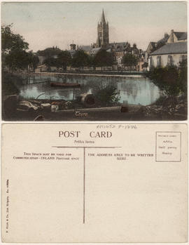
Item is a postcard printed with images of key places in Camborne. This postcard was presented to Mrs. Harrison.
6035 results with digital objects Show results with digital objects
Item is a postcard printed with images of key places in Camborne. This postcard was presented to Mrs. Harrison.

This postcard includes personal correspondence. Sent to Mrs. E. Baggs of Bath, England.

This postcard includes personal correspondence. Sent to Miss. H. Baggs of Bath, England.
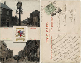
Cornhill and Market street, Highbridge.
Item is a postcard printed with images of two main streets of Highbridge and the town's coat of arms. This postcard includes personal correspondence. Sent to Mr. Arthur Baggs of Bath, England.
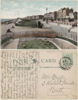
King's road, looking towards Hove.
This postcard includes personal correspondence. Sent to Mrs. Baggs of Bath, England.
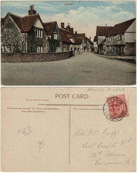
This postcard includes personal correspondence. Sent to Miss H. C. Baggs of Vancouver, B.C.

This postcard includes personal correspondence. Sent to Miss Hilda Baggs of Weston Super Mare, England.


The Cenotaph, Whitehall, London.
This postcard includes personal correspondence. Sent to J. [McKersock?] Esq. of Vancouver, B.C. from A. J. Harrison.

Piccadilly, the Green park and the Quadriga, London.
This postcard includes personal correspondence. Sent to [J?] Robison of Vancouver, B.C. from A. J. Harrison.

This postcard includes personal correspondence. Sent to [Allec Culluch?] of Vancouver, B.C. from A. J. Harrison.

Whitehall & The War Office, London.
This postcard includes personal correspondence. Sent to Mrs. H. Harrison of Vancouver, B.C.

This postcard includes personal correspondence. Sent to Miss [Hilda] Baggs of Bath, England.

This postcard includes personal correspondence. Sent to Ms. L. Baggs of Bath, England.

Part of City of Vancouver Archives technical and cartographic drawing collection
Item is a copy of sections of a November 1889 fire insurance map that have been pieced together. Includes the area between Seymour and Dunlevy Streets, from the south shore of the Burrard Inlet to Keefer Street. Map shows Chinatown, part of False Creek, and buildings and their uses (commercial, residential, industrial). The name of the business, business owner, or type of business is noted for most commercial and industrial buildings.
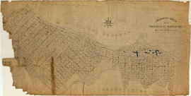
Contour plan of a portion of the City of Vancouver
Part of City of Vancouver fonds
Item is a map of the area from Chilco Street to Raymur Avenue and Coal Harbour/Vancouver Harbour to False Creek showing topographic contour lines, streets, block numbers (in Roman numerals), sewers, manholes, and elevations at various points along streets.

Item is a map of Greater Vancouver showing streets, parks, schools and hospitals; includes street index.
![[Canadian Pacific Railway Pier 'D' fire]](/uploads/r/null/c/f/cf438fa385ddd1f4fef863a0a40f12979362af88e06b942c6a4b9d7457762ea4/56e93e6a-0ceb-4772-b267-0e46f31d9d21-A09130_142.jpg)
[Canadian Pacific Railway Pier 'D' fire]
Part of Major Matthews collection
Photograph shows crowds gathered at foot of Granville Street watching the burning of CPR pier.
![[The intersection of West 41st Avenue and East Boulevard]](/uploads/r/null/3/f/3f8745272c6df898bfb307a131cd05f7d6771cc112277c0363d88bc261d0f497/67da1a2b-6e85-4bb8-b951-8aec15f9ff63-A72364_142.jpg)
[The intersection of West 41st Avenue and East Boulevard]
Photograph shows The Bank of Nova Scotia and other businesses on the southeast corner
![[The intersection of West 41st Avenue and West Boulevard]](/uploads/r/null/2/2/22a76905ef63933c1aa44846fb7e1d99bdff06c62e24598ffbec7542cb7458ac/73805b10-0897-461f-9ccf-7f0916dc2e0d-A72365_142.jpg)
[The intersection of West 41st Avenue and West Boulevard]
Photograph shows The Bank of Montreal on the southwest corner and Carter Pontiac Buick
![[Looking south on West Boulevard from the 5600 Block]](/uploads/r/null/4/a/4a01fab7e369be74da8a846e1a4fa4542f1cc7c7c1b6574f6004d0852b5c636a/b8a74e69-5b5d-4835-a287-d0c81e59a1f1-A72366_142.jpg)
[Looking south on West Boulevard from the 5600 Block]
Photograph shows the Yorkshire Inn and H.A. Roberts Real Estate
![[Looking north along East Boulevard from West 41st Avenue]](/uploads/r/null/3/3/33d1af91875444f1a42b00570aeaccede9cbcd24aa2b1b7472234fa6b68c0cee/b9a8c1c9-553f-40a0-8fdb-ff2a184e97be-A72370_142.jpg)
[Looking north along East Boulevard from West 41st Avenue]
Photograph shows the Kerrisdale Arena and Point Grey Secondary School
![[Looking east along West 41st Avenue from East Boulevard]](/uploads/r/null/f/4/f45df961246ce689a05d6ee05d5c8b10ad1370a7184f1476eff37a7354471997/d8f7ac28-5f53-4b95-8fd8-591ffc652e53-A72371_142.jpg)
[Looking east along West 41st Avenue from East Boulevard]
Photograph shows the Chapel of Chimes, Shamash Creations and other shops and businesses
![[The intersection of West Boulevard and West 41st Avenue]](/uploads/r/null/1/f/1faef7a9c98027c1b32378f0fb73ae3d253e2295d048b120bef9bd0cebace7d4/6b74ae54-437a-4c43-a0db-4d1a73c95ab0-A72372_142.jpg)
[The intersection of West Boulevard and West 41st Avenue]
Photograph shows the Bank of Nova Scotia
![[The intersection of West 41st Avenue and Yew Street looking east]](/uploads/r/null/0/3/03707592446d31ae3603fd5f8ad9f7be48b11f239287ae850daef086e0527eb4/e5015cca-b625-4e79-bccc-89c2f38d62e7-A72373_142.jpg)
[The intersection of West 41st Avenue and Yew Street looking east]
Photograph shows Vanity Lingerie and other shops and busineses
![Christ Church [Burrard and Georgia]](/uploads/r/null/b/b/6/bb6d9aaf58788d31754ba4360f73df1562b183e2d076ea10d5d2edf0e30e06ec/53218777-9467-4721-a1ca-41efc22c872c-CVA99-1438_142.jpg)
Christ Church [Burrard and Georgia]
Part of Stuart Thomson fonds
![George Noble [client] [safety zone (pedestrian island) for street car patrons on Hastings Street]](/uploads/r/null/8/d/2/8d28570481c90c92a7a30e0cd5e7f66e555e50bb9923076966928acaeb36fbcd/495b4cee-f831-4620-a782-ab91f9783c27-CVA99-2619_142.jpg)
George Noble [client] [safety zone (pedestrian island) for street car patrons on Hastings Street]
Part of Stuart Thomson fonds

Development of railway properties at 1st Avenue and Main Street
Part of City of Vancouver fonds
Item is a map depicting proposed street and park developments along Main Street between 1st Avenue and Prior Street.
Vancouver (B.C.). Engineer's Office
![[View of fire at G.H. Cottrell Warehouse, 139 Water Street]](/uploads/r/null/d/4/2/d42e9cc6d0ed113b820738761abee8e002b3343ece277b2d2aa63d56af341039/38d982ad-3791-47df-aa20-a24e3dff0244-CVA354-018_142.jpg)
[View of fire at G.H. Cottrell Warehouse, 139 Water Street]
Part of City of Vancouver fonds
Item is a photograph showing fire fighters climbing a ladder at building with hoses and engines below and spectators watching from below and from across the street at a rooming house.
![[1908 Amoskeag self-propelled steamer with firefighters on street at No. 1 Firehall]](/uploads/r/null/1/3/5/13521aa9822ab0621dd174314ab0da79b3c9464050100ca355b44e2981514ca5/c293057e-0626-45c0-900a-16d6af894027-CVA354-038_142.jpg)
[1908 Amoskeag self-propelled steamer with firefighters on street at No. 1 Firehall]
Part of City of Vancouver fonds
![[Deputy Chief C.W. Thompson at wheel of automobile in front of house, location unknown]](/uploads/r/null/0/7/9/079e0aa56e8021afe42cffa066588b8247abfa2d6241e7fa304e3bba3787c957/9464de60-42fe-4f1c-a30c-109c825dc061-CVA354-054_142.jpg)
[Deputy Chief C.W. Thompson at wheel of automobile in front of house, location unknown]
Part of City of Vancouver fonds
Part of City of Vancouver fonds

Part of City of Vancouver fonds
Part of City of Vancouver fonds

Part of City of Vancouver fonds
![[Firefighters battling blaze at Passlin Hotel, 700 block Richards Street]](/uploads/r/null/5/6/4/5641b5fabc7f3acc6ed04ff5a4536e05e046766e1f840678824809879ab02ac7/4cadeaf9-8ebe-4b5b-97b1-6e7b9af8a59f-CVA354-262_142.jpg)
[Firefighters battling blaze at Passlin Hotel, 700 block Richards Street]
Part of City of Vancouver fonds

The many new hi-rise office and apartment buildings and creating new problems in fire protection
Part of City of Vancouver fonds
![[Firefighters atop aerial ladder in No. 2 Firehall truck on Seymour Street]](/uploads/r/null/e/b/e/ebed39d1a2b9ea2207235d6682e197186c16c1a61362cc398c6b092fea30c2c5/e6eb149a-118a-4ce7-a6e9-1f0c83811b98-CVA354-387_142.jpg)
[Firefighters atop aerial ladder in No. 2 Firehall truck on Seymour Street]
Part of City of Vancouver fonds
Item is a photograph showing five firefighters perched on a ladder next to a two-storey building and pool hall.

This postcard includes personal correspondence addressed to Miss Baggs of Bath.

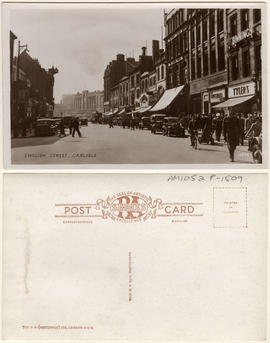
This postcard includes personal correspondence addressed to E. Baggs of Bath.
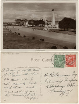
This postcard includes personal correspondence addressed to H. R. Summers[?], Plumbing Inspector, of Vancouver.

This postcard includes personal correspondence addressed to Mrs. Harrison of Montreal.

This postcard includes personal correspondence addressed to Miss H. Baggs of Bath.

This postcard includes personal correspondence addressed to Miss Baggs of Bath.


Severn Avenue, Weston-Super-Mare
This postcard includes personal correspondence addressed to Mr. A. E. Baggs of Worcester.

This postcard includes personal correspondence addressed to Miss Hilda Baggs of Bath.

This postcard includes personal correspondence addressed to Mr. E. Baggs of Bath.