![Rupert [Street] and Broadway [intersection, 3 of 8]](/uploads/r/null/d/b/1/db164234b931eeb7ff7b63cd1c620171d0b162bae1d1eef8c3b2a33d9ab02019/97bd6711-17f4-44ca-be4b-826517a6b74b-2019-103.0518_142.jpg)
Rupert [Street] and Broadway [intersection, 3 of 8]
- COV-S505-1-: 2019-103.0518
- Item
- [198-?]
Part of City of Vancouver fonds
Rupert [Street] and Broadway [intersection, 3 of 8]
Part of City of Vancouver fonds
![Rupert [Street] and Broadway [intersection, 4 of 8]](/uploads/r/null/b/9/a/b9a5967c5cd9b2a999b31eeb5d51389add5b2587d93c15cff9ed1c187613d912/096d787f-1ff7-4ee6-8298-52955e5f7fc5-2019-103.0519_142.jpg)
Rupert [Street] and Broadway [intersection, 4 of 8]
Part of City of Vancouver fonds
![Rupert [Street] and Broadway [intersection, 5 of 8]](/uploads/r/null/c/1/5/c15cddf6990c3c3adcf0d6af91a4da38971affa7b2bf6b2c75fbf63dc65b93e6/375b1af8-c288-44cb-9353-8a7b29561674-2019-103.0520_142.jpg)
Rupert [Street] and Broadway [intersection, 5 of 8]
Part of City of Vancouver fonds
![Rupert [Street] and Broadway [intersection, 6 of 8]](/uploads/r/null/c/6/1/c61314c22a511e82f9867c0e1fcd683acf3429b646ba6fb97d3d576f934fed2d/62054fb6-4f68-4368-b9bb-c23f9a893acf-2019-103.0521_142.jpg)
Rupert [Street] and Broadway [intersection, 6 of 8]
Part of City of Vancouver fonds
![Rupert [Street] and Broadway [intersection, 7 of 8]](/uploads/r/null/7/a/b/7abb597b566dd2d2edbda25b85f43e24aa311b6b661e699742f1035412f2ce63/c7f92de7-b12a-43ff-aed8-75082b7f4f33-2019-103.0522_142.jpg)
Rupert [Street] and Broadway [intersection, 7 of 8]
Part of City of Vancouver fonds
![Rupert [Street] and Broadway [intersection, 8 of 8]](/uploads/r/null/4/3/9/439a7c7c9d6a098061bbe7d3714d88d5b738abbabc3e3f11d43824addcff1061/040da0ca-e08d-4f6a-900e-f34df199613c-2019-103.0523_142.jpg)
Rupert [Street] and Broadway [intersection, 8 of 8]
Part of City of Vancouver fonds
![Rupert [Street] and Broadway [looking] east](/uploads/r/null/1/5/15ec7744fc70a473d7bcd79d3b6081c5d282fc3a46a6712ad684dc7dbc3d7787/8344d9af-2abf-45fc-ad6b-5de344d49fd0-A44291_142.jpg)
Rupert [Street] and Broadway [looking] east
Part of City of Vancouver fonds
![Rupert [Street] and Broadway [looking] north](/uploads/r/null/9/1/91b45078b6a259cbf4c37de44eb7c4968bc49968a97e6248fbd1c51180bd45f8/054cdce4-bed4-4abb-8b2f-fc69026ddf75-A44288_142.jpg)
Rupert [Street] and Broadway [looking] north
Part of City of Vancouver fonds
![Rupert [Street] and Broadway [looking] south](/uploads/r/null/9/e/9e184c15f0d2ff1b4b438022e10153022856ba6e82b9c059b5d91c5161137287/b59c5a84-de22-4667-a46e-97c00a2cdcc9-A44287_142.jpg)
Rupert [Street] and Broadway [looking] south
Part of City of Vancouver fonds
![Rupert [Street] and Broadway [looking] west](/uploads/r/null/b/0/b005a4f0fffb26520c9c4c0537755eb9aeb8894c0dd59a51265f85f959966b2d/fece594d-76e8-4453-a73e-0f8ea86f8765-A44289_142.jpg)
Rupert [Street] and Broadway [looking] west
Part of City of Vancouver fonds
![Rupert [Street] and Grandview [Highway intersection, 1 of 8]](/uploads/r/null/7/2/1/72109d798d9d941ff4b26dd8c42cf86519d7aed40cac5efede696b55a10d8b24/feb50ef5-4614-4c29-8c2f-a2c89ca38c11-2019-103.0507_142.jpg)
Rupert [Street] and Grandview [Highway intersection, 1 of 8]
Part of City of Vancouver fonds
![Rupert [Street] and Grandview [Highway intersection, 2 of 8]](/uploads/r/null/b/8/3/b83a4238b9b7319ae8e980a2e2d94baf5dbed18979ddcf251419d2cc07a7ed82/357598c9-30ad-4fe5-acc5-daf046a887ce-2019-103.0508_142.jpg)
Rupert [Street] and Grandview [Highway intersection, 2 of 8]
Part of City of Vancouver fonds
![Rupert [Street] and Grandview [Highway intersection, 3 of 8]](/uploads/r/null/b/8/1/b81effa5144721282001f2cadb5316443e078a079cd4b629e9c9d682bd699fc0/3ec3f093-29d6-40e1-bc64-bf25859bab73-2019-103.0509_142.jpg)
Rupert [Street] and Grandview [Highway intersection, 3 of 8]
Part of City of Vancouver fonds
![Rupert [Street] and Grandview [Highway intersection, 4 of 8]](/uploads/r/null/d/7/8/d78b4eeaae239e2ba0ddc2d748ee9f502fd0d3e5051d5f38134d21bc77e989bf/fddb8499-b90f-4ceb-9fa8-0fb6bf001bf0-2019-103.0510_142.jpg)
Rupert [Street] and Grandview [Highway intersection, 4 of 8]
Part of City of Vancouver fonds
![Rupert [Street] and Grandview [Highway intersection, 5 of 8]](/uploads/r/null/6/b/0/6b0964520c72d34a8af22c82e15db5f2082ed1d096b9af7192ada0aa28c6c63d/fbea2252-f7a3-4a58-8e19-a1bc8d14d3e5-2019-103.0511_142.jpg)
Rupert [Street] and Grandview [Highway intersection, 5 of 8]
Part of City of Vancouver fonds
![Rupert [Street] and Grandview [Highway intersection, 6 of 8]](/uploads/r/null/3/1/7/317f9da1349f06a4db7eaa3517c3a74e7eaad3319d9bdaee8a4cdfe8fe3ad7f5/4037bbef-175d-4ef6-860d-a6472194eeb5-2019-103.0512_142.jpg)
Rupert [Street] and Grandview [Highway intersection, 6 of 8]
Part of City of Vancouver fonds
![Rupert [Street] and Grandview [Highway intersection, 7 of 8]](/uploads/r/null/8/7/e/87e8615a285e4f14307cfa465b70934f223db0d4e44015e5554de0cfbce59331/b5c51268-ec8d-4d44-9514-2d21ea59efcd-2019-103.0513_142.jpg)
Rupert [Street] and Grandview [Highway intersection, 7 of 8]
Part of City of Vancouver fonds
![Rupert [Street] and Grandview [Highway intersection, 8 of 8]](/uploads/r/null/e/7/f/e7fcc59e47cfecfe613659379b2a4932dbd14dd6cf97bf5240f0e5c2a80d347d/2df07f71-a677-4bd5-a3f9-266ae35c4930-2019-103.0514_142.jpg)
Rupert [Street] and Grandview [Highway intersection, 8 of 8]
Part of City of Vancouver fonds
![Rupert [Street] and Grandview [Highway looking] east](/uploads/r/null/d/3/d30e08d2474a304af76395ff080419e63414ac5efb2c4666bf9e9a024e415a65/495d16a9-accf-4115-922c-45f9fa5ff88c-A44279_142.jpg)
Rupert [Street] and Grandview [Highway looking] east
Part of City of Vancouver fonds
![Rupert [Street] and Grandview [Highway looking] north](/uploads/r/null/c/e/cea32922d2829a351ed9ceae96e10a5df5be95bb8577a30c160e8dbebd34e9ab/7a50a518-4472-4d6b-aaf5-8658c7e9eeb7-A44281_142.jpg)
Rupert [Street] and Grandview [Highway looking] north
Part of City of Vancouver fonds
![Rupert [Street] and Grandview [Highway looking] south](/uploads/r/null/5/d/5d311532cb71ffcef2050ccd6750364440b607a971a4a0c901b038d11d08e8fb/d5704b16-2816-4a04-b2c5-e83e66fb077b-A44282_142.jpg)
Rupert [Street] and Grandview [Highway looking] south
Part of City of Vancouver fonds
![Rupert [Street] and Grandview [Highway looking] west](/uploads/r/null/7/3/73082d5a1769633152e6fbc862ed297d93ac0221ffb02d895546b3babf21b6de/c0fcd2c7-e46a-4c84-8959-4c35a80f619c-A44280_142.jpg)
Rupert [Street] and Grandview [Highway looking] west
Part of City of Vancouver fonds
![Rupert [Street] and Grandview [Highway traffic controller]](/uploads/r/null/a/e/9/ae9a205ef755040e6e61863ccef500aed5f9b1abe42701d1ae82ba314b8c23e6/5133038c-646e-4838-bbe6-c9b6d8a6aad1-2019-103.0515_142.jpg)
Rupert [Street] and Grandview [Highway traffic controller]
Part of City of Vancouver fonds
![Rupert [Street] and Kingsway [intersection, 1 of 4]](/uploads/r/null/d/0/a/d0a66c6731a16a5db272b77434491f8fe32455418522269abaa79457e59fdb5e/b1ac5cee-1002-4159-8da4-0378a35466c5-2019-103.0495_142.jpg)
Rupert [Street] and Kingsway [intersection, 1 of 4]
Part of City of Vancouver fonds
![Rupert [Street] and Kingsway [intersection, 2 of 4]](/uploads/r/null/b/7/1/b7125b25fb087b9c4e2efaeeaa06ac47219550ece7c4976d5235f616c0cd3e5d/083ec2df-0917-4f72-9945-3d2a0d259d0d-2019-103.0496_142.jpg)
Rupert [Street] and Kingsway [intersection, 2 of 4]
Part of City of Vancouver fonds
![Rupert [Street] and Kingsway [intersection, 3 of 4]](/uploads/r/null/c/8/b/c8b046816e9f409a0a897d68949f20f5b7f2aa18a3534ffe1a5e1729faab1e42/ed078617-015c-494f-a11f-d151de367f60-2019-103.0497_142.jpg)
Rupert [Street] and Kingsway [intersection, 3 of 4]
Part of City of Vancouver fonds
![Rupert [Street] and Kingsway [intersection, 4 of 4]](/uploads/r/null/d/1/9/d1990d97250daa5de0994adb0f5efe4a0e089ca70070cced771b1802e69ed936/1f7f8319-a40f-4369-8460-6b038653e54f-2019-103.0499_142.jpg)
Rupert [Street] and Kingsway [intersection, 4 of 4]
Part of City of Vancouver fonds
![Rupert [Street] and Kingsway [looking] east](/uploads/r/null/c/b/cb50a493067f89999836e6a3f8cb225a4ce523510a7531b230f655706ec7e5ee/1d8216b2-26a0-4645-9d05-f19ddfef4b95-A44278_142.jpg)
Rupert [Street] and Kingsway [looking] east
Part of City of Vancouver fonds
![Rupert [Street] and Kingsway [looking] north](/uploads/r/null/e/5/e5dbf55cfa79527ea67a59e0fcb60b06a79241675e458bc432e93189f66b37d6/c6bf0e9b-0b79-4b8b-bfc4-53b2a7c272ea-A44276_142.jpg)
Rupert [Street] and Kingsway [looking] north
Part of City of Vancouver fonds
![Rupert [Street] and Kingsway [looking] south](/uploads/r/null/e/d/eddb0a465733d1ca4a3094d5978302c25a323b2083bbc6515f8fc398bec39734/787bc337-dff9-4d8d-83c1-afdd4d193ace-A44275_142.jpg)
Rupert [Street] and Kingsway [looking] south
Part of City of Vancouver fonds
![Rupert [Street] and Kingsway [looking] west](/uploads/r/null/e/f/ef290b538cc1f8e12172f9c689018000d3bb7fb2940579f730598af2405131a2/d36bb29b-8c02-43d2-956a-e70068846e82-A44277_142.jpg)
Rupert [Street] and Kingsway [looking] west
Part of City of Vancouver fonds
![Rupert [Street] and Kingsway [traffic controller]](/uploads/r/null/3/3/7/337eea3b1322870b674567e971f7598acc65a1069f3a13a4fac372a819b2ed85/961594e7-4657-4e15-b7ae-4169d227f52e-2019-103.0498_142.jpg)
Rupert [Street] and Kingsway [traffic controller]
Part of City of Vancouver fonds
![Safeway Free Cooking School [at Vancouver Theatre, 765 Granville]](/uploads/r/null/9/d/9da32e7dd26cd60112985112388a252b57fac8e30f98794d6737ac4ac76fe3c3/22181493-4f99-4e7a-85ff-a0045188e09a-A01405_142.jpg)
Safeway Free Cooking School [at Vancouver Theatre, 765 Granville]
Part of Stuart Thomson fonds
![Sales Comparison # 1 58 to 62 Powell [Street]](/uploads/r/null/7/8/789929b66c285013d48ccf10bf2c0ad918953fb1739f985b8bec2b8a08dbbc1a/dfa8c94f-fcb6-4c09-9961-13fe1f7c1b70-CVA810-65_142.jpg)
Sales Comparison # 1 58 to 62 Powell [Street]
Photograph shows the 58 to 62 Powell Street from across Powell Street. The alley behind the building and parked cars are visible in the photograph. Businesses shown Raymond Chow Art Gallery.
![Sales Comparison # 1 610 W. Cordova [Almer Hotel]](/uploads/r/null/7/9/79f34b62ccc99b7193ec72bff2412b031e501e6fac031a772efcfa0e74c63c84/5fc265d4-7ea9-4d3c-8eef-cc34800df36a-CVA810-43_142.jpg)
Sales Comparison # 1 610 W. Cordova [Almer Hotel]
Photograph shows the Almer Hotel on West Cordova Street and the St. Francis Hotel to its left. Cars are parked on the street in front of the hotels. The photograph is taken from across Cordova Street. Hotel is visible in the background.
![Sales Comparison # 2 2 to 14 W. Pender [Street]](/uploads/r/null/f/e/feba970c3074cedec8ee36b0b2ff329a63d96f2432883c172993e141a0821be9/8dfd6268-386d-47a4-b2c7-63ad8b932f1d-CVA810-66_142.jpg)
Sales Comparison # 2 2 to 14 W. Pender [Street]
Photograph shows 2 to 14 West Pender Street from across Pender Street. Street lights and wires are visible in the photograph. Businesses shown ? Kong Silk.
![Sales Comparison # 2 553 to 555 Hamilton Street [Del Mar Hotel]](/uploads/r/null/3/6/36c4169759a030741cbced2c75a2479ba1a81a075b71697e494ecc949f96d3fc/e9d899b9-24f1-490c-b5e6-26c2a0349d1b-CVA810-44_142.jpg)
Sales Comparison # 2 553 to 555 Hamilton Street [Del Mar Hotel]
Photograph shows the Del Mar Hotel on Hamilton Street in Gastown with a parking lot on the right. Cars are parked in the parking lot and in front of the hotel. The photograph is taken from across Hamilton Street.


Item is a slide used to accompany the presentation "The Townsite Story".
![Sanitation [3 of 12]](/uploads/r/null/8/5/85629ab6750b6e26418478b394c9ca78aaaadb64e02750f4915b82adca9df37b/6d8caf8b-c024-40ac-989c-0ef9019fc018-A64441_142.jpg)
Part of City of Vancouver fonds
![Sasamat [Street] and 10th [Avenue intersection, 1 of 4]](/uploads/r/null/1/0/b/10b89791738c1c62341023c2e6192c10d0ce336de91f15795f580cd3503962bb/d9d3943d-5eba-4e90-9af0-419bda5dfe92-2019-103.0301_142.jpg)
Sasamat [Street] and 10th [Avenue intersection, 1 of 4]
Part of City of Vancouver fonds
![Sasamat [Street] and 10th [Avenue intersection, 2 of 4]](/uploads/r/null/f/4/9/f491239e9d71b5d05193fffe0474eb9333647109d915d37e3ad1b4aea9bf28b1/ad83ecbc-b145-465f-b5eb-c953899a9da7-2019-103.0302_142.jpg)
Sasamat [Street] and 10th [Avenue intersection, 2 of 4]
Part of City of Vancouver fonds
![Sasamat [Street] and 10th [Avenue intersection, 3 of 4]](/uploads/r/null/6/f/f/6ff3e887b3dbe6875023a6c16a67e2e857781718e063c6b05ff315d2430adf96/aeaeabc8-30e0-48d1-a107-574a5db2420f-2019-103.0303_142.jpg)
Sasamat [Street] and 10th [Avenue intersection, 3 of 4]
Part of City of Vancouver fonds
![Sasamat [Street] and 10th [Avenue intersection, 4 of 4]](/uploads/r/null/6/f/5/6f5547fe20532a23ba3cd1865c55555d55735217258c6196fb3b7e37e67646dc/e1800e49-19d4-46a6-ad84-0cb9d8b99297-2019-103.0304_142.jpg)
Sasamat [Street] and 10th [Avenue intersection, 4 of 4]
Part of City of Vancouver fonds
![Sasamat [Street] and 10th [Avenue traffic controller]](/uploads/r/null/e/a/d/ead35ff064be8d64b22ce16957d98c98882d6c8a49b008ff8502ca17583d87f0/22e73f54-693a-4cc3-8492-aee4a581788d-2019-103.0305_142.jpg)
Sasamat [Street] and 10th [Avenue traffic controller]
Part of City of Vancouver fonds
![Schou [Street] and Canada Way [looking] west](/uploads/r/null/8/0/8005aaa4caa8d824bd5cd65ea4fa590aafbb9cdfcfe71df5bacf3ff6d279d6c4/73562fd4-d35a-46f8-8bb5-373e167c3a2d-A42833_142.jpg)
Schou [Street] and Canada Way [looking] west
Part of City of Vancouver fonds
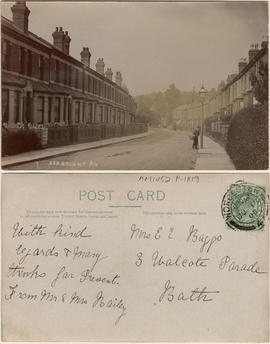
This postcard includes personal correspondence addressed to Mrs. E. C. Baggs of Bath.

Item is a photograph on an album page, annotated with "An example of conditions often met with. On the left (North side of street) the sidewalk is on the inside, with outer boulevard; on the right the sidewalk is constructed to the kerb, with inner boulevard. Proper boulevarding under such conditions is impossible. Note the forest maples planted closely together on the left and the occasional tree on the opposite side. An application is on file requesting the City to remove these trees entirely, so as to permit light and air to the houses and to make more effective street lighting at night."

Second slide in set to accompany The Townsite Story
Part of BC Gay and Lesbian Archives