![Schou [Street] and Canada Way [looking] west](/uploads/r/null/8/0/8005aaa4caa8d824bd5cd65ea4fa590aafbb9cdfcfe71df5bacf3ff6d279d6c4/73562fd4-d35a-46f8-8bb5-373e167c3a2d-A42833_142.jpg)
Schou [Street] and Canada Way [looking] west
- COV-S505-1-: CVA 772-177
- Item
- [between 1980 and 1997]
Part of City of Vancouver fonds
343 results with digital objects Show results with digital objects
Schou [Street] and Canada Way [looking] west
Part of City of Vancouver fonds
Second floor plan : house for C.J. Peters, Esq.
Part of Ross A. Lort, Architect fonds
Address: Burnaby - Esmond Avenue at Trinity Street
Section [for C.J. Peters' residence, Esmond and Trinity]
Part of Ross A. Lort, Architect fonds
Address: Burnaby - Esmond Avenue at Trinity Street
Section through wall : house for E.B. Hermon, Esq., Vancouver Heights [Burnaby]
Part of Ross A. Lort, Architect fonds
Sectional map and street directory of Vancouver : Dial map of the city of Vancouver
Item is a street map showing Vancouver on one side and Burnaby and New Westminster on the other, as well as information on street car and bus routes, and text advertising the products and services of the Dominion Map and Blueprint Company.
Sectional map and street directory of Vancouver : Dial map of the city of Vancouver
Part of City of Vancouver Archives technical and cartographic drawing collection
Item is a street map showing Vancouver on one side and Burnaby and New Westminster on the other, as well as information on street car and bus routes, and text advertising the products and services of the Dominion Map and Blueprint Company.
Part of City of Vancouver Archives technical and cartographic drawing collection
Item is a street map showing Vancouver, Burnaby, New Westminster, West Vancouver, and North Vancouver on one side and the Lower Mainland from Vancouver to Chilliwack on the other. Item includes lists of businesses, schools, public buildings, hospitals, bathing beaches, fire halls, and golf and country clubs, as well as text advertising the products and services of the Dominion Map and Blueprint Company.
Item is a street map showing Vancouver, Burnaby, New Westminster, West Vancouver, and North Vancouver on one side and Lulu Island and Sea Island, Delta, Surrey, Langley and Maillardville on the other.
Sewer capability (Burnaby, B.C.)

Shell Oil Company opening of new plant at Shellburn

Shell Oil Company opening of new plant at Shellburn
Photograph shows a CKWX microphone

Shell Oil Company opening of new plant at Shellburn

Shell Oil Company opening of new plant at Shellburn

Shell Oil Company opening of new plant at Shellburn

Shell Oil Company opening of new plant at Shellburn
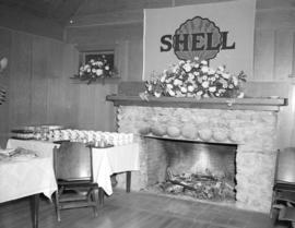
Shell Oil Company opening of new plant at Shellburn

Shell Oil Company opening of new plant at Shellburn

Shell Oil Company opening of new plant at Shellburn
Photograph shows the "Lady Rose"

Side view of old "1222" which was the last tram to run on the Steveston Interurban Line
Part of Major Matthews collection
Photograph was taken at Edmonds
Simon Fraser University and primary access roads

Simon Fraser University, Burnaby 2, B.C., Canada : aerial looking east
Item is a postcard showing an aerial view of Simon Fraser University. The back of the postcard includes personal correspondence addressed to Elizabeth Schuler.
![[Snow filled street in Burnaby Heights]](/uploads/r/null/2/2/6/226a4eced53cb919bf0c91c5db6a92dc56b44767e0a3e587c3a798bbe9a1cfdf/9d35b236-40a3-4369-8af5-6f431286d281-CVA260-1603_142.jpg)
[Snow filled street in Burnaby Heights]
Part of James Crookall fonds
![[Snow filled street in Burnaby Heights]](/uploads/r/null/c/4/b/c4b315278d9f18b1bd9a64d6762084349d868045cebe74f8cbaf1f92c9653452/adc2c63c-1c82-47fc-af17-c1adeebd5d50-CVA260-1604_142.jpg)
[Snow filled street in Burnaby Heights]
Part of James Crookall fonds
![[Snow filled street in Burnaby Heights]](/uploads/r/null/a/e/c/aec6854830a857de74291d512650b2e0b0107e977595badfc7586ce5b6ce13cb/3575ad2a-f55e-435e-aa04-0e5a9eb5a7ce-CVA260-1605_142.jpg)
[Snow filled street in Burnaby Heights]
Part of James Crookall fonds
![[Snowy view from the back porch of James Crookall's house at 3746 Eton Street]](/uploads/r/null/b/8/a/b8a56faf992dcd8e9f1c7d167bd31f5e93000705653817fef032bf6b5f715fee/cbcd9698-83ed-42ca-9960-493ed9d3f922-CVA260-1602_142.jpg)
[Snowy view from the back porch of James Crookall's house at 3746 Eton Street]
Part of James Crookall fonds
South elevation : house for C.J. Peters, Esq., Vancouver Heights
Part of Ross A. Lort, Architect fonds
Address: Burnaby - Esmond Avenue at Trinity Street
South elevation : house for E.B. Hermon, Esq., Vancouver Heights [Burnaby]
Part of Ross A. Lort, Architect fonds
![[Sperling Avenue looking east]](/uploads/r/null/f/9/f920da06add889342c9a54d316497cf061e5c872aa3e486d9fb36a80d8574efb/b6b9d303-f8c5-4376-9205-f4d4682e0afd-A09329_142.jpg)
[Sperling Avenue looking east]
Part of Major Matthews collection
Photograph shows Neale house on northeast corner of Sperling Avenue and Lougheed Highway surrounded by fields and vacant land. Railway tracks visible in the distance.
![[Sperling Avenue looking east]](/uploads/r/null/a/b/ab3bfc916b6f2fbf01857de7d3408c89a440eaebcb36d3c2cc2e077f3a24345b/4e8da1c5-f7c0-4f8f-ae87-e51a89a9e770-A09328_142.jpg)
[Sperling Avenue looking east]
Part of Major Matthews collection
Photograph shows Neale house on northeast corner of Sperling Avenue and Lougheed Highway surrounded by fields and vacant land. Railway tracks visible in the distance.

St. Andrew's Presbyterian Church Central Park
Part of Major Matthews collection

St. John the Divine Anglican church at 3895 Kingsway
![[St. Nicholas Parish Church]](/uploads/r/null/9/0/90336e9fa34f23a68dcebab56be65461664582663a067adc91311c029f4a5a5f/526fef8a-b9a8-45b6-895a-208dccb84b95-A09141_142.jpg)
Part of Major Matthews collection
Photograph shows Anglican church at corner of Triumph Street and Ingleton Street, Burnaby.
Standard Oil of B.C. refinery office building : 4473 McGill Street, Burnaby
Part of C.B.K. Van Norman fonds
File consists of the following types of architectural drawings: site plans, elevations, floor plans, sections and details
![[Steel frame of partially constructed Horne Payne substation]](/uploads/r/null/6/4/64ec79ae416c07e5a65e39a1f07ebf5e5e8138821042dabd466f4374f64e935d/cb5acfae-3cd9-4a1b-90d1-5bdd56eb6635-A08444_142.jpg)
[Steel frame of partially constructed Horne Payne substation]
Part of Major Matthews collection
Part of Stuart Thomson fonds
![[Storage tanks and railway tanks at Imperial Oil Company refinery in Burnaby]](/uploads/r/null/2/9/29298d2d4c4158d8ab8d64f03db4b855f796b6c4d175e425e3ef14661a8abf19/3e57fc76-b39b-47ad-b78e-47f9b971df8a-A08036_142.jpg)
[Storage tanks and railway tanks at Imperial Oil Company refinery in Burnaby]
Part of Major Matthews collection
J.S. Matthews' notes with print or negative in Archives.
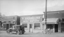
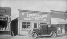
Storefront of B. Shewbrooks "The Man on the Spot" Real Estate, Insurance, Architect
Photograph shows B. Shewbrooks storefront located at 4513 Kingsway, including the Red and White store and Wigley Meat Market.
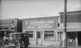
Storefront of B. Shewbrooks "The Man on the Spot" Real Estate, Insurance, Architect
Photograph shows B. Shewbrooks storefront located at 4513 Kingsway, including the Red and White store and Wigley Meat Market.
Storefront of B. Shewbrooks "The Man on the Spot" Real Estate, Insurance, Architect
Photograph shows B. Shewbrooks storefront located at 4513 Kingsway, including the Red and White store and Wigley Meat Market.
![[Students of the first public school near the southeast corner of Edmonds Street and Douglas Road]](/uploads/r/null/b/6/b623f88197af9f78121fd65e2ea78e5d5ef265a3ed8922be9b90624ddaf36416/f83d66a8-ea25-40ad-9175-18f6bf1eccdf-A36438_142.jpg)
[Students of the first public school near the southeast corner of Edmonds Street and Douglas Road]
Part of Major Matthews collection
Group portrait showing Trustees B.R. Hill, L. Grimmer and William McDermott and the children
Subdivision and land use : residential analysis (Burnaby, B.C.)
Subdivision and land use (Burnaby, B.C.)
Subdivision and land use (Burnaby, B.C.)
Subdivision and land use (Burnaby, B.C.)
Suggestion for layout of grounds for C.J. Peters, Esq.
Part of Ross A. Lort, Architect fonds
Address: Burnaby - Esmond Avenue at Trinity Street
![Taken for Duker and Shaw Billboards Ltd. [Kingsway and Patterson]](/uploads/r/null/e/4/e4a8244ab612b09825e93b392a376780c1d7abe042605aa020b78526e5a03bc9/28e2596b-98a2-4594-a7a1-05ed5fbfb100-A00930_142.jpg)
Taken for Duker and Shaw Billboards Ltd. [Kingsway and Patterson]
Part of Stuart Thomson fonds
![[The 2nd Battalion, Canadian Garrison Artillery at Central Park Rifle Range]](/uploads/r/null/1/5/15534f2bbf9bead05a9d594322ee886c2498228fd43fb14e44d4de5d333b7bfe/a7f58baf-0ab5-44ef-b9ee-83bdcd3fdde9-A32064_142.jpg)
[The 2nd Battalion, Canadian Garrison Artillery at Central Park Rifle Range]
Part of Major Matthews collection
Group portrait showing Lieutenant J. Reynolds Tite, Corporal J. Sperring, Gunner William Croy and others