
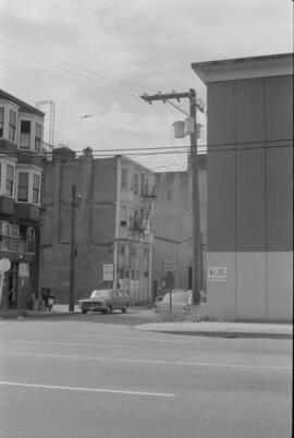
East 15th Ave., facing west towards Knight St.
- AM757-S2-F3-: CVA 798-6.20
- Item
- 1989
Photograph taken from corner of East 15th Avenue and Fleming Street, showing dip in land where China Creek once flowed. To the right is Clark Park.
3815 results with digital objects Show results with digital objects
East 15th Ave., facing west towards Knight St.
Photograph taken from corner of East 15th Avenue and Fleming Street, showing dip in land where China Creek once flowed. To the right is Clark Park.

East 15th Ave., facing west towards Knight St.
Photograph taken from corner of East 15th Avenue and Fleming Street, showing dip in land where China Creek once flowed. To the right is Clark Park.
![[One way traffic Seymour St. at Georgia Street, looking south]](/uploads/r/null/6/a/6ab5722dd80ce8659c50534737b97713ef7378106e8777583f6504275d6eb353/28fb7cc1-f428-4efb-9354-3631dfad7020-A43714_142.jpg)
[One way traffic Seymour St. at Georgia Street, looking south]
Part of City of Vancouver fonds
![Naval parade and review [Cambie and West Hastings]](/uploads/r/null/6/e/6eb34cc2d7a336262d8897a793cc11faface3f399fd4d32b966507b117f84be3/6bd11750-ca63-4a9a-8a15-997e4ab35d60-A00552_142.jpg)
Naval parade and review [Cambie and West Hastings]
Part of Stuart Thomson fonds
![[Pender Street at Cambie Street, looking west]](/uploads/r/null/3/d/3d91c3d4cd2181022a308d60e8fad6da587efcfa17cc0a68527eb95c215bc009/5a8ff240-1741-4881-b137-7b3a66b98a1d-A43705_142.jpg)
[Pender Street at Cambie Street, looking west]
Part of City of Vancouver fonds
Photograph shows the Vancouver Sun sign, City Health Department building and Central Public School
![Miscellaneous [66 of 130]](/uploads/r/null/f/3/f3e5c735d932ae4b6cf5264ac1126704a320ba278c9197a1e374be368226338b/a99fc078-5f61-4e29-b051-d858f0963d35-A64400_142.jpg)
Part of City of Vancouver fonds
Item is a photograph showing a woman walking along the street end at Robson and Chilco with a partial view of Stanley Park in the background.
![Miscellaneous [41 of 130]](/uploads/r/null/5/e/5e42ab92f4cae68f59e04f28d6c5796d7a4a008adc11be6e92a097993d27c4cf/850f5829-2350-4212-bfdb-20c86d11b5a2-A64367_142.jpg)
Part of City of Vancouver fonds
Item is a photograph showing Robson Street between Burrard and Bute.
![[View of 900 block Seymour Street]](/uploads/r/null/8/a/8a5b02b2c474bf4b469da2d909bb54224b911318574331cce7bc62d4574553c8/7f06889b-efed-40ae-b34c-c6615fa12dd1-CVA810-93_142.jpg)
[View of 900 block Seymour Street]
Sign for Dominion Motors can be seen.

Part of City of Vancouver fonds
![Historical Area - 443A [1 of 2]](/uploads/r/null/a/d/b/adb0501965fd81e60dbe21d2588f6e4284600055d7da6abf19e056deee002c4f/a9fa9394-c4fe-434a-809b-207f4479fa58-CVA1095-08891_142.jpg)
Historical Area - 443A [1 of 2]
Part of City of Vancouver fonds
![Historical Area - 443 [Intersection]](/uploads/r/null/8/4/1/841a6ccb61fdb89b8aeec0037649cbd2b29f6f7011b4122a76aa858c1e93279d/743c7c53-8842-4cd5-b900-46b41849bb4d-CVA1095-08925_142.jpg)
Historical Area - 443 [Intersection]
Part of City of Vancouver fonds
Miscellaneous Historical Area - 439
Part of City of Vancouver fonds
Visible is a sign for 22 West Pender Street.

Sheet G : Trafalgar Street to Granville Street and Sixteenth Avenue to Nanton Avenue
Part of City of Vancouver Archives technical and cartographic drawing collection
Item is a section showing the area from Trafalgar Street to Granville Street and Sixteenth Avenue to Nanton Avenue. Includes streets and roads; blocks, lots and legal descriptions; and parks, schools, railway lines and golf courses.
Vancouver (B.C.). Office of the City Engineer
![[West 13th Avenue and Spruce Avenue intersection]](/uploads/r/null/8/8/a/88ae11c41de429c1baddd060cec00115208eecc9f90990d579e57e1e62b79258/ac78c751-ed15-4834-b82e-71a35509a36e-CVA1095-12850_142.jpg)
[West 13th Avenue and Spruce Avenue intersection]
Part of City of Vancouver fonds
![[Cement truck and buildings]](/uploads/r/null/b/0/2/b0276df1352734ab21424f4d2a3dc49856f2f9ef352b9271d842f816bb3e7ab1/9c7ddf9c-7408-4140-bb1b-656ffda9322f-CVA1095-14390_142.jpg)
Part of City of Vancouver fonds
![[Celebration at West Hastings and Carrall Streets looking west]](/uploads/r/null/a/e/aed53fbaee4a486c48ee8542c2ad278eb674183067a4a2f474b780ad55baf1bf/80b73d52-91d1-46da-81d0-3c8f31ead92c-A01814_142.jpg)
[Celebration at West Hastings and Carrall Streets looking west]
Photograph shows a band, horse drawn carriages, spectators, and a large horse-drawn structure decorated with Union Jack flags. Also shown are the Palace Hotel at 349 - 359 Carrall Street and the English Chop House at 377 Carrall Street.
![[Cars on downtown street]](/uploads/r/null/3/7/0/370161e5c83baa350fb19962992c2cef314e83e1c8892e90f21fc1a516302003/6132a451-7e8c-4d90-b4a0-3e38d9d28a0a-CVA1095-15067_142.jpg)
Part of City of Vancouver fonds
![Roll "A" [Tree lined street, 1 of 2]](/uploads/r/null/3/9/6/39692c4eff909a6949713f77238b05f2825dfcb53e196521367170bef9dfd1ee/1f73541f-e180-4c14-95b2-8ed21f5d3b95-2019-103.0001_142.jpg)
Roll "A" [Tree lined street, 1 of 2]
Part of City of Vancouver fonds
![Roll "A" [Tree lined street, 2 of 2]](/uploads/r/null/5/3/3/5333ab20a22079269440fab6b6fbc8d1c3446ace9624f87c338825f39d793362/0722c324-2094-4071-ad02-782fbfa4d708-2019-103.0002_142.jpg)
Roll "A" [Tree lined street, 2 of 2]
Part of City of Vancouver fonds
![Roll "A" [Sidewalk]](/uploads/r/null/e/c/4/ec45e8175582399f7b97ad230a4f32e5e7263a72efd9ed9b9b6a28bc16ecc7e2/cad72f96-ecd5-48a6-bd55-19c0e1622ce5-2019-103.0003_142.jpg)
Part of City of Vancouver fonds
![Roll "A" [Parked cars on street]](/uploads/r/null/1/8/a/18a4c53216377962506c12c71f0ee9702f13cc1f46fc9f5b6fa0d62ba127d532/b1136924-de0d-4160-9606-a081bbe84b33-2019-103.0004_142.jpg)
Roll "A" [Parked cars on street]
Part of City of Vancouver fonds
![Roll "A" [Street]](/uploads/r/null/b/a/6/ba670f47f0786d036ca0e7a8ac3198fe1c4fcddc1a339c17ca81e175410e20b6/2768ac76-b4f2-4da2-a8a8-6e4e675e48f2-2019-103.0005_142.jpg)
Part of City of Vancouver fonds
![Roll "A" [Street]](/uploads/r/null/8/3/8/838e87b85669fad04ddcf36d205b58a49efb24cded140ad35643831f2621eb32/70f81c32-89a1-4d56-8c9a-20e472e0daa6-2019-103.0008_142.jpg)
Part of City of Vancouver fonds
![Roll "A" [Street]](/uploads/r/null/b/0/8/b08b68606ef56262103e922a0f1e121df41aed2484a1a3967ee1c0a1c41bb0a0/30d5e6d3-3ee0-49bb-add5-1a55fe05ca03-2019-103.0009_142.jpg)
Part of City of Vancouver fonds
![Roll "A" [Street]](/uploads/r/null/b/d/8/bd890a86646f73bbc060f725b075ed611d4c5bf90cf76ecb95754297ccafda75/fd573cec-9dbc-4f48-8626-7c0cd5e996ad-2019-103.0010_142.jpg)
Part of City of Vancouver fonds
![Roll "A" [Street]](/uploads/r/null/5/4/c/54cda0d7cce111a5729c470dab0760e3a0d109590d13b8c2a971d60960a2957c/24eb74d1-8207-4db7-87a6-06829e00c181-2019-103.0011_142.jpg)
Part of City of Vancouver fonds
![RLS [Intersection]](/uploads/r/null/9/a/5/9a50e1cf72cf7dcd74c15366f787afd9cacdc69be54a99ddbf30e5f032c21f2e/799b6320-49e5-4eb4-83b6-ed260800df48-2019-103.0065_142.jpg)
Part of City of Vancouver fonds
![RLS [Intersection]](/uploads/r/null/6/d/f/6dfe88a0d740cf69f057aa49afaac2c09edd88135ab5d099050e2a9fd0d6d68a/f6cf2dc2-f41c-4d10-89a8-5511543dfd33-2019-103.0066_142.jpg)
Part of City of Vancouver fonds
![Granville [Street] and 33rd [Avenue intersection, 1 of 4]](/uploads/r/null/4/a/0/4a0b9e3a3cd1d77cd46f318e8ce1fce3616fc15ca64f35c791742384fac844b1/327f34af-3dba-4343-970d-0e706f3ec2e4-2019-103.0177_142.jpg)
Granville [Street] and 33rd [Avenue intersection, 1 of 4]
Part of City of Vancouver fonds
![Granville [Street] and 33rd [Avenue intersection, 2 of 4]](/uploads/r/null/2/b/f/2bfa31035b67500a64b45e67265c67c268310ca782b937db7dc598e49bc3568c/53f92e4a-17b2-4145-90a4-9e65c7835dbf-2019-103.0178_142.jpg)
Granville [Street] and 33rd [Avenue intersection, 2 of 4]
Part of City of Vancouver fonds
![Granville [Street] and 33rd [Avenue intersection, 3 of 4]](/uploads/r/null/5/3/0/5305b8140ad6c27c8463f3c53426d060534bf143f63955aaee5168ec6a7fb9ee/0558afbb-c94f-48d0-89c5-6d349a3ae9bd-2019-103.0179_142.jpg)
Granville [Street] and 33rd [Avenue intersection, 3 of 4]
Part of City of Vancouver fonds
![Granville [Street] and 33rd [Avenue intersection, 4 of 4]](/uploads/r/null/f/0/c/f0cca0e3b5563b27bbc2087a8114fb0029fd35a605d625f97ef1f4fd05b601b6/3e260962-7ab9-4be2-afa2-ce8cb1029070-2019-103.0180_142.jpg)
Granville [Street] and 33rd [Avenue intersection, 4 of 4]
Part of City of Vancouver fonds
![Granville [Street] and 33rd [Avenue traffic controller]](/uploads/r/null/b/0/6/b06d8eb343fa99c178148439284e2a6abb6aa2f34b6a889cf8838a3440660ee8/c2033343-3288-4797-8292-1b97b9eaa34f-2019-103.0181_142.jpg)
Granville [Street] and 33rd [Avenue traffic controller]
Part of City of Vancouver fonds
![Oak [Street] and 37[th Avenue intersection, 1 of 4]](/uploads/r/null/8/f/b/8fbfea577e57c5250bc2084a008a8ffa6bf62ae60c51117ac2a09c0e96ddd162/455e8d6c-120e-4e79-af09-3e54fd0109bc-2019-103.0234_142.jpg)
Oak [Street] and 37[th Avenue intersection, 1 of 4]
Part of City of Vancouver fonds
![Oak [Street] and 37[th Avenue intersection, 2 of 4]](/uploads/r/null/f/d/0/fd0fc0631952023f7d3cbd706b3c85c278f7f5d06dcfcd53ec3dd1cbc753ded4/51d203e9-92b3-47ba-a70f-079521382c1d-2019-103.0235_142.jpg)
Oak [Street] and 37[th Avenue intersection, 2 of 4]
Part of City of Vancouver fonds
![Oak [Street] and 37[th Avenue intersection, 3 of 4]](/uploads/r/null/b/1/6/b16664511a0257ea5ad6d2ca90d1f91d5dad61eee726e395c86c62fc412e784b/87e4bc69-d13d-45a4-9690-b621e90f3f53-2019-103.0236_142.jpg)
Oak [Street] and 37[th Avenue intersection, 3 of 4]
Part of City of Vancouver fonds
![Oak [Street] and 37[th Avenue intersection, 4 of 4]](/uploads/r/null/7/7/2/772b7456ced291ae94a73f7b39cb9680d9149d3d233b8fe0f1b2bcf3b4a64fce/f4935c98-17a8-4d2f-a1bd-d985b4077e00-2019-103.0237_142.jpg)
Oak [Street] and 37[th Avenue intersection, 4 of 4]
Part of City of Vancouver fonds
![Oak [Street] and 37[th Avenue traffic controller]](/uploads/r/null/d/0/6/d06d9ba739b71eb1bf3a0b56b33fb10d97437abe119ec59d3e186c9141a8059f/fcf7afc8-1314-4eb5-8b9f-12ddfa2d4bf5-2019-103.0238_142.jpg)
Oak [Street] and 37[th Avenue traffic controller]
Part of City of Vancouver fonds
![Oak [Street] and 33[rd Avenue traffic controller]](/uploads/r/null/2/7/c/27cfd0709281fb46a4e746314267625e0481e65b05d6230eac2c3243e0cc59b1/9b2fb459-4870-45a7-ad86-12270f4dd772-2019-103.0239_142.jpg)
Oak [Street] and 33[rd Avenue traffic controller]
Part of City of Vancouver fonds
![Oak [Street] and 33[rd Avenue intersection, 1 of 2]](/uploads/r/null/4/1/0/4105a55c2167304ac8977c060155fd5df2332927d670cb0c618dbcbba5b7be40/56498038-d394-44a5-96e0-ca6e04c3fa23-2019-103.0240_142.jpg)
Oak [Street] and 33[rd Avenue intersection, 1 of 2]
Part of City of Vancouver fonds
![Oak [Street] and 33[rd Avenue intersection, 2 of 2]](/uploads/r/null/8/5/7/857fcac98e0e17c105785032d679259bd87748deb76a9cab6619d6d798dfb35e/19d5da68-f820-46d9-958f-b234455d49bc-2019-103.0241_142.jpg)
Oak [Street] and 33[rd Avenue intersection, 2 of 2]
Part of City of Vancouver fonds
![Oak [Street] and 33[rd Avenue intersection, 1 of 3]](/uploads/r/null/3/2/1/32116975b5f4dfbe525d77eab79214cd220c10cea8713e39c6f00015d25b4199/1f1c7f19-df3c-4f99-aa96-1109aac15308-2019-103.0242_142.jpg)
Oak [Street] and 33[rd Avenue intersection, 1 of 3]
Part of City of Vancouver fonds
![Oak [Street] and 33[rd Avenue intersection, 2 of 3]](/uploads/r/null/9/1/9/9194a73f5482712688d4c9c895428dc7ad75c81021abed11717f1a4f6692d4a3/bd3a2f19-382b-4eb5-a6a4-21941fa7c532-2019-103.0243_142.jpg)
Oak [Street] and 33[rd Avenue intersection, 2 of 3]
Part of City of Vancouver fonds
![Oak [Street] and 33[rd Avenue intersection, 3 of 3]](/uploads/r/null/b/a/4/ba47e99d39632155dcb2146b1def2d63c26464f555ddb2dfdb8a2cde1ded591b/c6f9a3b9-f271-40d7-bcfe-1a8b1ee80b87-2019-103.0244_142.jpg)
Oak [Street] and 33[rd Avenue intersection, 3 of 3]
Part of City of Vancouver fonds
![Oak [Street] and Devonshire [Crescent intersection, 1 of 4]](/uploads/r/null/2/9/3/2937916e041d43efaf747dda29156810bad123a8f94f704eb67259c70031bc95/4fd48410-f954-435d-a954-eaa0d8be707f-2019-103.0245_142.jpg)
Oak [Street] and Devonshire [Crescent intersection, 1 of 4]
Part of City of Vancouver fonds
![Oak [Street] and Devonshire [Crescent traffic controller]](/uploads/r/null/9/2/2/922edacda827d3d1939e92def1f276919864314591e66a490c3c8603e9238156/bb4df109-60d9-4568-90eb-80e144f877c0-2019-103.0246_142.jpg)
Oak [Street] and Devonshire [Crescent traffic controller]
Part of City of Vancouver fonds
![Oak [Street] and Devonshire [Crescent intersection, 2 of 4]](/uploads/r/null/3/5/e/35e27508a46400a1f680e812331895047e8e8744ed531545eb6a611dd84a1fc0/de2895b4-c423-4792-a8ee-76e8df4c0801-2019-103.0247_142.jpg)
Oak [Street] and Devonshire [Crescent intersection, 2 of 4]
Part of City of Vancouver fonds
![Oak [Street] and Devonshire [Crescent intersection, 3 of 4]](/uploads/r/null/1/d/f/1df6b8f368d58f2708ed6fd7f95164c6d7a0e62f4affffcbac181f754bc82e02/145b1fac-6c0b-4c3a-b813-4d347c950833-2019-103.0248_142.jpg)
Oak [Street] and Devonshire [Crescent intersection, 3 of 4]
Part of City of Vancouver fonds
![Oak [Street] and Devonshire [Crescent intersection, 4 of 4]](/uploads/r/null/7/8/9/789dcb018b0f2dcb279b22a3703bea68ad39779f02fc39792cba73ae18838c7f/b7bfacfc-2721-41a4-9a28-e8358ec3c2a6-2019-103.0249_142.jpg)
Oak [Street] and Devonshire [Crescent intersection, 4 of 4]
Part of City of Vancouver fonds
![Oak [Street] and King Edward [Avenue intersection, 1 of 4]](/uploads/r/null/7/5/d/75d1fc983cc66666cfda682d41e926df4ce621aedc7ac19629ef97b5df9b057b/1b0bd632-4877-4ad2-956e-adb9ef0c0ffa-2019-103.0250_142.jpg)
Oak [Street] and King Edward [Avenue intersection, 1 of 4]
Part of City of Vancouver fonds