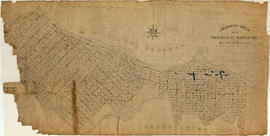
Contour plan of a portion of the City of Vancouver
- COV-S365-: MAP 715
- Item
- Aug. 26, 1889-1913
Part of City of Vancouver fonds
Item is a map of the area from Chilco Street to Raymur Avenue and Coal Harbour/Vancouver Harbour to False Creek showing topographic contour lines, streets, block numbers (in Roman numerals), sewers, manholes, and elevations at various points along streets.
![[Canadian Pacific Railway Pier 'D' fire]](/uploads/r/null/c/f/cf438fa385ddd1f4fef863a0a40f12979362af88e06b942c6a4b9d7457762ea4/56e93e6a-0ceb-4772-b267-0e46f31d9d21-A09130_142.jpg)
![[The intersection of West 41st Avenue and East Boulevard]](/uploads/r/null/3/f/3f8745272c6df898bfb307a131cd05f7d6771cc112277c0363d88bc261d0f497/67da1a2b-6e85-4bb8-b951-8aec15f9ff63-A72364_142.jpg)
![[The intersection of West 41st Avenue and West Boulevard]](/uploads/r/null/2/2/22a76905ef63933c1aa44846fb7e1d99bdff06c62e24598ffbec7542cb7458ac/73805b10-0897-461f-9ccf-7f0916dc2e0d-A72365_142.jpg)
![[Looking south on West Boulevard from the 5600 Block]](/uploads/r/null/4/a/4a01fab7e369be74da8a846e1a4fa4542f1cc7c7c1b6574f6004d0852b5c636a/b8a74e69-5b5d-4835-a287-d0c81e59a1f1-A72366_142.jpg)
![[Looking north along East Boulevard from West 41st Avenue]](/uploads/r/null/3/3/33d1af91875444f1a42b00570aeaccede9cbcd24aa2b1b7472234fa6b68c0cee/b9a8c1c9-553f-40a0-8fdb-ff2a184e97be-A72370_142.jpg)
![[Looking east along West 41st Avenue from East Boulevard]](/uploads/r/null/f/4/f45df961246ce689a05d6ee05d5c8b10ad1370a7184f1476eff37a7354471997/d8f7ac28-5f53-4b95-8fd8-591ffc652e53-A72371_142.jpg)
![[The intersection of West Boulevard and West 41st Avenue]](/uploads/r/null/1/f/1faef7a9c98027c1b32378f0fb73ae3d253e2295d048b120bef9bd0cebace7d4/6b74ae54-437a-4c43-a0db-4d1a73c95ab0-A72372_142.jpg)
![[The intersection of West 41st Avenue and Yew Street looking east]](/uploads/r/null/0/3/03707592446d31ae3603fd5f8ad9f7be48b11f239287ae850daef086e0527eb4/e5015cca-b625-4e79-bccc-89c2f38d62e7-A72373_142.jpg)
![Christ Church [Burrard and Georgia]](/uploads/r/null/b/b/6/bb6d9aaf58788d31754ba4360f73df1562b183e2d076ea10d5d2edf0e30e06ec/53218777-9467-4721-a1ca-41efc22c872c-CVA99-1438_142.jpg)
![George Noble [client] [safety zone (pedestrian island) for street car patrons on Hastings Street]](/uploads/r/null/8/d/2/8d28570481c90c92a7a30e0cd5e7f66e555e50bb9923076966928acaeb36fbcd/495b4cee-f831-4620-a782-ab91f9783c27-CVA99-2619_142.jpg)
![[Panoramic view looking north from the Hotel Vancouver]](/uploads/r/null/d/0/3/d032ae1a08ec1b68763941336f6a07708bf678235ae8cdf506cbbdc3fb10451d/98ea51ff-abce-48a9-9401-16834b8ba6a4-VanScP143_142.jpg)

![[View of Kingsway looking east from Slocan Street]](/uploads/r/null/5/3/8/538bef10d8f9525379c886d8f11cbe174269af436656e5528912805ae68083a6/a48926da-86d5-47c9-b715-e358d64c89db-CVA371-813_142.jpg)
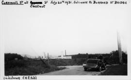
![[View of Cornwall and Cypress Streets near entrance to Burrard Street Bridge]](/uploads/r/null/8/6/d/86dac76ad8cb724cd7224e11a833da97224b6b85e5d0a9820f2a72347779b95d/28b56d29-93a3-4728-8ca0-db35bb4c412d-CVA371-815_142.jpg)
![[View of Cedar Street (Burrard Street), looking north from 1st Avenue]](/uploads/r/null/9/5/1/951361df52bc39caa119f27dbb826caa9f8321d69bffb9d534bf12ba32aa9705/36b8f243-7cb9-4ced-b859-5c83a7f4b85b-CVA371-816_142.jpg)
![[View of Cedar Street (Burrard Street), looking south from 1st Avenue]](/uploads/r/null/5/4/6/546bde6574cf2d5e2d523addd9591e1710627187bd04c3d93cb181a8630c2230/a0010462-bb2d-4682-af2b-e493c71a1bdd-CVA371-817_142.jpg)
![[Cordova Street looking west from Carrall Street]](/uploads/r/null/2/a/3/2a3d21e3af3e2e85d0cf2207073f1924b9cb97f602b6dd55da2a4faee2693230/9b8051d7-2e39-42ec-b77b-929e8483001a-CVA371-1216_142.jpg)

![[View of Granville Street and 37th from the 5200 block, Shaughnessy]](/uploads/r/null/4/7/474b6dcf8ef35087ef9b76000cfbe43c23bd03fbd291f22d3ab8f42be1c46994/34a9c2f5-a821-4376-85e7-c727125ccbbb-A63184_142.jpg)
![[View of] Hastings St. looking east from Hornby](/uploads/r/null/0/4/0470bb9219d126f8bcb407384a6c7238af2d2ff2ec3164ebef90189a224d525d/5d8e50db-7c1a-48a8-9ddf-e12cb8356c36-A09734_142.jpg)

![[C.P.R. right of way between Cordova and Carrall Streets]](/uploads/r/null/c/0/c0eddc6c76c3133f7aa1feaa564938fbeae4de6371f4369968d4436a3da40345/40b2d0ae-d4eb-4b89-835a-a5d5332ce91f-A09979_142.jpg)


![Miscellaneous [38 of 130]](/uploads/r/null/3/7/370c8962c5022681b9caa655aa413f9ae4a96a1b5857d9f9963f661bee67422e/2a98c6b9-de39-4e35-b795-772b5f9b517a-A64364_142.jpg)
![Hastings Street [00 block]](/uploads/r/null/7/8/78eeee5ffd1656608ca5c5d8e0316c16d6729e5071f2cdaae2dd224d9eb34f4c/4b394c4c-143d-48cd-aafc-1bad91736c71-A70084_142.jpg)
![[Inspection of 6th Regiment D.C.O.R. on Cambie Street grounds]](/uploads/r/null/2/e/2ef9009e1370d881168d5b9564a0b91823a5cd05e51b96a18f4d25d756105e43/8584938e-bbc7-4c8e-a54e-d62d04d8f8bc-A26733_142.jpg)

![[Aerial view of Mount Pleasant, South Strathcona and Kensington-Cedar Cottage]](/uploads/r/null/7/5/75ea991fe8319eaffda79b314cbf20e281e35eb2cd8a89eaa898b492242d6282/05f856f3-0a45-41eb-94dc-46cb9d2f7ecf-A63348_142.jpg)

![[Apartment buildings on Granville Street and 16th Avenue]](/uploads/r/null/f/a/fa784ffaa10d1453214e5173ea06e22c00f7a6530a93138d7a34e442453bd490/c98ab7d0-2707-401e-b79e-7ccb519e48d9-A09703_142.jpg)
![Bldgs. [Buildings on the north side of the 600 block of Hastings St.]](/uploads/r/null/6/4/64b973f3b3c9cb2b4aacf7687a576bcdb575fe8a8d0778960483abc44eac347c/96dcae5c-a1ef-4954-9ed8-36549a7fa8f8-A21867_142.jpg)
![[View of the 600 block West Hastings]](/uploads/r/null/9/7/9794e66aa3ed705d8e31ec2ade4b14ca796155c9205fc6a66301c5c6611f8478/15a56ed3-121e-4b13-a226-92b98aa27e1f-A13748_142.jpg)
![Commercial [Drive],18th [Avenue] and Findlay [Streets looking] west](/uploads/r/null/f/f/ff9064f1dffd7a5a8017faaf6ab700e91a15775e8d9375c588f3fc67e9617104/a27b4a41-48b6-46f0-ab9d-962e394b34ce-A43187_142.jpg)
![Streets [89 of 139]](/uploads/r/null/b/b/bb43c82b67a4a7e975d3adb95128b71f6d01bd4575324c28f8395ea9f9fddec9/8897b8b8-c3c0-4a7e-a898-91c092f3a1ab-A64278_142.jpg)


![[One way traffic Seymour St. at Georgia Street, looking south]](/uploads/r/null/6/a/6ab5722dd80ce8659c50534737b97713ef7378106e8777583f6504275d6eb353/28fb7cc1-f428-4efb-9354-3631dfad7020-A43714_142.jpg)
![Naval parade and review [Cambie and West Hastings]](/uploads/r/null/6/e/6eb34cc2d7a336262d8897a793cc11faface3f399fd4d32b966507b117f84be3/6bd11750-ca63-4a9a-8a15-997e4ab35d60-A00552_142.jpg)
![[Pender Street at Cambie Street, looking west]](/uploads/r/null/3/d/3d91c3d4cd2181022a308d60e8fad6da587efcfa17cc0a68527eb95c215bc009/5a8ff240-1741-4881-b137-7b3a66b98a1d-A43705_142.jpg)
![Miscellaneous [66 of 130]](/uploads/r/null/f/3/f3e5c735d932ae4b6cf5264ac1126704a320ba278c9197a1e374be368226338b/a99fc078-5f61-4e29-b051-d858f0963d35-A64400_142.jpg)
![Miscellaneous [41 of 130]](/uploads/r/null/5/e/5e42ab92f4cae68f59e04f28d6c5796d7a4a008adc11be6e92a097993d27c4cf/850f5829-2350-4212-bfdb-20c86d11b5a2-A64367_142.jpg)
![[View of 900 block Seymour Street]](/uploads/r/null/8/a/8a5b02b2c474bf4b469da2d909bb54224b911318574331cce7bc62d4574553c8/7f06889b-efed-40ae-b34c-c6615fa12dd1-CVA810-93_142.jpg)