The Port of Vancouver : Canada's global gateway
- HE 554 .V3 P67 1992
- 1993
462 results with digital objects Show results with digital objects
The Port of Vancouver : Canada's global gateway
C.H. Bailey's Table of distances from port to port.

Part of City of Vancouver fonds
Item is a map prepared as part of the Harbour Headline project of the False Creek Development Study. Map shows existing, interim and ultimate harbour headlines, existing water areas, ownership boundaries, other property lines and lease boundaries in and around False Creek.
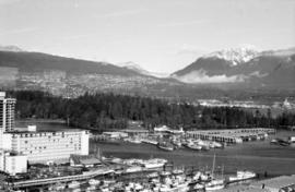
![[North facing cityscape view of the West End showing the] Sheraton-Landmark](/uploads/r/null/7/d/7db38a96995179fe1118994e0c35380cbd8d1bc5909f43a9cb352ba83ea17b88/9e677767-fb6d-4420-91d8-8152f5d4ede1-A59252_142.jpg)
[North facing cityscape view of the West End showing the] Sheraton-Landmark
Part of City of Vancouver fonds
Photograph also shows Coal Harbour and the North Shore
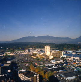
![[Coal Harbour view from Denman Street]](/uploads/r/null/f/4/f4ee6b5b8d147b8a774a97a7b59f6f8c29bb8792a52da1695f47dce307742555/f90773a4-4b21-478d-bd42-505e1d441b47-A16624_142.jpg)
[Coal Harbour view from Denman Street]
Part of City of Vancouver fonds
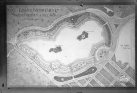
Coal Harbour Improvements Suggested Treatment of Inner Basin
Part of City of Vancouver fonds
Photograph shows map of suggested improvements.
![[Coal Harbour]](/uploads/r/null/e/6/e641a81bbc0d7d8adfb51e6e32ecb57659f5dccdce517fb88dd14160144e3e52/c67b13d2-e877-4fb3-8b2f-0de875c9280a-A16625_142.jpg)
Part of City of Vancouver fonds
![[English Bay after heavy snowfall]](/uploads/r/null/9/8/98d57e6aa43d81b764d660589019a9777086ef8ffa1ac5d9463a527dee1dbf26/46e3a80b-3931-459d-9c09-b1bd42694079-A16571_142.jpg)
[English Bay after heavy snowfall]
Part of City of Vancouver fonds
![[View of Pender Street between Burrard and Thurlow Streets, showing ships in harbour]](/uploads/r/null/7/8/78e5ebf660d4be04085232c4df48a55b2f53fc69b8b24917d11a327c279b273e/238ef5af-164f-4608-b421-7f1ea11419d7-A07605_142.jpg)
[View of Pender Street between Burrard and Thurlow Streets, showing ships in harbour]
Part of Major Matthews collection
J.S. Matthews' notes with print or negative in Archives.
![[View of ship in Coal Harbour and Deadman's Island, from foot of Bute Street]](/uploads/r/null/c/a/ca08065478426138b96322562f2e229721e66f75053f6ef16a6f73c655815bf9/e78cbbbf-fc54-4725-a7a8-7bbee9ee0162-A07648_142.jpg)
[View of ship in Coal Harbour and Deadman's Island, from foot of Bute Street]
Part of Major Matthews collection
J.S. Matthews' notes with print or negative in Archives.

The "First Narrows" Entrance to Vancouver Harbour
Part of Major Matthews collection
Photograph shows the S.S. "Charmer" in Burrard Inlet and a part of the Prospect Point Lighthouse and boathouse
![[Construction of Granville Square]](/uploads/r/null/a/f/a/afa392337c82fdd483821e71e84c783387f62fc34d3e76aa496c753d6b9d3459/7e4197b6-5cc9-41da-bff3-053313fb4718-CVA1385-24_142.jpg)
[Construction of Granville Square]
Part of O.B. Allan Ltd. fonds
Item shows construction at Granville Square (200 Granville St.) as well as harbour with "Hong Kong Mail" and other ship in dock. Caption reads "Project 200 presents: your window on world commerce. Construction now at plaza level and the start of 30 floors. March 1971".

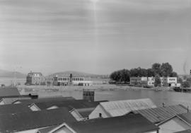
View of Fisherman's Cove taken from highway to Horseshoe Bay
Part of Vancouver Express fonds
![Vancouver Harbour from the Stadacona [Apartment Building]](/uploads/r/null/a/d/a/adad648f7aa2e6b96320fda8037a95ccb21b883a2daafadc021660a228ca983f/ab1ae707-0322-41fe-8c37-3456ba2ca84d-CVA289-038_142.jpg)
Vancouver Harbour from the Stadacona [Apartment Building]
Part of William Orson Banfield fonds

Part of William Orson Banfield fonds

Part of William Orson Banfield fonds
![West Coast trip [with Sherwood Lett, Arthur Lord, W.O. Banfield] : Victoria Harbor](/uploads/r/null/1/a/e/1aeb4a3bc33b7d8193df08812fdb554308428cb72e2c2037cb92b54e2c4ab46b/4e8dd226-9d82-4de4-9fe8-fabe4622f1f9-CVA289-003_142.jpg)
West Coast trip [with Sherwood Lett, Arthur Lord, W.O. Banfield] : Victoria Harbor
Part of William Orson Banfield fonds
![Anchorage [4 large ships anchored in harbour]](/uploads/r/null/7/2/1/72172dde853b999550f9706c094e552f217cbfb2dfee81def2e803b58e216eb5/5e45b343-7a82-4860-b0fe-8c2e79f96eec-CVA293-102_142.jpg)
Anchorage [4 large ships anchored in harbour]
![Anchorage [4 large ships anchored in harbour]](/uploads/r/null/b/1/7/b17afd6d1a0943c297e40d302881bdf64981911420bd54c8a8c8d5f2e9cf5143/ae1459eb-8f9a-4300-b7c0-693ace510103-CVA293-102_142.jpg)
Anchorage [4 large ships anchored in harbour]
![Evening anchorage [3 large ships and small sailboat in harbour at sunset]](/uploads/r/null/8/7/2/8727d40fe77cecc8f1a9421b38a760afe0c9aa58d7af058a56e90ce73a12fdaf/9df717c8-8214-4ae5-a04e-784752c2a4ba-CVA293-103_142.jpg)
Evening anchorage [3 large ships and small sailboat in harbour at sunset]
![Outward bound [Ferncliff leaving the harbour]](/uploads/r/null/0/d/4/0d48abd626ba40c2b0d1fe79807eaa4cf505575e2ddce6ff434ab2a594cfffa7/e4e279ea-7b71-4405-a67c-ed0859a6a8b8-CVA293-128_142.jpg)
Outward bound [Ferncliff leaving the harbour]
![[Four] idle tankers near Portovenere](/uploads/r/null/9/1/e/91e7c32c1eea8c6d3b2a4dbf33f51e96258a34618bdd8720bfd4d6974f0537d5/babfaa6a-6c0e-4bde-b7e4-66feee47dfb6-CVA293-130_142.jpg)
[Four] idle tankers near Portovenere


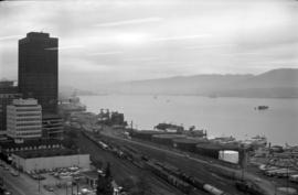
Vancouver from top of old Hotel Vancouver
Photograph shows a view looking north showing Pier B-C, the Main Post Office, the Royal Bank Building and ferries

Vancouver Harbour from Rowing Club, Stanley Park
Howe Sound : H.M.S.S. Discovery

Scenes : Vancouver Harbour and skyline etc.

British Columbia - Vancouver skyline
Item is photograph showing Coal Harbour and Stanley Park.

British Columbia - Vancouver skyline
Item is photograph showing Stanley Park and Coal Harbour.

British Columbia - Vancouver skyline
Item is photograph showing Coal Harbour and Stanley Park.
British Columbia - Vancouver skyline
Item is photograph showing view of Coal Harbour and Stanley Park taken from Westcoast building.
British Columbia - Vancouver skyline : view from north side of Westcoast bldg
Item is photograph showing view of Coal Harbour and Stanley Park from Westcoast Energy building.

British Columbia - Vancouver skyline : view from north side of Westcoast bldg
Item is photograph showing view of Coal Harbour and Stanley Park from Westcoast Energy building.

British Columbia - Vancouver skyline : view from north side of Westcoast bldg
Item is photograph showing view of Coal Harbour and Stanley Park from Westcoast Energy building.

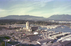
British Columbia - Vancouver skyline : Westcoast bldg. and scenery from inside
Item is photograph showing Coal Harbour and Stanley Park from Westcoast Energy office building in downtown Vancouver.

Item is photograph showing an aerial view downtown Vancouver looking northwest towards Coal Harbour and Stanley Park.

British Columbia - Vancouver skyline
Item is photograph showing Coal Harbour and Stanley Park.
British Columbia - Vancouver skyline
Item is aerial photograph showing Coal Harbour and Stanley Park.

British Columbia - Vancouver skyline
Item is photograph showing an aerial view of Burrard Inlet showing the southern shoreline and parts of Stanley Park.

British Columbia - Vancouver skyline
Item is aerial photograph showing part of downtown Vancouver, Stanley Park and Coal Harbour.
British Columbia - Vancouver skyline
Item is aerial photograph showing part of downtown Vancouver looking north towards Stanley Park and Coal Harbour.

British Columbia - Vancouver skyline
Item is aerial photograph showing downtown Vancouver and Burrard Inlet.

British Columbia - Vancouver skyline
Item is aerial photograph showing Coal Harbour and Burrard Inlet

British Columbia - Vancouver skyline
Item is aerial photograph of Coal Harbour and Burrard Inlet.

View shows Lions Gate Bridge and Stanley Park.
![Georgia Day [on the deck of a] Vancouver-Victoria boat in First Narrows](/uploads/r/null/6/6/668581126068bef64727574d042412d1492c0510d297779d4bfda0ebf271604a/5b6dd093-9969-4960-850f-995e137a5ca3-A03305_142.jpg)
Georgia Day [on the deck of a] Vancouver-Victoria boat in First Narrows
![[View of] Victoria Harbour](/uploads/r/null/0/7/074ebb16365cb625f74f47be3cfe3f0ae2a9a727d6c149abfcbba485f959f53b/b1a27d9b-dbad-4511-be41-95bf15ef2fc1-A06937_142.jpg)
![[View of] Ocean Falls [harbour and buildings]](/uploads/r/null/3/3/33daeb90796231f592329cba7a2cbd32a2d2e5ec9d397a7151a925a416d514b8/860dc270-0c78-4f59-9c8e-a01712ccce45-A07221_142.jpg)
[View of] Ocean Falls [harbour and buildings]
![[View of] Parliament Building , illuminated [at night, Victoria, B.C.]](/uploads/r/null/d/c/dc81d0d58c91faf1768ff62befeceee86d29ea5df52f6d2f0480ecd47adac3ec/efed1773-3d50-494b-8786-acab1c88657f-A06943_142.jpg)
[View of] Parliament Building , illuminated [at night, Victoria, B.C.]