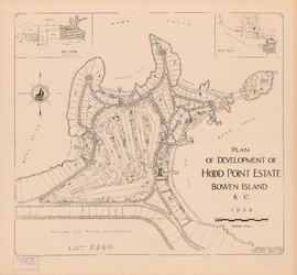
Plan of development of Hood Point Estate, Bowen Island, B.C., 1928
Perspective of Greater Vancouver from Grouse Mountain (elevation 4000 ft.)
Municipality of South Vancouver
University Endowment Lands : plan of units no. 1 and 2
Lot numbers, boundaries, railway lines and street names in the municipality of Point Grey
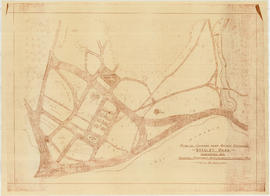
Plan of grounds near bridge entrance, Stanley Park, Vancouver, B.C. : showing proposed improvements coloured red
Map showing route Vancouver to Mission
North America - West Coast. British Columbia. Burrard Inlet
Plan of town of Lonsdale : situate [sic] on harbour opposite City of Vancouver
Vancouver South, British Columbia
Plan to accompany by-law no. [Blank] being a by-law to amend by-law no. 4054 being the street naming by-law
Selected park programs for additional park sites 1959-1976
Plan of Cambie St. grounds
Official highway map of British Columbia, northern Washington, Idaho and Montana
Metropolitan Vancouver
British Columbia : Port Moody sheet : west of seventh, east and west of coast meridians
Powell Lake
Municipality of South Vancouver
Freight lines : British Columbia Electric Railway Company Limited, Vancouver and Lulu Island Railway Company (Canadian Pacific Railway Company, Lessee)
Plan showing bus routes and stops in the downtown area, Vancouver, B.C., October 1961
Plan of Point Grey Municipality
New Westminster and Yale [districts]
Plan no. 2 : showing city distribution system, pressure districts, fire stations and water flow test locations : City of Vancouver, British Columbia
Map showing the line of boundary between the United States and British possessions
[Cross sections of ocean floor between Vancouver Island and mainland of British Columbia]
Vancouver sheet, British Columbia
Pictorial map of Greater Vancouver showing dates of settlement in specific areas and opening dates of regional landmarks
Plan of the municipality of South Vancouver
Plan of provincial government property being a portion of townsite of Vancouver and sub-division of lot 540, group 1, New Westminster District, B.C., to be sold by public auction at Vancouver, B.C.
Plan of part of sub-division of district lot 540, South Vancouver, provincial government property
Plan of provincial government property being a sub-division of a portion of expired timber lease situated in North Vancouver, New Westminster district, B.C., to be sold by public auction
Plan of sub-division of lot 2027, group 1, New Westminster District, B.C., to be sold by public auction at Vancouver, B.C.
Plan of part of West Vancouver District
False Creek Basin
North-east False Creek Map
Vancouver
Sheet S.V. 10 : Dumfries Street to Fairmont Street and Twenty-seventh Avenue to Thirty-seventh Avenue
Sheet S.V. 11 : Fleming Street to Killarney Street and Thirty-seventh Avenue to Forty-eighth Avenue
Sheet S.V. 12 : Fleming Street to Raleigh Street and Forty-eighth Avenue to Newport Avenue
Sheet S.V. 13 : Borden Street to Jellicoe Street and Sixtieth Avenue to Fraser River
Sheet S.V. 14 : Duchess Street to Boundary Road and Twenty-ninth Avenue to Fortieth Avenue
Sheet S.V. 16 : Dawson Street to Boundary Road and Fiftieth Avenue to Sixty-third Avenue
Sheet S.V. 17 : Jellicoe Street to Boundary Road and Sixty-third Avenue to Fraser River
Key plan
Map of City of Vancouver, British Columbia [index map]
Plan of district lot boundaries, City of Vancouver, B.C. [index map]
Sheet 1: Slocan Street to Boundary Road and Triumph Street to Burrard Inlet
Sheet 2: Slocan Street to Boundary Road and Charles Street to Triumph Street


![Plan of town of Lonsdale : situate [sic] on harbour opposite City of Vancouver](/uploads/r/null/c/5/d/c5d4b56db1d7f9e1cf57dd5a974f6fcb23507e64543bad1bdd8f62139042389f/1cc57eaf-6c92-438e-a65d-335940738df7-MAP686_142.jpg)

![Plan to accompany by-law no. [Blank] being a by-law to amend by-law no. 4054 being the street nam...](/uploads/r/null/3/a/d/3ad2e1a740be487ac9cdd1a7e10ac6cbe15cda433b0937bde9a0837696e4148a/802101ef-808b-4353-a5fe-3100da56eeb7-MAP71c_142.jpg)


![New Westminster and Yale [districts]](/uploads/r/null/6/a/f/6af222cb96f4a11f05414783d2a53fe8b7ae9bc99fe2919b35111fb34ec8ef04/8a474785-2c59-42e3-9626-48d0f6f45c3a-MAP82_142.jpg)

![[Cross sections of ocean floor between Vancouver Island and mainland of British Columbia]](/uploads/r/null/c/a/6/ca687b43e46696a0c1d9223ef1e80ebe50bba0ea48092c458b525fc90f7b517c/7d458083-64ae-4682-be03-8fd1211e38c9-MAP8b_142.jpg)


![Map of City of Vancouver, British Columbia [index map]](/uploads/r/null/b/4/b4070d13913e90841a24384f7c94ab9f22595ff9bde62429edb46fd5ed60a75a/f4bb676f-1639-4811-82bf-2a0d4defd87e-MAP779_142.jpg)
![Plan of district lot boundaries, City of Vancouver, B.C. [index map]](/uploads/r/null/9/4/9469805f0ad98fa8c476e2fa1bd641a165448bbfe6840da2ca337894637001a4/9199ff56-1884-4c1f-8d1c-1a513de71a3d-MAP779_142.jpg)

