
Vancouver Harbour : Sheet 2 (Point Grey to Second Narrows)
- AM1594-: MAP 40b
- Item
- 1942
Part of City of Vancouver Archives technical and cartographic drawing collection
item is a nautical chart of Burrard Inlet and Vancouver Harbour from Point Grey in the west to Second Narrows in the east, showing soundings in fathoms, tidal information, anchorages, beacons, and waterfront businesses. Street names are shown on land areas. A Royal Canadian Air Force bombing range at Jericho Beach is identified as a danger area.


![Granville [Townsite], B.C. Aug., 1885](/uploads/r/null/1/a/4/1a45ddd637fe3f3726748d5096017a8461446b9a013c408ed2b1666c8433e1f9/405fdc0d-6d88-41b7-937f-36cc7f51518a-MAP553_142.jpg)


![Dock strike [15 ships in harbour at night]](/uploads/r/null/3/a/0/3a0ed8ecf3d09c2acdb65f33e72b44178809cc61a17d7444695cab3cdf738b7f/238f53a5-2b24-40a1-9624-c91f008def5d-CVA293-101_142.jpg)
![Dock strike [15 ships in harbour at night]](/uploads/r/null/d/c/f/dcf8da918f5b0e16726d8549fd94e80132801b020505f943fcacc06f9b671fe7/af80dc90-8e78-48d4-a344-5eb254c164a3-CVA293-101_142.jpg)
![Anchorage [4 large ships anchored in harbour]](/uploads/r/null/7/2/1/72172dde853b999550f9706c094e552f217cbfb2dfee81def2e803b58e216eb5/5e45b343-7a82-4860-b0fe-8c2e79f96eec-CVA293-102_142.jpg)
![Anchorage [4 large ships anchored in harbour]](/uploads/r/null/b/1/7/b17afd6d1a0943c297e40d302881bdf64981911420bd54c8a8c8d5f2e9cf5143/ae1459eb-8f9a-4300-b7c0-693ace510103-CVA293-102_142.jpg)
![Evening anchorage [3 large ships and small sailboat in harbour at sunset]](/uploads/r/null/6/0/d/60d16998ae9bc1a2653fe1625d8dabcb4e58d9fb8720a1470541fd00dd6f360d/fb01b38d-d3f5-474d-95f0-9c270036e78a-CVA293-103_142.jpg)
![Evening anchorage [3 large ships and small sailboat in harbour at sunset]](/uploads/r/null/8/7/2/8727d40fe77cecc8f1a9421b38a760afe0c9aa58d7af058a56e90ce73a12fdaf/9df717c8-8214-4ae5-a04e-784752c2a4ba-CVA293-103_142.jpg)
![Twilight anchorage [ship in harbour]](/uploads/r/null/4/9/2/4923632d88dba51cffecddb31cbfd4980f43232a820db1e148f7cd30c20a8970/510e5af0-3f17-4494-8174-f501decfbc32-CVA293-104_142.jpg)
![Twilight anchorage [ship in harbour]](/uploads/r/null/0/7/0/070fcdba14a97229fe34dfd252185ba764db3a4c1c508cc33ded4cf07a8e200e/6db0a17a-a8a8-4177-8bd6-c2233df68cf4-CVA293-104_142.jpg)
![Night anchorage [ship in harbour at night]](/uploads/r/null/a/c/7/ac7becd2001978d369e1369a06041cedb04449b387fc7615e117d5f85b1ad96f/aaf4055b-b828-47aa-8665-042681035b65-CVA293-105_142.jpg)
![Night anchorage [ship in harbour at night]](/uploads/r/null/0/6/6/06647be38f6807165c759737e53d28f14dd6191776eeab4143c2539975e9a5fd/06d22039-ab94-425f-9b91-95dc179236d1-CVA293-105_142.jpg)
![Outward bound [Ferncliff leaving the harbour]](/uploads/r/null/9/4/1/941ada3c187bf82c8b708a7f34b8b35801419807e0815d2ad523a12b9e6570be/b8290159-6586-40fc-a089-d7bdd4808d85-CVA293-128_142.jpg)
![Outward bound [Ferncliff leaving the harbour]](/uploads/r/null/0/d/4/0d48abd626ba40c2b0d1fe79807eaa4cf505575e2ddce6ff434ab2a594cfffa7/e4e279ea-7b71-4405-a67c-ed0859a6a8b8-CVA293-128_142.jpg)

![[Four] idle tankers near Portovenere](/uploads/r/null/4/9/a/49a160c0e115c2c10cd349b5b8d207af7a66d75ebc0e3ca4c50a7edbca20ce86/08ab1ef1-ff92-4cbf-9bc9-4323addf96c4-CVA293-130_142.jpg)
![[Four] idle tankers near Portovenere](/uploads/r/null/9/1/e/91e7c32c1eea8c6d3b2a4dbf33f51e96258a34618bdd8720bfd4d6974f0537d5/babfaa6a-6c0e-4bde-b7e4-66feee47dfb6-CVA293-130_142.jpg)
![Solar Spotlight (Fesco Lines in harbour]](/uploads/r/null/0/e/4/0e478f009e0b187c741229295a86f23b91a00adf0cca86689859318176660c7d/b97d83b4-19b9-4fe7-b073-07340f13b1a6-CVA293-131_142.jpg)
![Solar Spotlight (Fesco Lines in harbour]](/uploads/r/null/f/3/7/f3731082e79e6a0a8ae32795ea38092a18d40429154bc37d8b51ed099dfa471a/43e700f4-a1d0-4a88-adac-c18d46d983e0-CVA293-131_142.jpg)
![No wheat [view from Kitsilano Beach of freighter anchored in the harbour]](/uploads/r/null/a/f/7/af7f69cd835c3dcc952e2f300902fff6acddff87492c075566311f576b51c92b/8c5a57f2-5cdd-45ed-afd7-78b655941080-CVA293-135_142.jpg)
![No wheat [view from Kitsilano Beach of freighter anchored in the harbour]](/uploads/r/null/2/3/6/23667b976ce7a35f7a67eb8c0fbe7bf5f94840e88af4840d63ba4336aedc66f9/40c88020-4643-490e-afbc-b432b9612f3b-CVA293-135_142.jpg)


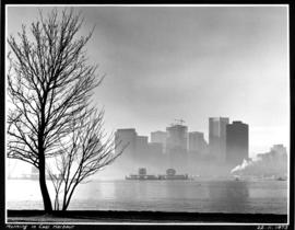
![[View of Vancouver harbour]](/uploads/r/null/d/3/9/d39622303c8efca71d11bdf6c2d80bac5f657ee961622b9b0c742c47d5652adf/6c56b366-414d-4805-bc1a-6edbc4231fcf-2018-020_142.jpg)
![Plan showing suggested development fronting D.L. [District Lot] 274, North Vancouver](/uploads/r/null/1/e/4/1e43e8f9bca67073ae3aeaf7041d567d42e6a95a29358355f1cd94909f486f68/d9652aca-fa6d-42c1-880a-e230a325dda4-MAP589_142.jpg)
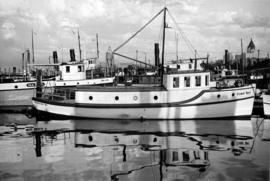
![[Boats in] Coal Harbour](/uploads/r/null/4/e/4e0ce74158796911dcd444ae208a0139e91a4251c536cf44042cbf4336ab4be4/9190958d-05ac-45a7-ae92-6df410a7bab9-A01926_142.jpg)
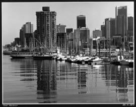
![[View of Coal Harbour from Vancouver]](/uploads/r/null/a/d/ad3804d91a35387f53f4c5858b7f68b9c622339a85523df7f8917001ab7d3c74/187cecca-d78f-4911-826f-3d952d4df917-A01985_142.jpg)
![[Coal Harbour, showing part of Stanley Park, Deadman's Island, and houseboats]](/uploads/r/null/1/2/12067ca2ea5ea0ff39ee45868194a05deff43c7c02b79dc9558e8710362bcd57/cc755324-9751-4940-ac1f-281c8e8867e0-A02323_142.jpg)