
British Columbia - Vancouver skyline
- AM1435-: CVA 1435-1
- Item
- [197-?]
Item is photograph showing an aerial view of Burrard Inlet showing the southern shoreline and parts of Stanley Park.
462 results with digital objects Show results with digital objects
British Columbia - Vancouver skyline
Item is photograph showing an aerial view of Burrard Inlet showing the southern shoreline and parts of Stanley Park.

British Columbia - Vancouver skyline
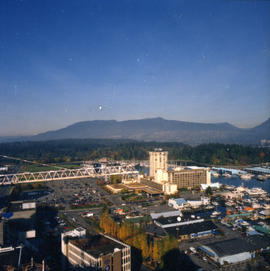
Item is aerial photograph showing part of downtown Vancouver, Stanley Park and Coal Harbour.
British Columbia - Vancouver skyline
Item is aerial photograph showing part of downtown Vancouver looking north towards Stanley Park and Coal Harbour.

British Columbia - Vancouver skyline
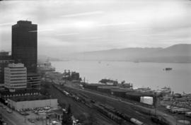
Item is aerial photograph showing downtown Vancouver and Burrard Inlet.

British Columbia - Vancouver skyline
Item is aerial photograph showing Coal Harbour and Burrard Inlet

British Columbia - Vancouver skyline
Item is aerial photograph of Coal Harbour and Burrard Inlet.

British Columbia - Vancouver skyline
Item is photograph showing Coal Harbour and Stanley Park.

British Columbia - Vancouver skyline
Item is photograph showing Stanley Park and Coal Harbour.

British Columbia - Vancouver skyline
Item is photograph showing Coal Harbour and Stanley Park.
British Columbia - Vancouver skyline
Item is photograph showing view of Coal Harbour and Stanley Park taken from Westcoast building.
British Columbia - Vancouver skyline : view from north side of Westcoast bldg
Item is photograph showing view of Coal Harbour and Stanley Park from Westcoast Energy building.

British Columbia - Vancouver skyline : view from north side of Westcoast bldg
Item is photograph showing view of Coal Harbour and Stanley Park from Westcoast Energy building.

British Columbia - Vancouver skyline : view from north side of Westcoast bldg
Item is photograph showing view of Coal Harbour and Stanley Park from Westcoast Energy building.

British Columbia - Vancouver skyline : Westcoast bldg. and scenery from inside
Item is photograph showing Coal Harbour and Stanley Park from Westcoast Energy office building in downtown Vancouver.

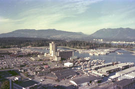
Item is photograph showing an aerial view downtown Vancouver looking northwest towards Coal Harbour and Stanley Park.

Vancouver from top of old Hotel Vancouver
Photograph shows a view looking north showing Pier B-C, the Main Post Office, the Royal Bank Building and ferries
![[View of] Ocean Falls [harbour and buildings]](/uploads/r/null/3/3/33daeb90796231f592329cba7a2cbd32a2d2e5ec9d397a7151a925a416d514b8/860dc270-0c78-4f59-9c8e-a01712ccce45-A07221_142.jpg)
[View of] Ocean Falls [harbour and buildings]
![[View of] Parliament Building , illuminated [at night, Victoria, B.C.]](/uploads/r/null/d/c/dc81d0d58c91faf1768ff62befeceee86d29ea5df52f6d2f0480ecd47adac3ec/efed1773-3d50-494b-8786-acab1c88657f-A06943_142.jpg)
[View of] Parliament Building , illuminated [at night, Victoria, B.C.]
![[View of] Victoria Harbour](/uploads/r/null/0/7/074ebb16365cb625f74f47be3cfe3f0ae2a9a727d6c149abfcbba485f959f53b/b1a27d9b-dbad-4511-be41-95bf15ef2fc1-A06937_142.jpg)

Vancouver Harbour from Rowing Club, Stanley Park
Howe Sound : H.M.S.S. Discovery

Scenes : Vancouver Harbour and skyline etc.

View shows Lions Gate Bridge and Stanley Park.
![Georgia Day [on the deck of a] Vancouver-Victoria boat in First Narrows](/uploads/r/null/6/6/668581126068bef64727574d042412d1492c0510d297779d4bfda0ebf271604a/5b6dd093-9969-4960-850f-995e137a5ca3-A03305_142.jpg)
Georgia Day [on the deck of a] Vancouver-Victoria boat in First Narrows


View of Fisherman's Cove taken from highway to Horseshoe Bay
Part of Vancouver Express fonds
![Anchorage [4 large ships anchored in harbour]](/uploads/r/null/7/2/1/72172dde853b999550f9706c094e552f217cbfb2dfee81def2e803b58e216eb5/5e45b343-7a82-4860-b0fe-8c2e79f96eec-CVA293-102_142.jpg)
Anchorage [4 large ships anchored in harbour]
![Anchorage [4 large ships anchored in harbour]](/uploads/r/null/b/1/7/b17afd6d1a0943c297e40d302881bdf64981911420bd54c8a8c8d5f2e9cf5143/ae1459eb-8f9a-4300-b7c0-693ace510103-CVA293-102_142.jpg)
Anchorage [4 large ships anchored in harbour]
![Evening anchorage [3 large ships and small sailboat in harbour at sunset]](/uploads/r/null/8/7/2/8727d40fe77cecc8f1a9421b38a760afe0c9aa58d7af058a56e90ce73a12fdaf/9df717c8-8214-4ae5-a04e-784752c2a4ba-CVA293-103_142.jpg)
Evening anchorage [3 large ships and small sailboat in harbour at sunset]
![Outward bound [Ferncliff leaving the harbour]](/uploads/r/null/0/d/4/0d48abd626ba40c2b0d1fe79807eaa4cf505575e2ddce6ff434ab2a594cfffa7/e4e279ea-7b71-4405-a67c-ed0859a6a8b8-CVA293-128_142.jpg)
Outward bound [Ferncliff leaving the harbour]
![[Four] idle tankers near Portovenere](/uploads/r/null/9/1/e/91e7c32c1eea8c6d3b2a4dbf33f51e96258a34618bdd8720bfd4d6974f0537d5/babfaa6a-6c0e-4bde-b7e4-66feee47dfb6-CVA293-130_142.jpg)
[Four] idle tankers near Portovenere

C.H. Bailey's Table of distances from port to port.
North Vancouver-Vancouver ferry schedule : January 13, April 28, April 29, 1969
The Vancouver Harbour : a preliminary position paper
What is the National Harbours Board?
Part of Harold D. Kalman fonds
![[View of Burrard Inlet from Point Grey]](/uploads/r/null/e/3/e320d8072b352225b343a6bf036a24dfbe3d1f2d722001dd0b12d0aa899d36bb/bb12fe87-3475-4839-9e59-891393008d05-A64782_142.jpg)
[View of Burrard Inlet from Point Grey]
Part of Major Matthews collection
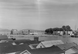
Panoramic view showing a pier and Stanley Park in background.
![[View of Coal Harbour and the rear of Queen Victoria's Memorial from Stanley Park]](/uploads/r/null/4/3/43de497a997e0f724c44d286a5777cf01177bc80cf064bb190ff8d322f1a3431/ab850521-fb13-4aa6-8b76-7ae76dab47a7-A64524_142.jpg)
[View of Coal Harbour and the rear of Queen Victoria's Memorial from Stanley Park]
Part of Major Matthews collection
Photograph also shows two boys and boats anchored in the harbour.

Part of Major Matthews collection
Panoramic view showing Burrard Inlet including 42 ocean steamers in port of which 25 were for grain cargoes, 17 vessels at berth (not shown in photograph) and the Harbour Commissioners wharf and Grain Elevator No. 1 and log booms

Part of Major Matthews collection
Panoramic view
![[Construction of Granville Square]](/uploads/r/null/a/f/a/afa392337c82fdd483821e71e84c783387f62fc34d3e76aa496c753d6b9d3459/7e4197b6-5cc9-41da-bff3-053313fb4718-CVA1385-24_142.jpg)
[Construction of Granville Square]
Part of O.B. Allan Ltd. fonds
Item shows construction at Granville Square (200 Granville St.) as well as harbour with "Hong Kong Mail" and other ship in dock. Caption reads "Project 200 presents: your window on world commerce. Construction now at plaza level and the start of 30 floors. March 1971".
![Plan showing suggested development fronting D.L. [District Lot] 274, North Vancouver](/uploads/r/null/1/e/4/1e43e8f9bca67073ae3aeaf7041d567d42e6a95a29358355f1cd94909f486f68/d9652aca-fa6d-42c1-880a-e230a325dda4-MAP589_142.jpg)
Plan showing suggested development fronting D.L. [District Lot] 274, North Vancouver
Item is a map showing contours above and soundings below the low water mark along a portion of the North Vancouver shoreline. Map has been annotated with what appears to be the outline of a possible development on the waterfront.
![[Queen Victoria Memorial Fountain]](/uploads/r/null/f/b/c/fbc8607cfbb0c77b361e1848d986e2ef78b715bb554ba8a0769d86d3e082ed38/bebd2627-01c5-42b2-9d75-24f222aaf42d-MonP32_142.jpg)
[Queen Victoria Memorial Fountain]
Part of Major Matthews collection
Panoramic view shows Coal Harbour, Deadman's Island
![[Replica Boeing B&W-1 float plane on Coal Harbour]](/uploads/r/null/3/2/32025b8403038a739a5d027251034c50ae7df3bb3146e0ffddd172cfea4af1b9/cb8061f3-67db-4d22-8d79-2d54221ef558-A23525_142.jpg)
[Replica Boeing B&W-1 float plane on Coal Harbour]
Part of Major Matthews collection
Photograph shows the Royal Vancouver Yacht Club. The event commemorates the 50th anniversary of the first mail flight from Canada to the United States.
![[Parliament Buildings, Victoria, B.C.]](/uploads/r/null/d/0/d0f3827fcba74f71918e13419e6a10f2abbb53aad9ccd3b6e764a59a8e42e0d6/58091dda-eca1-43d9-83d4-2ad2d2a77bb5-A04350_142.jpg)
[Parliament Buildings, Victoria, B.C.]
Part of Major Matthews collection
J.S. Matthews' notes with print or negative in Archives.

The "First Narrows" Entrance to Vancouver Harbour
Part of Major Matthews collection
Photograph shows the S.S. "Charmer" in Burrard Inlet and a part of the Prospect Point Lighthouse and boathouse

City and Deadman's Island near Nine 0'Clock Gun
Part of Major Matthews collection

Part of Major Matthews collection
J.S. Matthews' notes with print or negative in Archives.